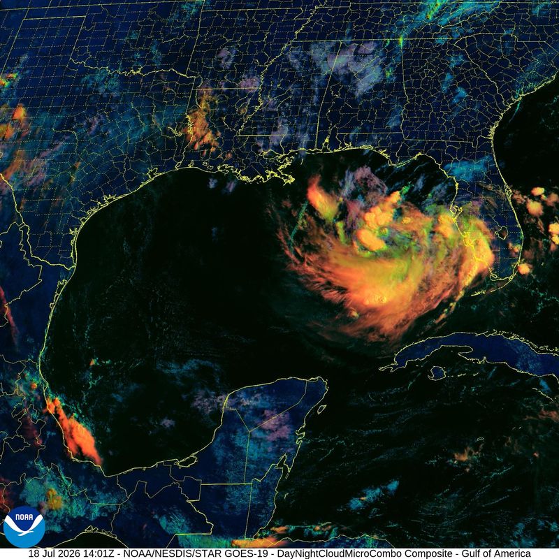
A disorganized but formidable-looking mass of thunderstorm activity has developed just west of Florida over the eastern Gulf, and is in no hurry to clear the area.
A development of storms just west of Florida has been named by the National Hurricane Center as Invest 91L as of Saturday morning. Just before 1 p.m., the National Hurricane Center said the disturbance has a 40% chance of developing over the next seven days over the warm Gulf waters.

The National Hurricane Center on its tropical outlook map as of 2 p.m. July 18, was watching the Gulf system and two tropical waves. Invest 91L which will activate regular model runs and more satellite coverage.
Here’s a look at the developing system.
What is an invest? Is Invest 91L a tropical storm?
The invest has a low chance of development over the next two days, as it moves slowly to the north and northwest.
The term “invest” is used every hurricane season and is short for investigation. It is accompanied by a number from 90 to 99, accompanied by “L,” “E” or “C,” respectively. It is used to identify areas that may possibly develop into a tropical depression or tropical storm within the next seven days.
Spaghetti models, satellite views of system Invest 91L, west of Florida
National Hurricane Center watching Gulf disturbance,
The National Hurricane Center on its tropical outlook map as of 2 p.m. July 18, was watching the Gulf system and two tropical waves.
Northeastern Gulf of America: Low pressure across the eastern Gulf will remain nearly stationary through the weekend, forecasters said. The system will begin to drift northward through early next week, supporting periods of thunderstorms.
Some gradual development of this system is possible, the weather outlook said. Interests along the Florida west coast and Florida Panhandle should monitor the progress of this system as it is expected to bring heavy rain to portions of that region during the next several days.
What’s next?
We will continue to update our tropical weather coverage to bring you the most current information you need to protect your home and family.
Stay informed. Get weather alerts via text
You can get all of Florida’s best content directly in your inbox each weekday day by signing up for the free newsletter, Florida TODAY, at https://naplesnews.com/newsletters.
This article originally appeared on Naples Daily News: Invest 91L near Florida may become a tropical storm: Spaghetti models
Reporting by C. A. Bridges, Cheryl McCloud and Hana Khalyleh, USA TODAY NETWORK – Florida / Naples Daily News
USA TODAY Network via Reuters Connect
By C. A. Bridges, Cheryl McCloud and Hana Khalyleh, USA TODAY NETWORK – Florida | USA TODAY Network