(This story has been updated to add more information.)
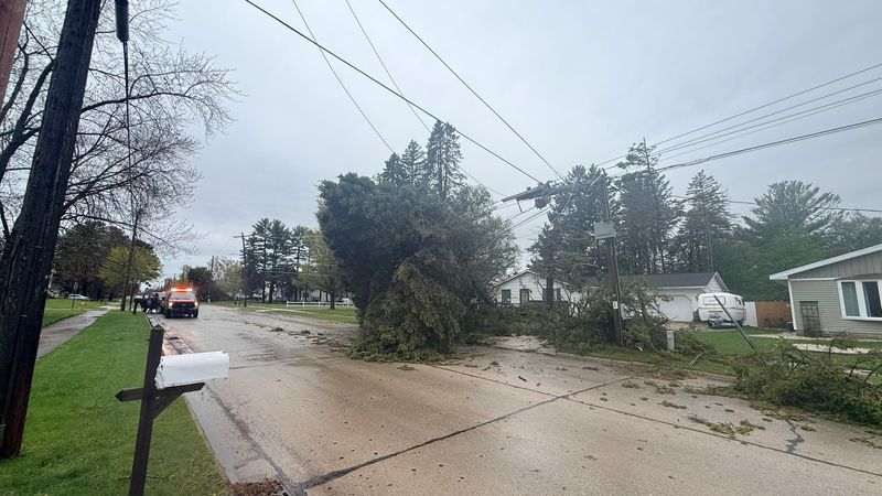
MANITOWOC COUNTY – Severe thunderstorms slammed Manitowoc County on Sunday, May 17, knocking out power, downing trees and power lines, and prompting officials to urge residents to stay off the roads unless travel is necessary.

Manitowoc County storm knocks out power and blocks roads
In Two Rivers, city officials said utility, public safety, public works and parks crews were responding Sunday evening to multiple reports of downed trees and power lines. Officials asked residents to stay home unless they had an immediate need to be on the road. Memorial Drive was among the areas affected by downed power lines.
According to a 7:26 p.m. update from Two Rivers Utilities, crews did not yet have an estimated time for restoring power after storm damage caused widespread outages across the city. Utility officials said the damage was extensive, and mutual aid crews had been called in to assist with restoration efforts.
The outages were affecting the south, east and north sides of Two Rivers, as well as areas near Sandy Bay Road. Electric and Public Works crews were working Sunday to restore power and clear fallen trees.
Two Rivers Utilities urged residents to stay away from downed utility lines and to assume any line is live and dangerous. Customers without power were asked to call 920-793-5555. Officials thanked residents for their patience as crews respond to damage reported across the city.
In Manitowoc, Manitowoc Public Utilities said at 5:35 p.m. that about 90% of affected customers should have power restored. Crews were still working on broken poles, downed lines and smaller outages. The utility warned residents to stay away from downed lines, which could still be energized. More outage information is available at https://www.mpu.org/current-outages/.
National Weather Service warns more severe weather could hit northeast Wisconsin
The National Weather Service said Manitowoc County remained under a hazardous weather outlook Sunday night. Forecasters warned that isolated severe storms could continue into the evening, with threats including large hail, gusty to damaging winds and heavy rain.
Additional thunderstorms and locally heavy rainfall were also possible Monday into Tuesday, though timing remained uncertain.
Manitowoc County weather forecast after Sunday storm
Sunday night brings another chance of showers and thunderstorms before 10 p.m., with a slight chance of storms returning after 2 a.m. Patchy fog is possible late, and winds could gust as high as 22 mph.
Monday: More showers and thunderstorms are possible, with a high near 76 and south winds gusting up to 24 mph.
Monday night: Showers and thunderstorms become more likely after 1 a.m. The low will be around 54, and rainfall could be heavier in thunderstorms.
Tuesday: Rain chances continue early before skies gradually clear. The high will be near 75, with gusts up to 26 mph.
By midweek, conditions are expected to turn cooler and drier, with highs mostly in the 50s before a slight chance of showers returns late in the week.
Contact Brandon Reid at breid@usatodayco.com.
This article originally appeared on Manitowoc Herald Times Reporter: Severe weather pounds Manitowoc County with outages and damage
Reporting by Brandon Reid, Manitowoc Herald Times Reporter / Manitowoc Herald Times Reporter
USA TODAY Network via Reuters Connect