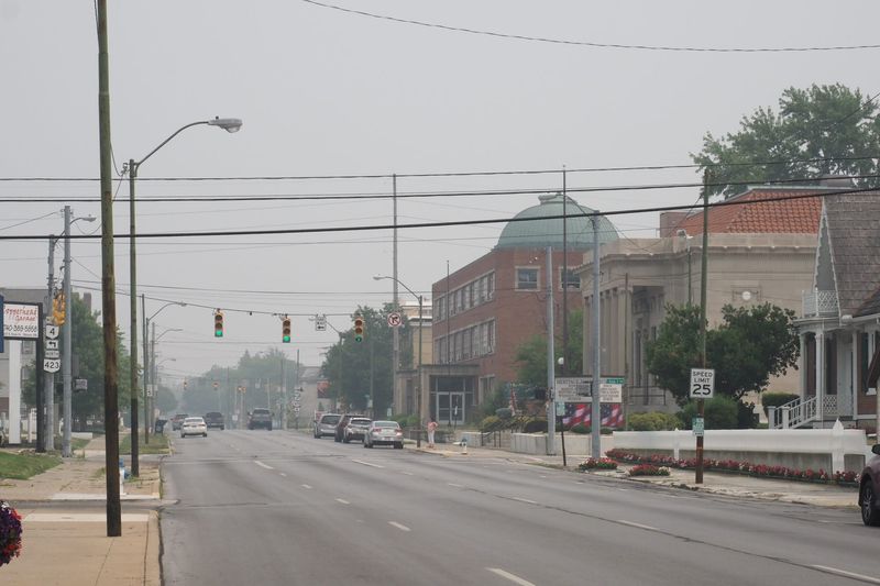
Officials recommend that Marion residents stay inside while wildfire smoke blows into the area.
The Ohio EPA has issued an Air Quality Advisory for the all of Ohio until midnight July 17. Marion’s air quality falls into “very unhealthy,” according to AccuWeather.

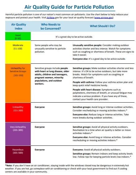
Air quality is measured on a scale of 0-250+, with zero being excellent and 250+ measuring dangerous. Marion’s air quality as of 9:30 a.m. on July 17 hit 222, making it “very unhealthy.”
Columbus is currently labeled as “dangerous.”
According to AccuWeather, sensitive groups might feel health effects immediately, whereas healthy individuals are likely to experience difficulty breathing and throat irritation. Everyone should avoid outdoor activity if possible.
The Ohio EPA issued a statement telling Ohioans to look out for symptoms like wheezing, coughing, chest tightness, dizziness or irritation in the nose, throat or eyes.
The EPA also recommended to avoid outdoor burning and limiting wood-burning devices. It also advised keeping windows closed overnight and running central air with MERV-13 or higher filters.
The drop in air quality is caused by wildfire smoke in Canada traveling into the northeastern United States. The smoke is expected to move farther into the northeast by Friday afternoon.
This week’s forecast
The National Weather Service expects thunderstorms on the evening of July 18. Here’s what the week will look like:
Friday
Widespread smoke, mainly before 2 p.m. Partly sunny, with a high near 89 degrees. South wind around 6 mph.
Friday night
A chance of showers and thunderstorms, mainly before 4 a.m. Patchy smoke before 9 p.m. Mostly cloudy, with a low around 73 degrees. South wind 3-7 mph. Chance of precipitation is 50%. New rainfall amounts of less than a tenth of an inch, except higher amounts possible in thunderstorms.
Saturday
A chance of showers and thunderstorms before 4 p.m., then showers likely and possibly a thunderstorm between 4 p.m. and 5 p.m., then showers and thunderstorms likely after 5 p.m. Partly sunny, with a high near 89 degrees. Heat index values as high as 97 degrees. West wind 10-15 mph, with gusts as high as 25 mph. Chance of precipitation is 60%. New rainfall amounts between a tenth and quarter of an inch, except higher amounts possible in thunderstorms.
Saturday night
Showers and thunderstorms before 11 p.m., then a chance of showers between 11 p.m. and 2 a.m. Low around 67 degrees. West wind 8-11 mph becoming north after midnight. Chance of precipitation is 80%. New precipitation amounts between a tenth and quarter of an inch, except higher amounts possible in thunderstorms.
Sunday
Sunny, with a high near 81 degrees. North wind 6-8 mph.
Sunday night
Mostly clear, with a low around 60 degrees.
Monday
Mostly sunny, with a high near 85 degrees.
Monday night
A chance of showers and thunderstorms after 2 a.m. Mostly cloudy, with a low around 69 degrees. Chance of precipitation is 50%.
Tuesday
A chance of showers and thunderstorms, then showers likely and possibly a thunderstorm after 8 a.m. Mostly cloudy, with a high near 87 degrees. Chance of precipitation is 70%.
Tuesday night
Partly cloudy, with a low around 63 degrees.
Wednesday
Mostly sunny, with a high near 78 degrees.
Wednesday night
Mostly clear, with a low around 58 degrees.
Thursday
Sunny, with a high near 78 degrees.
This article originally appeared on Marion Star: Wildfire smoke hits Marion as air quality worsens
Reporting by Abby Bammerlin, Marion Star / Marion Star
USA TODAY Network via Reuters Connect
By Abby Bammerlin, Marion Star | USA TODAY Network