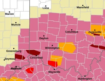
ZANESVILLE – A tornado warning has again been extended. This time, from 3:30 p.m. to 4, according to the National Weather Service.
The NWS confirmed the extension for southeastern Muskingum County and southwestern Noble County

At 3:30, a severe thunderstorm capable of producing a tornado was located 12 miles south of New Concord, or 15 miles southeast of Zanesville, moving east at 40 miles per hour, the NWS said.
Locations that could possibly be impacted include Caldwell, Dudley, Belle Valley, Sarahsville, High Hill, Ruraldale, Wolf Run State Park and Blue Rock State Park, the NWS said.
Rotation was detected by radar, the NWS confirmed. Hazards potentially not just a tornado but ping pong ball-sized hail, the NWS listed.
“Flying debris will be dangerous to those caught without shelter. Mobile homes will be damaged or destroyed. Damage to roofs, windows and vehicles will occur. Tree damage is likely,” the NWS noted.
The warning was first detailed by Muskingum County EMA at 2:36 and confirmed by the NWS at 2:37.
“Move to an interior room on the lowest floor of a well-built building away from windows. If you are outdoors, in a mobile home, or in a vehicle, move to the closest substantial shelter and protect yourself from flying debris, the NWS recommended.
There’s also a flash flood warning until 5:30 in Muskingum County, southwestern Guernsey County and northwestern Noble County, according to the NWS.
This article originally appeared on Zanesville Times Recorder: Tornado warning extended again for Muskingum, Noble counties
Reporting by Shawn Digity, Zanesville Times Recorder / Zanesville Times Recorder
USA TODAY Network via Reuters Connect
By Shawn Digity, Zanesville Times Recorder | USA TODAY Network