Temperatures are expected to dip again this weekend as thunderstorms move through Illinois, bringing another end to the brief spell of sunshine and 70s. This serves as a reminder that even in early April, spring can still bring sporadic weather shifts.
Climate Prediction Center forecasts point to a gradual warming trend as the influence of the fading polar vortex continues to wane. While brief cool-downs remain possible, models show temperatures trending closer to — and in some areas above — normal over the coming weeks.

At the same time, an active storm track will bring periodic rain and unsettled weather across the Ohio Valley, especially through mid-April. That mix of warming temperatures and intermittent systems suggests Illinois’ frost season is nearing its end, though isolated freezes may still occur in colder pockets.
When will the last freeze be in Illinois?
Records kept by the Illinois State Climatologist show that residents in Boone, McHenry, DeKalb and Kane counties can expect their last spring freeze around May 25, while those in the rest of northeast Illinois can expect it around May 15-20.
The average last freeze in central Illinois tends to land between April 30 and May 15, while southern Illinois’ will land around April 20-25, the site reports.
According to the Old Farmer’s Almanac, these are the average dates for the last frost in major cities across Illinois:
Illinois weather forecast for April
April will bring a mix of lingering chilly snaps and gradually warming conditions. Weather systems fueled by Gulf moisture, mid-level ridges, and cold fronts will keep rain, storms and occasional flooding possible across parts of the U.S.
Here’s what’s in the forecast week by week:
April 10-13 weather forecast
Late this week, a trough of low pressure over the western U.S. will keep weather active across much of the Ohio Valley, including Illinois. Expect scattered showers and thunderstorms, with the potential for periods of steady rain rather than one single event, according to the Climate Prediction Center.
While the heaviest rainfall focus is expected farther south — across the Southern Plains and Lower Mississippi Valley — Illinois and surrounding states could still see localized flooding, especially if storms repeatedly move over the same areas.
Temperatures in the Midwest will remain a bit below normal, thanks to lingering cool air from the waning polar vortex, which will turn into a mix of cool and unsettled weather early in the week.
April 14-20 weather forecast
By mid-April, the pattern across the Ohio Valley, including Illinois, tilts warmer and wetter than normal, even as storm systems continue to move through, according to the Climate Prediction Center.
The key period remains Tuesday–Wednesday, April 14–15, when a developing low-pressure system is expected to bring widespread rain and gusty winds. Forecast guidance supports above-normal precipitation overall, with many areas likely picking up around an inch of rain or more over several days. That raises the risk for localized flooding, especially where heavier rain bands set up.
At the same time, temperatures are expected to trend above normal, signaling a shift away from the recent cooler pattern. That added warmth will help fuel a more active storm track, keeping conditions mild but unsettled rather than cold and stormy.
Winds may also increase ahead of the system, with periods of gusty conditions possible Tuesday into Wednesday, though current signals point to more of a nuisance wind setup than a widespread damaging event.
Late April (April 18-May 1) weather forecast
Looking toward the second half of April, there’s no strong temperature signal for the Ohio Valley, including Illinois, meaning conditions could swing either side of normal at times. That fits a typical spring setup, with variability from passing systems rather than a locked-in warm or cool pattern.
Precipitation is also less certain. Unlike the Southwest, where a wetter-than-normal signal is clearer, the Ohio Valley falls into an “equal chances” zone, meaning there’s no strong lean toward wetter or drier than average overall.
That said, “equal chances” doesn’t mean quiet. It points to a pattern where periodic systems still bring rounds of rain, but without a clear signal for prolonged wet or dry stretches. In other words, expect typical spring variability — mild swings in temperature and occasional rain chances — rather than extremes.
Illinois spring weather forecast
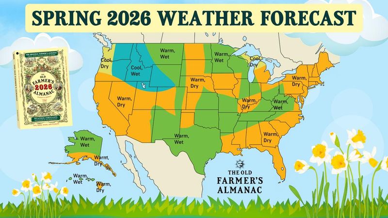
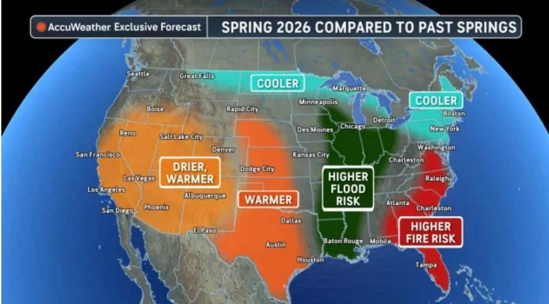
Both AccuWeather and the Old Farmer’s Almanac suggest that spring 2026 will be a season of contrasts across the U.S. The northern and eastern states are expected to experience a slower transition to spring warmth, with lingering cool spells, late-season frost and even the occasional snow.
Both forecasts highlight the potential for flooding across the Mississippi and Ohio River valleys due to a combination of spring rains and snowmelt.
Specifically in Illinois, the Old Farmer’s Almanac forecasts a split between warm, wet weather in northeast and central Illinois and warm, dry weather in the western and southern parts of the state.
Central Illinois weather radar
Chicago weather radar
Sign up for weather alerts with USA TODAY
This article originally appeared on Journal Star: How rainy will this spring be in Illinois? See weekly forecasts for April
Reporting by Hannah Hudnall and Brandi D. Addison, Peoria Journal Star / Journal Star
USA TODAY Network via Reuters Connect