Elevated fire danger. Storms. Gusty winds. Above-normal temperatures including heat index approaching 100.
Florida’s weather for the rest of the week and into the weekend will keep residents on their toes.

Showers started moving into the western Panhandle Tuesday night and are forecast to move across North Florida April 29. Storms have the potential of bringing up to a half-inch of rain, along with damaging winds and hail but are expected to weaken as they approach Northeast Florida.
The system is forecast to stall across North-Central Florida April 30, according to the Florida Division of Emergency Management.
➤ Weather alerts via text: Sign up to get updates about current storms and weather events by location
Associated rain, while bringing welcome relief to drought-stricken Florida, won’t be enough to counter months of little to no rain.
Ahead of the system Central and Southern Florida will see unseasonably warm temperatures. Highs in the interior are forecast to reach the lower 90s, with the heat index getting as high as 100 by April 30.
Here’s what to expect.
Rain coming to some portions of Florida this week, into weekend
The threat for severe storms was expected to diminish by daybreak April 29 in the Panhandle, but rain chances are forecast to increase across North Florida after sunset.
Storm impacts include the possibility of damaging winds and hail, along with up to 0.5 inches of rain, according to the Florida Department of Emergency Management.
Storms are expected to weaken as they approach Northeast Florida before the front boundary stalls across North-Central Florida early April 30.
Scattered showers — 40%-50% chance — are expected across North Florida April 30 and isolated storms — 20%-30% chance — in Central and South Florida, according to the Florida Department of Emergency Management.
A system of low pressure over the Gulf of America is forecast to move east across portions of Florida May 1-2.
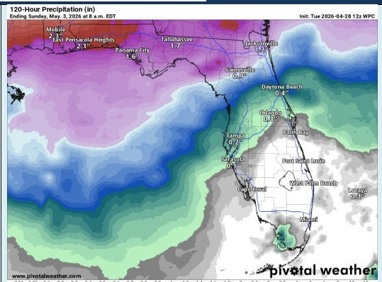
By May 2, rain chances increase for the Panhandle and North Florida. Rain chances will increase considerably (50-80%). Damaging winds, large hail, and a few tornadoes will be possible, along with 1-2 inches of rain and isolated amounts of 4 inches possible.
By late May 2, rain will spread into Central Florida, with rainfall amounts approaching an inch and more rain expected to continue beyond Saturday across Central and South Florida, according to the Florida Department of Emergency Management.
Florida temps climbing into 90s, with heat index even higher
Ahead of the front, Central and Southern Florida will see unseasonably warm temperatures, with high temperatures across interior areas reaching the lower 90s.
With increasing humidity after April 29, heat indices in the upper 90s to 100 degrees can be expected in the afternoon April 30, according to the Florida Division of Emergency Management.
Weather alerts issued in Florida
When will it rain in Florida?
Radar shows storms moving through Florida, Southeast
How hot will it get in Florida this weekend, May 2-3?
Current drought conditions in Florida
➤ Follow National Weather Service Mobile on X
Stay informed. Get weather alerts via text
What’s next?
We will provide weather coverage as conditions warrant. Download your local site’s app to ensure you’re always connected to the news. And look for our special subscription offers here.
Cheryl McCloud is a journalist for the USA TODAY Network-Florida’s service journalism Connect team. You can get all of Florida’s best content directly in your inbox each weekday day by signing up for the free newsletter, Florida TODAY, at https://palmbeachpost.com/newsletters.
This article originally appeared on Florida Today: Storms. Heat. Gusty winds. Florida weather has it all this week
Reporting by Cheryl McCloud, USA TODAY NETWORK – Florida / Florida Today
USA TODAY Network via Reuters Connect