
Spaghetti models June 17 are in consensus in keeping Potential Tropical Cyclone One — or Tropical Storm Arthur if it strengthens as expected — north of Florida.
That doesn’t mean the Sunshine State won’t feel any impacts, so it’s always important to make sure you’re prepared. Here is a list of supplies you should have for the season.

➤Track Potential Tropical Cyclone One
Flood watches were in effect early June 17 across parts of the Panhandle, with up to seven inches of rain associated with the system expected. Some areas could see more than 10 inches.
Shop Amazon for hurricane prep
The western Panhandle also faces a potential for tornadoes associated with the system.
➤ Weather alerts via text: Sign up to get updates about current storms and weather events by location
Here’s the latest advisory from the National Hurricane Center as of 5 a.m., June 17:
Highlights on what Potential Tropical Cyclone One is doing now
Special note on the NHC cone: The forecast track shows the most likely path of the center of the storm. It does not illustrate the full width of the storm or its impacts, and the center of the storm could travel outside the cone. In 2026, the Hurricane Center will experiment with a new cone to include 90% of forecast track possibilities instead of the previous 67% forecast error.
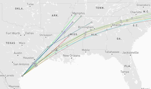
Spaghetti models for Potential Tropical Cyclone One
➤ Track Potential Tropical Cyclone One
Special note about spaghetti models: Illustrations include an array of forecast tools and models, and not all are created equal. The Hurricane Center uses only the top four or five highest performing models to help make its forecasts.
Is Florida in the path of Potential Tropical Cyclone One?
No, but remember, the path and strength of a storm can change rapidly. Remain vigilant and stay prepared.
➤ SMS weather alerts: Sign up now to stay informed via text on the latest developments in the tropics
We’ll continue to update stories regularly based on the latest forecasts and advisories.
Have any hurricane or tropical storm watches, warnings been issued for Florida?
No. As of 5 a.m. June 17, the following watches and warnings have been issued:
How strong is Potential Tropical Cyclone One and where is it going?
At 5 a.m., June 17, Potential Tropical Cyclone One’s maximum sustained winds were near 30 mph, with higher gusts.
Some strengthening is forecast, and the disturbance could become a tropical storm June 17. Weakening is anticipated once the low moves inland, and it could dissipate by tonight or early June 18.
The system was moving northeast at 6 mph and is expected to move northeast along the Texas coast June 17 and then move inland over southwestern Louisiana by tonight.
Stay informed. Get weather alerts via text
What’s next?
We will continue to update our tropical weather coverage to bring you the most current information you need to protect your home and family.
Cheryl McCloud is a journalist for the USA TODAY Network-Florida’s service journalism Connect team. You can get all of Florida’s best content directly in your inbox each weekday day by signing up for the free newsletter, Florida TODAY, at https://tallahassee.com/newsletters.
This article originally appeared on Tallahassee Democrat: See latest spaghetti models of Potential Tropical Cyclone One
Reporting by Cheryl McCloud, USA TODAY NETWORK – Florida / Tallahassee Democrat
USA TODAY Network via Reuters Connect
By Cheryl McCloud, USA TODAY NETWORK – Florida | USA TODAY Network