
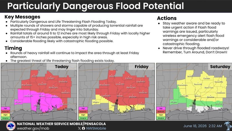
A rare high risk flood alert was issued by the Weather Prediction Center for areas of the far western Florida Panhandle with 6 to 12 inches of rain possible through Friday and isolated amounts of 15 inches or higher.
The National Weather Service is warning of particularly dangerous and life threatening flash flooding on Thursday, June 18 from the deluge brought by the remnants of Tropical Storm Arthur. Meteorologists called it a “multi-hazard high impact weather event.”

Arthur fell apart late Wednesday after briefly regaining a center of circulation near Galveston Texas. But showers and thunderstorms fizzled near its core and the circulation stretched along the Upper Texas Coast.
“Even though Arthur is no longer a tropical cyclone, heavy rainfall and life-threatening flash flooding will continue to be a major hazard for the next few days across the southeastern United States,” hurricane center forecasters wrote. “There is also an increased tornado threat for portions of the southeastern U.S. through Thursday.”
The areas of highest risk in Florida include Santa Rosa, Escambia and Okaloosa counties.
Kimberly Miller is a journalist for the USA TODAY NETWORK FLORIDA. She covers weather, the environment and critters as the Embracing Florida reporter. If you have news tips, please send them to kmiller@pbpost.com. You can get all of Florida’s best content directly in your inbox each weekday by signing up for the free newsletter, Florida TODAY, at palmbeachpost.com/newsletters.
This article originally appeared on Pensacola News Journal: Rare high risk alert for rainfall issued for Panhandle, 15 inches possible
Reporting by Kimberly Miller, Palm Beach Post / Pensacola News Journal
USA TODAY Network via Reuters Connect
By Kimberly Miller, Palm Beach Post | USA TODAY Network