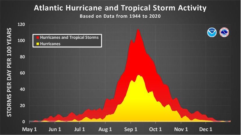
Hurricane season is at its peak, a time traditionally when tumult reigns in the Atlantic basin, tropical waves bristle with Cat 5 ambitions, seas heave and clouds tower.
Except this year, all is docile, serene, tranquil in the main runway for storm activity between Africa and the Caribbean.

Although a tease of a wave shot up to a 90% chance of formation last week with summer-warmed seas goading a tropical cyclone to form, so-called Invest 91L’s odds plummeted to zero 24 hours later. Forecast models misread the atmosphere. Meteorologists were flummoxed.
“This is one of the cases where we got it wrong, but also don’t have a clear explanation as to why,” said WPLG-TV hurricane expert Michael Lowry in a Sept. 8 column.
And as Sept. 10 arrives — the calendrical pinnacle of the June 1 through Nov. 30 storm season — no tropical activity is expected over the next seven days, according to the National Hurricane Center.
If that forecast holds true, it will be only the second time since 1950 that there are no named storms in the Atlantic between Aug. 29 and Sept. 15, according to Colorado State University senior research scientist Phil Klotzbach.
The other time was in 1992 just after Category 5 Hurricane Andrew.
Last year, there was a nearly four-week lull between the Aug. 12 formation of Hurricane Ernesto to Sept. 9’s formation of Francine, but to have nothing brewing during the peak of the season is unusual.
“This is super rare,” Klotzbach said. “We haven’t had a storm in the Atlantic since Fernand dissipated on Aug. 28.”
Six named storms have formed so far this season including one hurricane. That’s two named storms and two hurricanes fewer than the average for this time of year, according to CSU. The average dates of the third and fourth hurricanes each year are Sept. 7 and 16.
Because of Hurricane Erin’s strength and duration last month — it grew to a 160-mph Cat 5 and lived for 12 days as a tropical cyclone — the accumulated cyclone energy, or ACE, for the season is about 70% of average.
Meteorologists had pointed to the second week of September for an uptick in tropical activity as the Madden-Julian Oscillation, or MJO, moved into a favorable position to kick-start storms. But it has so far proved impotent in stoking potential trouble.
Fox Weather hurricane specialist Bryan Norcross said, like last year, it’s not entirely clear why the season has stalled.
He pins part of the blame on the relentless wet weather pattern lodged over South Florida. A deep dive in the jet stream across the eastern United States, which Norcross said has turned into a “semipermanent” feature, is emboldening high pressure in the Atlantic.
High pressure typically means sinking air, cloudless skies, drier air and a stable atmosphere, which is the opposite of the ingredients needed to grow a hurricane. There is also a puff of cyclone-deterring Saharan dust drifting over the Atlantic, which isn’t common this time of year.
“When you have unusual weather in one place, you normally have complimentary unusual weather downstream,” Norcross said. “I don’t have any one thing to point to.”
This month, West Palm Beach has gotten 3.3 inches of rain through Sept. 8 as measured at Palm Beach International Airport. That’s .96 inches more than normal for early September, but there is still a 13-inch deficit for the year.
As of Sept. 2, about 44% of Palm Beach County was in moderate to severe drought despite the rainy season beginning officially on May 15. About 5% of the county was in extreme drought, which is the third level on a four-tier scale. A new report from the U.S. Drought Monitor will be released Sept. 11.
“This rain is beneficial,” said Miami-based National Weather Service meteorologist Sammy Hadi, who cautioned against dismissing the rest of the hurricane season.
“Meteorology isn’t always black and white,” Hadi said. “The atmosphere is fluid.”
Lull in 2024 followed by an especially mean final hurricane season stretch
The storm lull of 2024 was followed by 12 named storms that formed after Sept. 10. Seven hurricanes formed in the Atlantic after Sept. 25 — the most on record for that period, according to the National Oceanic and Atmospheric Administration.
Hurricanes Helene and Milton made landfall on the Gulf Coast on Sept. 26 and Oct. 9.
Two tropical storms and major Hurricane Rafael formed in November.
Norcross noted that the Central American Gyre, which was the birthplace of several devastating Florida hurricanes such as Helene and Milton, as well as 2022’s Ian and 2018’s Michael, is active in the early and latter days of the season.
The gyre can spin storms into the Gulf of Mexico, now referred to as the Gulf of America by the U.S. government. Sea surface temperatures in the Gulf are between 3 and 7 degrees warmer than normal, providing ample fuel for a budding system.
“Florida’s hurricane season really is the very end of August, September and October but we’ve had Florida storms all the way to Thanksgiving,” Norcross said.
In 2022, Hurricane Nicole made landfall near Vero Beach on Nov. 10 as a Category 1 storm, and in 1985, Hurricane Kate came ashore four days before Thanksgiving near the Panhandle’s Mexico Beach.
This year also marks the 20th anniversary of Hurricane Wilma, which made landfall in southwest Florida as a Category 3 hurricane on Oct. 24. It whipped through the southern Peninsula in 4.5 hours, exiting into the Atlantic near Jupiter.
“We can’t let the current quiet fool us,” Hadi said. “People should remain prepared.”
Kimberly Miller is a journalist for The Palm Beach Post, part of the USA Today Network of Florida. She covers real estate, weather, and the environment. Subscribe to The Dirt for a weekly real estate roundup. If you have news tips, please send them to kmiller@pbpost.com. Help support our local journalism, subscribe today.
This article originally appeared on Palm Beach Post: It’s the peak of the 2025 hurricane season, so where are the storms?
Reporting by Kimberly Miller, Palm Beach Post / Palm Beach Post
USA TODAY Network via Reuters Connect