
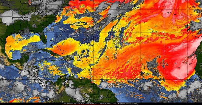
Another slug of Saharan air filters into Florida this week, dampening rain chances in the burning southern reaches of the state and contributing to a tropical cyclone hibernation that may last well past the July 4 holiday.
Weather Trader meteorologist Ryan Maue said the Atlantic basin was heading into a “slumber” after the short-lived but soggy Tropical Storm Arthur doused the Gulf Coast, while Colorado State University hurricane researcher Phil Klotzbach suggested now would be a good time to go on holiday.

“There is just a massive wall of wind shear and lots of dust, so, everybody go on vacation,” Klotzbach joked. “It looks really quiet after that junk in the Gulf. Arthur looks to be it for a while.”
National Weather Service meteorologists in Key West forecast rain chances near “nil” at least through Wednesday as the pocket of Saharan air drifts west from the Bahamas, eventually moving into the Gulf.
Does Saharan dust increase Florida temperatures?
And Miami-area meteorologists said “heat will remain a problem,” as Saharan dust is introduced into the mix and heat index or “feels like” temperatures climb into the 105 to 110 range.
West Palm Beach reached an ambient temperature of 96 degrees on Sunday, that’s seven degrees warmer than normal and tied the record daytime high set in 2009 for that day. At the same time, rain chances are at just 10% at least through mid-week as three wildfires continue to burn in Miami-Dade County consuming 22,000 acres.
“We do balloon launches twice a day and the dust is already oozing in here,” said NWS meteorologist Bryce Tyner, who is based in Key West. “We start getting these plumes June through July and it should limit hurricane activity for quite some time.”
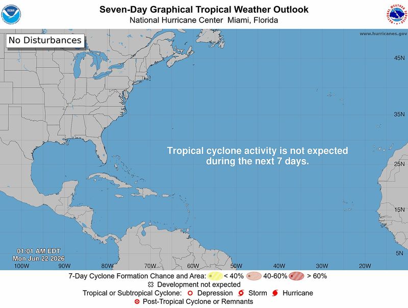
The National Hurricane Center has no tropical development in the forecast for the next seven days but that could stretch past the Fourth of July and into the middle of next month, said AccuWeather long-range forecaster Chad Merril.
In addition to the dry Saharan air and storm-throttling wind shear in the runway between the Africa and the Caribbean, is that a globe trotting pulse of energy called the Madden Julian Oscillation, or MJO, is moving into the western Pacific away from any stirrings in the Atlantic.
The MJO can instigate storm formation by causing air to rise.
“Everything is going to be pretty quiet for the next couple of weeks in the Atlantic,” Merril agreed.
Kimberly Miller is a journalist for the USA TODAY NETWORK FLORIDA. She covers weather, the environment and critters as the Embracing Florida reporter. If you have news tips, please send them to kmiller@pbpost.com. You can get all of Florida’s best content directly in your inbox each weekday by signing up for the free newsletter, Florida TODAY, at palmbeachpost.com/newsletters.
This article originally appeared on Palm Beach Post: Hurricane season slumbers as dust, shear quiet Atlantic turbulence
Reporting by Kimberly Miller, USA TODAY NETWORK – Florida / Palm Beach Post
USA TODAY Network via Reuters Connect
By Kimberly Miller, USA TODAY NETWORK – Florida | USA TODAY Network