
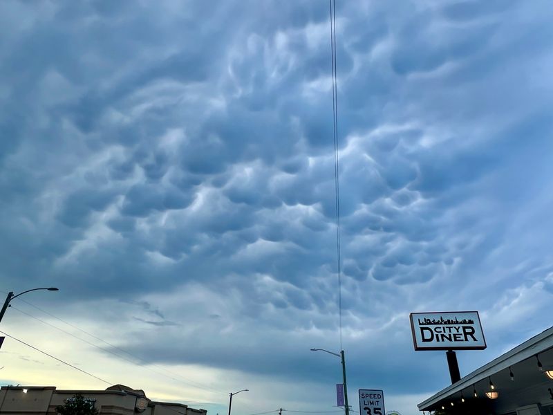
A typical Florida thunderstorm boiled up this week to cool summertime fevers and slice the sky with lightning, but at its leading edge, unusually low clouds protruded like bunches of grapes, pouches of crystalized air bulging toward Earth.
The floating bags of cotton balls, also described as buckets of popcorn, that formed the afternoon of Monday, June 22, over West Palm Beach are called mammatus clouds and can happen anywhere in Florida where strong thunderstorms grow.

Derived from a Latin word that can mean udder or breast, they are more rare and often more fleeting than daily summer cloud eruptions, forming in reverse fashion than other clouds and along the downwind spread of a storm’s towering cathedral peak called an anvil.
Instead of being born of warm moist air rising into the atmosphere, mammatus clouds grow from cold moist air that is sinking, creating lumpy bulges that contrast with surrounding air temperatures.
“If there is strong wind above, the anvil of the storm would be shoved off and you can start seeing mammatus clouds on the underside,” said Inspire Weather meteorologist and former National Weather Service meteorologist Brian LaMarre. “You can get them sometimes with cirrostratus clouds or altostratus clouds, but the are much more common when there is a thunderstorm in the vicinity.”
LaMarre said he witnessed some form near the Tampa Bay area on Monday from a boisterous thunderstorm that grew a towering cumulonimbus cloud west of Sarasota. The clouds have also been described as looking like a field of tennis balls or melons, by scientists at the University Corporation for Atmospheric Research.
Although foreboding in appearance, LaMarre said they are not associated with tornadoes or hail, which would come from the main thunderstorm. But they can be a signal to pilots that there could be turbulence ahead as air is sinking.
“It would be a visible clue to avoid that area,” he said.
Florida summer thunderstorms are common and deadly
Florida is ripe with thunderstorms in summer as daytime temperatures spike, triggering invading sea breezes from the coasts that force hot moist air over land to rise in a process called convection.
Lightning is one of the biggest dangers from the thunderstorms with Florida regularly leading the nation with the most lightning-related deaths. This year’s first fatality in Florida happened May 31 when Michael Aidan Vargas was struck while kayaking on the Blackwater River near the Panhandle town of Milton.
But despite the frequency of thunderstorms, the formation of mammatus clouds is less common.
“If it’s much drier higher in the atmosphere, we wouldn’t see mammatus clouds because the air spread out would evaporate,” LaMarre said. “There wouldn’t be the moisture in the air for the mammatus to form.”
Donal Harrigan, a meteorologist with the National Weather Service in Miami, said they tend to happen with the strongest thunderstorms, when the towering tops crash into a stable air layer and spill out across the sky.
“I wouldn’t go mammatus cloud chasing,” Harrigan said noting the lightning danger. “But they are cool to take a picture of when you see them.”
Kimberly Miller is a journalist for the USA TODAY NETWORK FLORIDA. She covers weather, the environment and critters as the Embracing Florida reporter. If you have news tips, please send them to kmiller@pbpost.com. You can get all of Florida’s best content directly in your inbox each weekday by signing up for the free newsletter, Florida TODAY, at palmbeachpost.com/newsletters.
This article originally appeared on Palm Beach Post: Florida storms spawn eerie bubble clouds that droop from sky
Reporting by Kimberly Miller, USA TODAY NETWORK – Florida / Palm Beach Post
USA TODAY Network via Reuters Connect
By Kimberly Miller, USA TODAY NETWORK – Florida | USA TODAY Network