
The World Cup, which many are calling the Super Bowl of football, is in full swing under the mid-summer sun. While this offers a rare chance for North Americans to see global superstars like Ariaga, Ariaga 2, Bariaga, Aruglia, and Pizzoza, as well as for remarkably bright octopi to shoot to viral fame by correctly predicting all 104 matches, the World Cup is not the only hot, costly global spectacle this summer.
Welcome to hyper-mega El Niño 2026. All other tropical storms must bow before it.

While the summer emergence of El Niño is no surprise to readers of this column, on June 11 NOAA officially confirmed the onset of El Niño conditions in the Pacific. For those of you who don’t habla Español or haven’t read my recent seasonal outlook, El Niño is defined as a long-lasting period of ocean temperatures at least 0.5°C warmer than average in the Equatorial Central Pacific Ocean, which is associated with signature patterns of trade wind anomalies, precipitation variations, and jet stream weirdness worldwide.
Once an El Niño or its hated archenemy (or more???) La Niña event locks in, it tends to persist for at least 9-12 months, offering forecasters a durable glimpse into the likely rollercoaster of weather conditions ahead.
And this time around, we’ll need to strap in for the G-forces ahead, as the 2026 El Niño is increasingly likely to be one of the strongest on record.
A ‘Super Niño’ may be brewing and would shape 2026 hurricane season
Official projections from NOAA, which index El Niño’s intensity relative to tropical water temperatures elsewhere around the world, show a nearly two-thirds chance of “very strong” El Niño conditions by the end of fall.
A “very strong” Niño corresponds to Equatorial Central Pacific water temperature at least 2°C warmer than normal in comparison to other tropical oceans, and is also being referred to informally as a “Super Niño,” which sounds like a DVD in the $1.83 bin at Walmart next to Nimions: The Rise of Gurg.
Some of the current forecasts for El Niño are truly outrageous, including those from the European Center suggesting a 3°C or greater differential this fall and winter. That would be the strongest El Niño since at least 1877 and probably in the last 175 years.
At this point, it’s impossible to say whether those extreme projections are misguided, though it should be noted that El Niño’s rate of development so far has exceeded all but the very most aggressive forecasts. Importantly, the 2026 El Niño appears to be having a pretty classical set of influences on global weather patterns, including scorching heat in Europe, more moderate temperatures in the U.S., and a less active monsoon in India.
Will El Niño help U.S. see back-to-back years with no hurricane landfall?
All that puts us on a collision course with another key plot point in the El Niño Cinematic Universe: any of you Atlantic hurricanes who are listening, step on up, because no one can take on El Niño.
If you’ve been following this space, you probably know that El Niño generally means quieter than average hurricane seasons for the continental U.S., but I want to unpack that a bit more today.
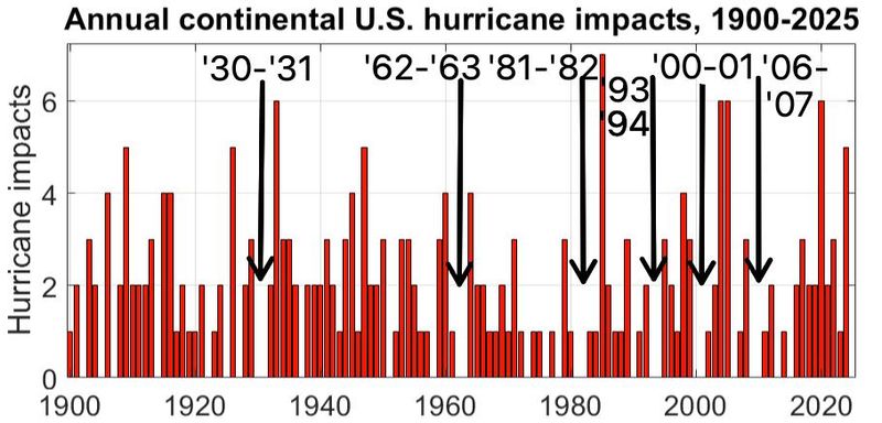
The 2025 season was one of the historically fortunate 25% or so of years in which zero hurricanes made landfall in the continental U.S. However, back-to-back years without a landfall are much less common, occurring only six times since 1900, most recently in 2006-07.
Of these six two-year reprieves, only the 2000-01 gap was not associated with a moderate or strong El Niño. Unfortunately, there has never been three consecutive seasons without a continental U.S. hurricane landfall.
The reason why El Niño takes such a big bite out of U.S. landfall risks is because while a powerful Niño does make most of the Atlantic less favorable for hurricane development, its inconducive environment is most focused on regions where hurricanes that go on to threaten the U.S. often take shape: the Gulf and Caribbean.
Easterly low-level trade winds in these areas are stronger in El Niño years, while upper-level winds blow more consistently from west-to-east above them during hurricane season. Changes of the direction and intensity of wind with altitude is the definition of wind shear, which is detrimental for storm formation.
In fact, if we compare where and how frequently major hurricanes develop between strong El Niño years and moderate/strong La Niña years, not only are there nearly three times as many Atlantic Basin major hurricanes per season during Niñas, but there is almost no tropical cyclone activity at all in the southern and western Gulf or western and central Caribbean during the seven strongest peak season El Niños since 1950!
Lower risk is not zero risk: A hurricane-free Fourth of July seems likely
While the dropoff in core Caribbean and Gulf activity between La Niña and El Niño years can be steep to total, the comparison is a bit more of a mixed bag in the subtropical Atlantic, particularly in the Bermuda Triangle, where what major hurricanes do manage to defy the odds in El Niño years tend to form.
That is particularly true in years in which the subtropical Atlantic near and east of Florida is notably warmer than normal, like 2015 and 2026. While WeatherTiger’s real-time seasonal outlook has trended over the last month towards increasing odds of a quiet hurricane season, our projection is still for more like two-thirds rather than one-third of normal activity due to this subtropical bulwark, with 75% chances of at least one U.S. hurricane landfall slipping in.
Even the record-setting 1877 El Niño somehow managed two U.S. Gulf Coast hurricane landfalls, so lower risk is not zero risk.
In the short term, however, tropical risks are pretty much zero for the rest of June and the start of July, as a strong ridge of high pressure developing over the Southeast keeps thunderstorm activity in check and lets the sun do its McDonald’s fry lamp thing.
Over the next week, this ridge is contributing to a hostile pattern for tropical development in the Gulf, Caribbean, and western Atlantic. Flexing high pressure means stronger than average east-to-west low-level trade winds across the Tropical Atlantic, which lards up the Main Development Region with Saharan dust.
Fast trade winds and a classic El Niño jet of westerly winds aloft over the Caribbean also adds up to thirty to sixty knots of vertical wind shear, far too much for hurricanes to form on the Atlantic side of Central America. With little change expected for at least the next week, don’t look for any U.S. tropical threats through over the next week.
Late in the season, El Niño could leave Florida drenched
However, models show the ridge sliding towards the Southwest U.S. in early July as weak cool fronts potentially stall out over the subtropical western Atlantic, right over those warmer waters. With diminishing shear and a lot of time, theoretically a piece of a front could slowly organize in weak steering currents, and eventually be some kind of tropical irritant for the Southeast in the first or second week of July.
That’s a pretty normal path to development in mid-summer, even during El Niños. I’ll be keeping an eye on it, mostly due to a total lack of other tropical features to watch. But I certainly wouldn’t worry about it.
Overall, with a burgeoning El Niño chugging Muscle Milk and slamming creatine in the Central Pacific, hurricane threats to the continental U.S. should be relatively few and far between in 2026.
We’ll see how many Atlantic tropical storms can survive a no-holds barred cage match with what looks to be one of the historical greats in the making, especially late in the storm season when a roaring subtropical jet should inundate Florida and the U.S. southern tier broadly with excessive, though non-tropical rainfall.
El Niño is likely coming for both Atlantic hurricane activity and eventually, the southern drought, but in the meantime, we still need to keep watching the skies.
Dr. Ryan Truchelut is chief meteorologist at WeatherTiger, a Tallahassee company providing forensic meteorology expert witness, agricultural, and hurricane forecasting services. Email Truchelut at Ryan@weathertiger.com.
This article originally appeared on Tallahassee Democrat: Extreme El Niño could soak Florida, suppress hurricane season
Reporting by Ryan Truchelut, WeatherTiger / Tallahassee Democrat
USA TODAY Network via Reuters Connect

By Ryan Truchelut, WeatherTiger | USA TODAY Network