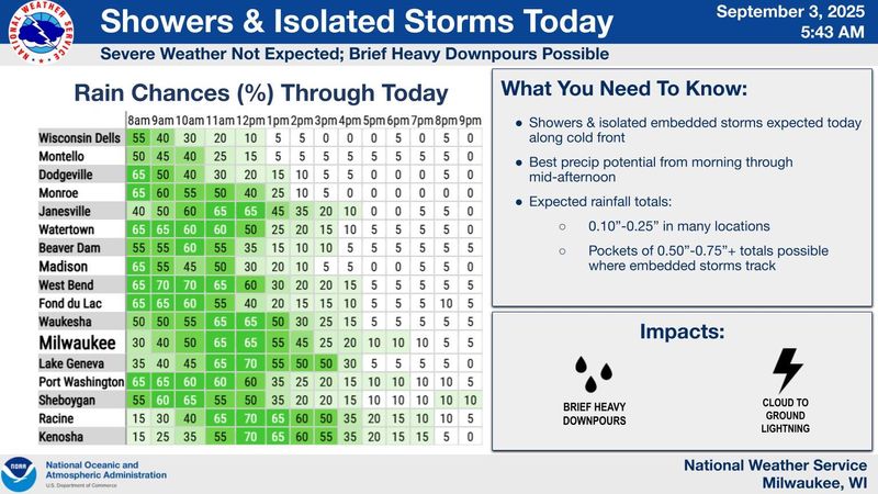
Wednesday’s rainy morning is the leading edge of a cold front entering the Milwaukee area.
Andrew Quigley, a meteorologist with the National Weather Service in Milwaukee/Sullivan, said most of the rain Sept. 3 will hit between around 9 a.m. and 11 a.m. He said southeast Wisconsin can expect light to moderate rain, with possible brief periods of heavy downpours, and some thunder and lightning.

Periods of lighter rain may continue into the afternoon, but the weather should turn dry by evening, Quigley said. Around that time and overnight into Thursday, Sept. 4, gusty winds from the northwest will carry in the colder temperatures.
The morning of Sept. 4 will see the coldest weather this week, with lows around 46 to 47 degrees in Milwaukee, Quigley said.
“Well below normal, but nothing that is looking to be record-breaking with this,” Quigley said. “But it will be chilly when you head out the door tomorrow morning, so definitely want to grab a light jacket.”
The low temperatures — about 10 to 15 degrees lower than average for early September — are expected to continue through the weekend. Temps should then “slowly rebound” at the start of next week, Quigley said.
Another round of rain and scattered thunderstorms is expected to hit Milwaukee and southern Wisconsin the evening of Sept. 4 through the morning of Sept. 5.
Contact Kelli Arseneau at (920) 213-3721 or karseneau@gannett.com. Follow her on Twitter at @ArseneauKelli.
This article originally appeared on Milwaukee Journal Sentinel: Rainy weather is the start of cold front coming through much of Wisconsin
Reporting by Kelli Arseneau, Milwaukee Journal Sentinel / Milwaukee Journal Sentinel
USA TODAY Network via Reuters Connect