Forecasters are expecting a wet start to the week.
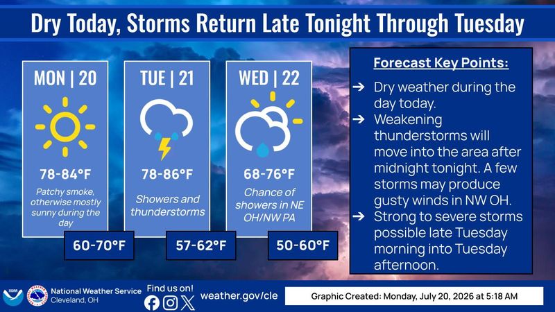
The National Weather Service’s Cleveland office is forecasting strong to severe thunderstorms throughout the week for Lake Erie, north central Ohio, northeast Ohio, northwest Ohio and northwest Pennsylvania.

Patchy smoke from the Canadian wildfires is expected to return July 20, but calm winds with a high near 82 are forecast. Tonight will be mostly cloudy, with a low around 66.
Here’s the weather for the rest of the week:
Tuesday: Showers and thunderstorms likely before 1 p.m., then showers and possibly a thunderstorm between 1-4 p.m., which will likely continue afterward. The high is near 81 and the evening low is 61. Southwest wind 10 to 15 mph, with gusts as high as 26 mph. Chance of precipitation is 90%. New rainfall amounts between a quarter and half of an inch possible. At night, showers and thunderstorms likely before 11 p.m., then a chance of showers from then till 2 a.m.
Wednesday: Partly sunny, with a high near 74. Northwest wind 9 to 11 mph, with gusts as high as 21 mph. At night expect mostly clear skies, with a low around 54.
Thursday: Sunny, with a high near 77. The evening will be mostly clear, with a low around 56.
Friday: Mostly sunny, 81 is the high. The evening forecast is partly cloudy, with a low around 60.
Saturday: Sunny, with a high of 84. At night, mostly clear, with a low around 63.
Sunday: Mostly sunny, with a high near 86.
This article originally appeared on The Repository: Expect stormy weather to start off the week in Canton
Reporting by Aaron Hughes, Canton Repository / The Repository
USA TODAY Network via Reuters Connect
By Aaron Hughes, Canton Repository | USA TODAY Network