An extreme heat watch is in effect Sunday-Tuesday for most of Ohio.
The northern half of the Buckeye State will have “dangerously hot conditions with heat index values up to 103 possible,” according to an urgent message published by the Cleveland office of the National Weather Service.

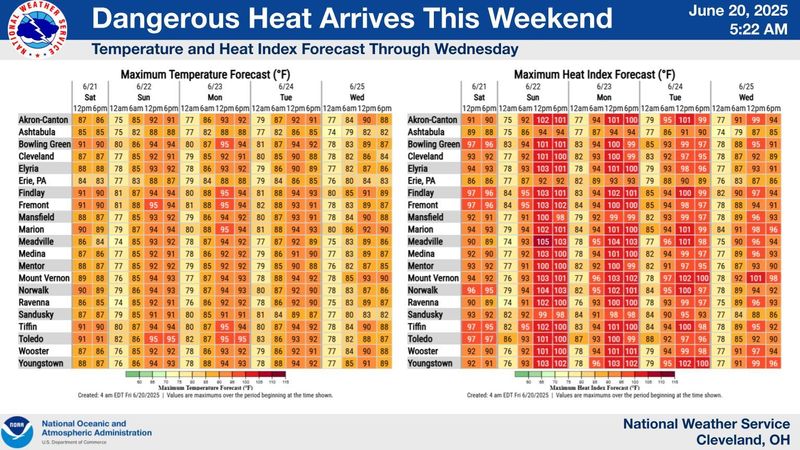
Highs in North Central Ohio are expected to hit 88 degrees on Saturday, 92 Sunday, 93 Monday, 93 Tuesday, 92 Wednesday, 88 Thursday and 88 Friday.
The Mansfield area is expected to be sunny with a high humidity most of the weekend and early next week.
“Heat-related illnesses increase significantly during extreme heat and high humidity events, particularly for those working or participating in outdoor activities,” the weather service noted. “Consecutive days of excessive heat and humidity combined with little relief overnight due to very warm low temperatures can be especially hazardous. The heat may continue into Wednesday.”
Ohioans are advised to drink plenty of fluids, stay in an air-conditioned room, stay out of the sun and check up on relatives and neighbors.
The extreme heat watch will be in effect Sunday morning through Tuesday evening for the following Ohio counties: Richland, Ashland, Crawford, Wayne, Marion, Holmes, Knox, Morrow, Ottawa, Sandusky, Erie, Ashtabula, Wyandot, Seneca, Huron, Lucas, Wood, Lorain, Cuyahoga, Lake, Geauga, Hancock, Medina, Summit, Portage, Trumbull, Stark and Mahoning.
ztuggle@gannett.com
419-564-3508
This article originally appeared on Mansfield News Journal: ‘Dangerously hot conditions’ coming to North Central Ohio
Reporting by Zach Tuggle, Mansfield News Journal / Mansfield News Journal
USA TODAY Network via Reuters Connect