Stark County is in story for another rainy week.

Storms are forecast nearly every day in the Akron-Canton area, with highs hanging in the high 70s and low 80s. The National Weather Service also issued a hazardous weather outlook for the Stark County area for conditions expected later this week.
“The Storm Prediction Center has northern Ohio and Northwest Pennsylvania in a Marginal risk (Level 1 of 5) and Northwest Ohio in a Slight risk (Level 2 of 5) for severe weather on (June 18),” according to the outlook.
Juneteenth will carry some showers as well, with a 60% chance of precipitation for the day. Showers are likely for most of the day, with thunderstorms becoming possible after 2 p.m.
What’s the forecast?
Here’s a look at the forecast or the week in the Akron-Canton area:
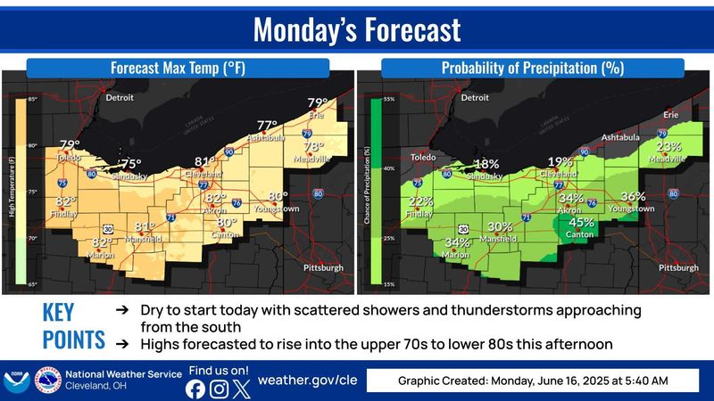
June 16: A chance of showers and thunderstorms, mainly after 3 p.m. Mostly cloudy, with a high near 80. East wind 3 to 5 mph. Chance of precipitation is 30%. New rainfall amounts between a tenth and quarter of an inch, except higher amounts possible in thunderstorms.
Evening: Showers and thunderstorms likely before 3 a.m., then showers likely and possibly a thunderstorm between 3 and 5 a.m., then a chance of showers after 5 a.m. Mostly cloudy, with a low around 67. Chance of precipitation is 60%. New rainfall amounts between a half and three quarters of an inch possible.
June 17: Showers and possibly a thunderstorm. High near 79. Southwest wind 6 to 8 mph. Chance of precipitation is 90%. New rainfall amounts between a tenth and quarter of an inch, except higher amounts possible in thunderstorms.
Evening: A chance of showers and thunderstorms before 2 a.m., then a slight chance of showers. Mostly cloudy, with a low around 68. Southwest wind around 7 mph. Chance of precipitation is 40%. New rainfall amounts of less than a tenth of an inch, except higher amounts possible in thunderstorms.
June 18: A chance of showers before 11 a.m., then a chance of showers and thunderstorms between 11 a.m. and 2 p.m., then showers likely and possibly a thunderstorm after 2 p.m. Partly sunny, with a high near 82. Southwest wind 7 to 10 mph. Chance of precipitation is 60%. New rainfall amounts of less than a tenth of an inch, except higher amounts possible in thunderstorms.
Evening: Showers likely and possibly a thunderstorm. Mostly cloudy, with a low around 69. Chance of precipitation is 60%. New rainfall amounts between a tenth and quarter of an inch, except higher amounts possible in thunderstorms.
Juneteenth: Showers likely, with thunderstorms also possible after 2 p.m. Partly sunny, with a high near 78. Chance of precipitation is 60%.
Evening: A chance of showers and thunderstorms before 8 p.m. Mostly clear, with a low around 61. Chance of precipitation is 30%.
June 20: Mostly sunny, with a high near 79.
Evening: Partly cloudy, with a low around 62.
June 21: Mostly sunny, with a high near 85.
Evening: Partly cloudy, with a low around 71.
June 22: Mostly sunny, with a high near 90.
This article originally appeared on The Repository: Canton area weather forecast: Storms and rain coming this week. Find out which days
Reporting by Janson McNair, Canton Repository / The Repository
USA TODAY Network via Reuters Connect