There’s an Air Quality Alert in effect for northern Ohio.

The Northeast Ohio Areawide Coordinating Agency says the air quality in a number of counties — including Summit, Medina, Portage and Wayne — may be unsafe for some residents.
The alert runs through Wednesday, June 4, as the air quality may be unsafe for sensitive groups.
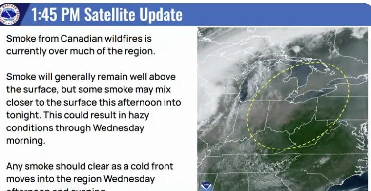
The culprit for the poor air quality over northern Ohio is rising temperatures along with smoke from the wildfires in Canada.
Hot and hazy conditions are expected until a storm front pushes through June 5, bringing bring rain showers and a thunderstorm or two.
The National Weather Service says storms on June 5 and 6 should help clear the air but have the potential to bring torrential rain along with the risk of flash flooding across the region.
What to do during the Air Quality Alert
Officials say residents can help reduce air pollution on June 3 and June 4 by doing the following:
Akron weather radar
What’s the weather forecast for Greater Akron?
Tuesday night: Widespread haze. Mostly clear, with a low around 65. South wind 8 to 10 mph.
Wednesday: Widespread haze before 2 p.m. Sunny, with a high near 87. Southwest wind 9 to 15 mph.
Wednesday night: Mostly cloudy, with a low around 68. South wind 5 to 9 mph.
Thursday: Showers and thunderstorms likely, then showers and possibly a thunderstorm after 11 a.m. High near 82. Southwest wind 6 to 8 mph. Chance of precipitation is 80%. New rainfall amounts between a tenth and quarter of an inch, except higher amounts possible in thunderstorms.
Thursday night: Showers and possibly a thunderstorm before 8 p.m., then a chance of showers and thunderstorms after 8 p.m. Low around 63. Northeast wind 3 to 5 mph. Chance of precipitation is 80%. New rainfall amounts between a tenth and quarter of an inch, except higher amounts possible in thunderstorms.
Friday: Showers likely and possibly a thunderstorm before 8 a.m., then showers likely between 8 a.m. and 11 a.m., then showers likely and possibly a thunderstorm after 11 a.m. Mostly cloudy, with a high near 78. Chance of precipitation is 70%. New rainfall amounts between a quarter and half of an inch possible.
Friday night: Showers likely and possibly a thunderstorm before 2 a.m., then a chance of showers. Mostly cloudy, with a low around 62. Chance of precipitation is 60%.
Saturday: A chance of showers before 2 p.m. Partly sunny, with a high near 75. Chance of precipitation is 30%.
Saturday Night: Partly cloudy, with a low around 55.
Sunday: Mostly sunny, with a high near 78.
Sunday night: A chance of showers. Partly cloudy, with a low around 60. Chance of precipitation is 40%.
Monday: Showers likely and possibly a thunderstorm. Partly sunny, with a high near 76. Chance of precipitation is 60%.
Monday night: Showers likely and possibly a thunderstorm. Partly cloudy, with a low around 58. Chance of precipitation is 60%.
Tuesday: A chance of showers and thunderstorms. Partly sunny, with a high near 74. Chance of precipitation is 30%.
Akron weather hourly
Need to know weather conditions by the hour? Make sure to check out our weather page here.
This article originally appeared on Akron Beacon Journal: Air Quality Alert: Heat and haze in Greater Akron weather forecast
Reporting by Craig Webb, Akron Beacon Journal / Akron Beacon Journal
USA TODAY Network via Reuters Connect