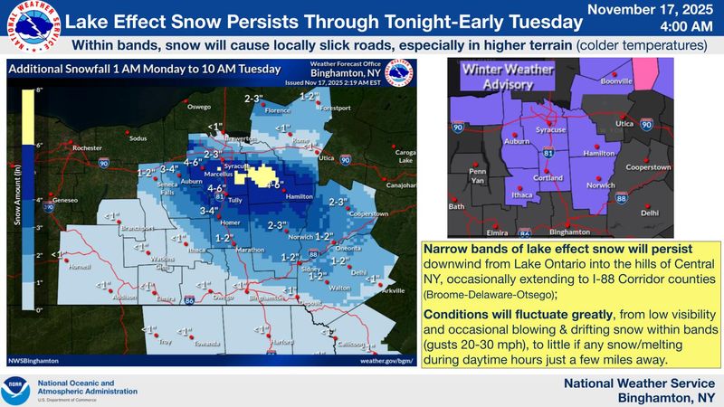
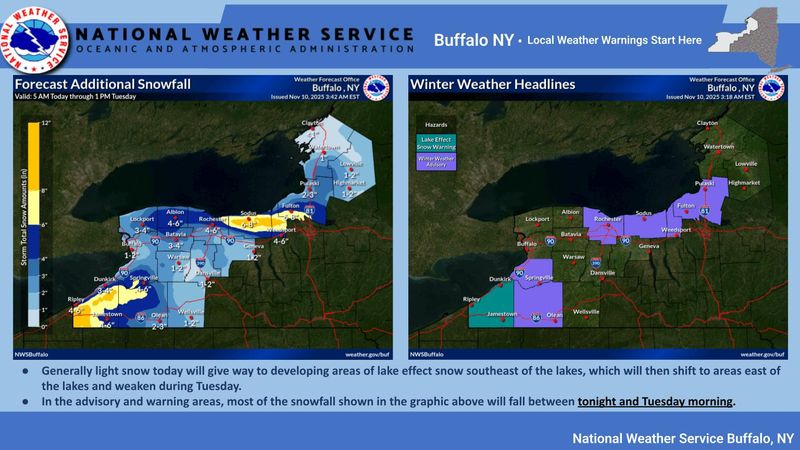
Lake-effect snow has returned to the Northeast and will continue across parts of western and central New York, creating slick conditions across much of the state Monday, Nov. 17.
The heaviest lake-effect snow bands are linked to a connection with Lake Huron, currently split into at least three separate bands, according to the National Weather Service office in Buffalo.

This connection is expected to shift southwest early Monday morning into northwest Pennsylvania and the southwest corner of Chautauqua County, then move back northeast across Chautauqua and Cattaraugus counties this afternoon before tapering to flurries and light snow showers tonight.
“Deep low pressure will continue to spin over the Canadian Maritimes today through tonight, allowing modest lake effect snow to continue southeast of the lakes along with some lingering upslope snow across the higher terrain east of Lake Ontario,” the National Weather Service wrote. “Accumulations will be limited, but may still produce slick travel in a few locations through Tuesday morning.
“High pressure will then build east across the Great Lakes region through midweek, bringing an end to lake effect along with seasonable temperatures,” the weather service wrote.
How much snow is still headed for New York?
Western New York, including Chautauqua and Cattaraugus counties, may see 1–3 inches through Monday, with isolated additional snowfall possible tonight. Areas near the lakeshore, including the New York State Thruway, are expected to see minimal accumulation due to slightly warmer surface temperatures.
Off Lake Ontario, snow showers are expected from Rochester east into the Finger Lakes, with a narrow band of 2–5 inches possible from far eastern Wayne County through northern Cayuga County into Tuesday morning. Meanwhile, upslope snow in the higher terrain of the Tug Hill Plateau and western Adirondacks will continue through Monday morning with 1–2 inches possible, tapering to flurries by evening.
New York weather watches and warnings
Stay informed. Get weather alerts via text
Brandi D. Addison covers weather across the United States as the Weather Connect Reporter for the USA TODAY Network. She can be reached at baddison@gannett.com. Find her on Facebook.
This article originally appeared on Rochester Democrat and Chronicle: Lake-effect snow returns to New York. See projected snowfall maps
Reporting by Brandi D. Addison, USA TODAY NETWORK / Rochester Democrat and Chronicle
USA TODAY Network via Reuters Connect