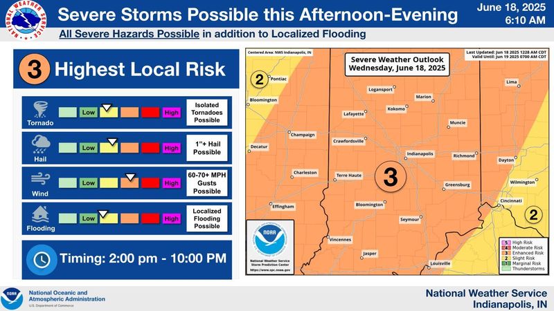
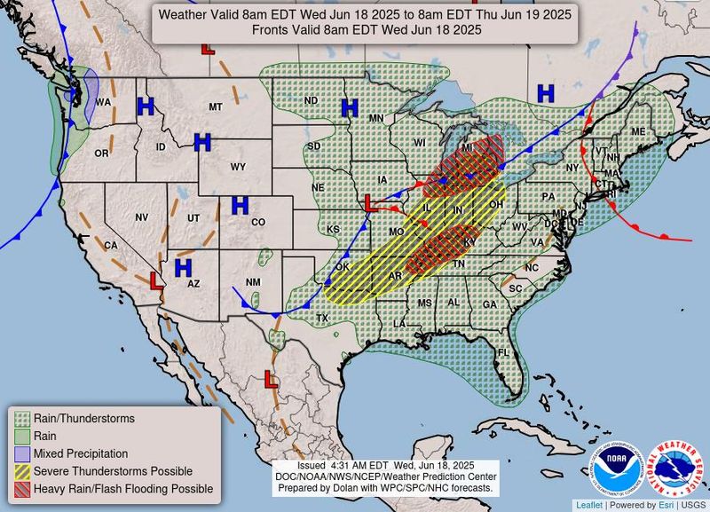
Several rounds of thunderstorms will hit Indiana on June 18, the National Weather Service warns.
The most intense storms are expected to occur between 2 p.m. and 10 p.m.

“This afternoon has the potential to be pretty interesting,” NWS meteorologist Earl Breon said.
Hail could be larger than an inch in some areas, and the chance of tornadoes can’t be ruled out. All the rain could lead to river and flash flooding, Breon added, so drivers should be mindful of low crossings on their routes.
There’s potential for wind above 70 mph, which could also create a serious hazard for drivers. Storms will continue until about 10 p.m., according to early June 18 models.
Indianapolis weather radar
Severe Thunderstorm warning issued for Greenwood, Columbus and Franklin
NWS Indianapolis announced a severe thunderstorm warning for Greenwood, Columbus and Franklin, which will be in effect until 5:15 p.m.
Severe Thunderstorm warning still in effect for Marion County
The Marion County Emergency Management announced a severe thunderstorm warning was still in effect for Marion County until 5:45 p.m.
Severe Thunderstorm warning issued for Carmel, Fishers and Anderson
NWS Indianapolis announced a severe thunderstorm warning for Carmel, Fishers and Anderson, which will be in effect until 5:45 p.m. The storm will contain wind gusts up to 70 mph.
Severe Thunderstorm warning issued for Indianapolis, Lawrence and Beech Grove – destructive storm
NWS Indianapolis announced a severe thunderstorm warning for Indianapolis, Lawrence and Beech Grove, which will be in effect until 5 p.m. This destructive storm will contain wind gusts up to 80 mph.
How to remember the difference between watches and warnings
To make it relatable, IndyStar created a handy graphic using the pork tenderloin sandwich.
A watch means the area has all the right ingredients to make a tenderloin sandwich, it’s just not assembled yet. With all the ingredients, a tornado could form within the area.
A warning means the sandwich is fully assembled (a tornado has been confirmed, or there’s a good enough chance that officials deem a warning necessary).
Tornado Warning issued for Hendricks, Boone and Marion County
The National Weather Service in Indianapolis announced a tornado warning for Hendricks, Boone and Marion County, which will be in effect until 4:45 p.m.
Severe Thunderstorm warning issued for Indianapolis – destructive storm
NWS Indianapolis announced a severe thunderstorm warning for Indianapolis, Lawrence and Plainfield, which will be in effect until 5 p.m. This destructive storm will contain wind gusts up to 80 mph.
Severe Thunderstorm warning issued for Kokomo, Frankfort and Lebanon
NWS Indianapolis announced a severe thunderstorm warning for Kokomo, Frankfort and Lebanon, which will be in effect until 4:30 p.m. The area is expected to be hit with penny-sized hail and 60 mph gusts of wind.
Severe Thunderstorm warning issued for Marion County
The Marion County Emergency Management announced a severe thunderstorm warning for Marion County, which will be in effect until 4:45 p.m.
Severe Thunderstorm warning issued for Bloomington, Bedford and Ellettsville
NWS Indianapolis announced a severe thunderstorm warning for Bloomington, Bedford and Ellettsville, which will be in effect until 4:45 p.m. The area is expected to be hit with nickel-sized hail and 70 mph gusts of wind.
A tornado is possible in the area, according to NWS Indianapolis.
Severe Thunderstorm warning issued for Washington, Linton and Bicknell
NWS Indianapolis announced a severe thunderstorm warning for Washington, Linton and Bicknell, which will be in effect until 4:15 p.m. The area is expected to be hit with quarter-sized hail and 70 mph gusts of wind.
A tornado is possible in the area, according to NWS Indianapolis.
Severe Thunderstorm warning issued for Plainfield, Brownsburg and Zionsville
NWS Indianapolis announced a severe thunderstorm warning for Plainfield, Brownsburg and Zionsville, which will be in effect until 4:45 p.m. The area is expected to be hit with penny-sized hail and 70 mph gusts of wind.
Tornado Warning issued for Rosesale, Fontanet and Catlin
NWS Indianapolis announced a tornado warning for Rosesale, Fontanet and Catlin, which will be in effect until 3:45 p.m. The area is expected to be hit with pea-sized hail.
Tornado Warning issued for Delphi, Flora, Camden and Yeoman
NWS Indianapolis announced a tornado warning for Delphi, Flora, Camden, Yeoman and Rockfield, which will be in effect until 3:45 p.m. The area is expected to be hit with pea-sized hail.
Tornado Warning for the Terre Haute region
NWS Indianapolis announced a tornado warning for Terre Haute, North Terre Haute and West Terre Haute, which will be in effect until 3:45 p.m. The area is expected to be hit with pea-sized hail.
Tornado Warning for Lafayette and West Lafayette
NWS Indianapolis announced a tornado warning for Lafayette, West Lafayette and Delphi, which will be in effect until 3:45 p.m. The area is expected to be hit with pea-sized hail.
Tornado Warning for Montezuma, Newport and Bloomingdale
NWS Indianapolis announced a tornado warning for Montezuma, Newport and Bloomingdale, which will be in effect until 3:15 p.m. The area is expected to be hit with quarter-sized hail.
Severe Thunderstorm for West Lafayette and Lafayette
NWS Indianapolis announced a severe thunderstorm warning for Lafayette, West Lafayette and Crawfordsville, which will be in effect until 3:45 p.m. The area is expected to be hit with quarter-sized hail and 70 mph gusts of wind.
Tornado Warning for Cayuga, Montezuma and Saint Bernice
NWS Indianapolis announced a tornado warning for Cayuga, Montezuma and Saint Bernice, which will be in effect until 3:15 p.m. The area is expected to be hit with ping pong-sized hail.
Hundreds of AES Indiana customers are still without power
After this morning’s storm, AES Indiana announced that 3,086 customers were without power after the city had been hit with severe weather.
By 2 p.m., AES Indiana announced that the company had returned power to all but about 670 customers still without electricity.
However, this announcement comes hours before the Indianapolis Metro area is expected to be hit with a second round of severe weather conditions, according to NWS Indianapolis.
Thunderstorms approaching state lines
NWS Indianapolis announced at about 2 p.m. that a second line of thunderstorms is approaching the Indiana stateline.
This round of storms is expected to bring heavy rain, gusty winds, large hail and tornado threats throughout the evening.
The storm is expected to move northeast once it crosses the state line.
Tornado watch issued for majority of Indiana as severe weather moves across states
NWS Indianapolis issued a tornado watch for parts of Illinois, Indiana, and Michigan until 8 p.m. A majority of the state, from South Bend to south of Bloomington, is under a tornado watch with a few tornadoes likely. Scattered hail the size of ping pong balls is also possible with wind gusts up to 75 miles per hour.
More than 3,000 without power
As of about 8:30 a.m., AES Indiana reported a severe thunderstorm left more than 3,000 customers without power. Most of the outages were concentrated on the south side of Indianapolis, according to the company’s outage map. The estimated time of restoration was 12:30 p.m.
Juneteenth and weekend forecast
The morning of Juneteenth will break with more showers and thunderstorms before 8 a.m. There’s a “slight” chance of showers between 8 a.m. and 11 a.m. on June 19, and then the stormy weather will resume.
This weekend is predicted to be simmering hot, with June 22, June 23 and June 24 expected to hit temperatures higher than 90 degrees.
Weather travel advisories
Weather info you need
Indiana Weather Alerts: Warnings, Watches and Advisories.
Indiana power outage map: How to check your status.
Internet outages: How to track them.
What you should and shouldn’t do when the power is out.
Your neighbor left their pet outside. Who you should call.
Where to report power outages and downed lines
How to report downed traffic signals or tree limbs blocking a road
If you encounter a downed traffic signal or a limb blocking a roadway, contact the Mayor’s Action Center at 317-327-4622 or online at RequestIndy.gov. When calling after hours, press “2” to be connected.
Indianapolis and Indiana road conditions
Check road conditions, including road closures, crashes and live webcams using Indiana’s online Trafficwise map at 511in.org, or visit our gridlock guide page for live traffic cams and more.
INDOT’s CARS Program provides information about road conditions, closures and width and weight restrictions. The website has a color-coded map of Indiana’s highways and highlights hazardous road conditions and travel delays.
The interactive map also shows road work warnings, closures, roadway restrictions and other information helpful to drivers.
Ryan Murphy is the communities reporter for IndyStar. She can be reached at rhmurphy@indystar.com. Jade Jackson is a Public Safety Reporter for the Indianapolis Star. You can email her at Jade.Jackson@IndyStar.com and follow her on X, formerly Twitter @IAMJADEJACKSON.
This article originally appeared on Indianapolis Star: A majority of Indiana under tornado watch. Here’s the latest forecast
Reporting by Ryan Murphy, Jade Jackson and Noe Padilla, Indianapolis Star / Indianapolis Star
USA TODAY Network via Reuters Connect