Monday and Tuesday are going to be hot and humid − much like every day for the past couple of weeks − but if you can hold out until Wednesday, you’re in for a stretch of pleasant days.
That’s the assessment from the National Weather Service as the Tri-State starts a week that’ll see a variety of conditions outside.

Here’s what forecasters are saying.
Hot and humid Monday and Tuesday
The summerlike heat and stifling humidity the region has been dealing with for a while now will continue on Monday and Tuesday. The high temperature on Monday likely will reach 90 degrees in Evansville, and Tuesday highs will soar into the mid 90s.
The rough part will be the humidity. The dewpoints Monday will top out in the middle 70s, creating a “feels like” temperature of 98 degrees.
It’ll be much worse on Tuesday.
The National Weather Service thinks the dewpoint will reach an oppressive 79 degrees, creating a “feels like” temperature ranging from 110 to 116 degrees.
The agency has issued an extreme heat warning for the Evansville/Henderson/Owensboro areas on Tuesday from 11 a.m. until 7 p.m.
Severe weather possible Tuesday
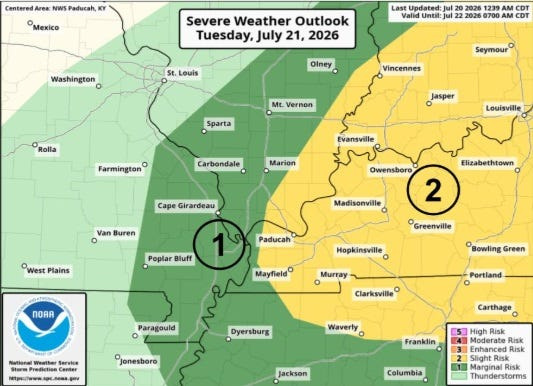
A cold front will move through the region later on Tuesday, and forecasters expect it to spark a line of storms that will move in from the north in the afternoon and evening hours.
The Storm Prediction Center has placed much of the area in a “slight risk” zone for severe weather on Tuesday. The main concerns are damaging winds and large hail, though there is also a small chance that the storms could spawn a tornado.
Some localized flooding is also possible, the weather service said.
Finally, some relief on Wednesday
Behind the cold front, high pressure “will offer much drier and cooler conditions Wednesday into Thursday,” the weather service said in a Monday morning briefing.
High temperatures will be in the lower 80s on Wednesday and upper 70s on Thursday. Dewpoints will be in the upper 50s to around 60 degrees, meaning the air will be much more comfortable.
Evansville weather radar
This article originally appeared on Evansville Courier & Press: Forecasters expecting storms, then a break in the heat this week
Reporting by Ryan Reynolds, Evansville Courier & Press / Evansville Courier & Press
USA TODAY Network via Reuters Connect
By Ryan Reynolds, Evansville Courier & Press | USA TODAY Network