
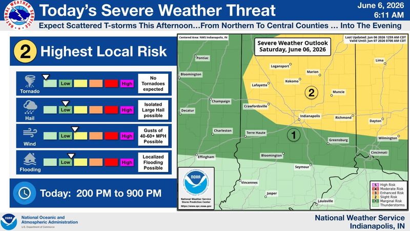
Hoosiers can expect strong storms Saturday evening, with threats of flooding, wind gusts up to 60 miles per hour and hail as large as one inch in diameter.
The National Weather Service has issued a severe thunderstorm watch covering 17 counties across central Indiana that will be in effect on June 6 until 10 p.m.

The hot and stormy weather weekend has already rained on the parade of some in central Indiana.
Just a day before its commencement ceremony, Ben Davis High School announced it would postpone graduation, originally scheduled for the evening of June 6, to the morning of June 7 due to “predicted lightning and an unstable atmosphere.”
The announcement, posted on Facebook, drew some adverse reactions from family of graduates and commenters on social media.
However, storms are expected for the evening of June 6, Indianapolis National Weather Service meteorologist Jason Puma said. The chance of afternoon and overnight storms in Indianapolis Saturday will rise to around 40% to 50%, Puma said. That number is higher for surrounding areas to the north. The chance of rain on Sunday is around 50%, he said.
Puma said Ben Davis leaders made the call to postpone the ceremony on their own.
“Those decisions are made by the officials in every high school,” he said. “We just provide the information, and the information right now shows there are chances for showers and thunderstorms — especially across northern and central parts of central Indiana — late this afternoon and into this evening.”
On Facebook, people planning to attend the commencement questioned the delay.
“Less then a 30% chance of bad weather. How many people had made UNCHANGEABLE PLANS to attend their kids Graduation,” one commented under the post. Others commented that they would no longer be able to make the ceremony due to a work or travel conflict.
Weekend conditions are expected to be warm and humid, with low temperatures around 70 degrees. There’s a chance for showers each day of the upcoming work week due to weather disturbances passing through the area, Puma said.
Storms are likely on Monday and Tuesday, with a 80% chance both days. The threat of rain dips to 40% on Wednesday, 20% on Thursday and 30% on Friday, Puma said, with highs expected to be in the mid-to-upper 80s all week.
Download the free IndyStar app and turn on notifications to get breaking news weather alerts.
Weather travel advisories
Weather info you need
Indiana Weather Alerts: Warnings, Watches and Advisories.
Indiana power outage map: How to check your status.
Internet outages: How to track them.
What you should and shouldn’t do when the power is out.
Where to report power outages and downed lines
How to report downed traffic signals or tree limbs blocking a road
If you encounter a downed traffic signal or a limb blocking a roadway, contact the Mayor’s Action Center at 317-327-4622 or online at RequestIndy.gov. When calling after hours, press “2” to be connected.
Indianapolis and Indiana road conditions
Check road conditions, including road closures, crashes and live webcams using Indiana’s online Trafficwise map at 511in.org, or visit our gridlock guide page for live traffic cams and more.
INDOT’s CARS Program provides information about road conditions, closures and width and weight restrictions. The website has a color-coded map of Indiana’s highways and highlights hazardous road conditions and travel delays.
The interactive map also shows road work warnings, closures, roadway restrictions and other information helpful to drivers.
Mia Thurow is the breaking news and criminal justice reporting intern for the Indianapolis Star. She can be reached at mthurow@gannett.com.
This article originally appeared on Indianapolis Star: Saturday evening could see severe storms with potential hail, flooding
Reporting by Mia Thurow, Indianapolis Star / Indianapolis Star
USA TODAY Network via Reuters Connect
By Mia Thurow, Indianapolis Star | USA TODAY Network