
Eighteen bridges cross White River within Muncie’s city limits: 12 for streets and highways, four for railroads and two for Cardinal Greenways.

Starting on Muncie’s far-southeast side and moving downstream, the road crossings are: INDOT twin bridges No. 1010 and 1020 (Bypass, 2003), Parker Moore (Memorial Drive, 1973), East Jackson (2019), Wysor Street (Broadway/MLK Jr., 1999), Elm Street (1991), Walnut Street (2003), Fallen Heroes (High St., 2005), West Washington (1930), West Jackson (2013), Nichols Avenue (1996) and Tillotson (2018).
Norfolk Southern Railway maintains four bridges across the White River in Muncie — at Beech Grove Cemetery, McCulloch Park and two along Bunch Boulevard. The lone CSX bridge crosses the river south of Kitselman Trailhead on Muncie’s east side.
My two favorite bridges in town are Pennsy Bridge at McCulloch Trailhead and Kitselman Bridge at Muncie’s soon-to-open Eastern Gateway.
The Pennsylvania Railroad erected Pennsy Bridge in 1916. It replaced a 1901 crossing that failed in the Great Flood of 1913. The bridge ran trains over the river until the early 1970s and then was abandoned. It reopened in 2023 as Cardinal Greenway’s White River crossing at McCulloch Trailhead.
Upstream, the magnificently restored Kitselman Bridge links White River Greenway and Cardinal Greenway at the new Eastern Gateway. The expanse was originally built in 1905 by Muncie’s own Indiana Bridge Company. It carried Strong Road over Mississinewa River south of Albany. The bridge was dismantled, restored and re-erected over White River as a trail bridge in 2020.
I couldn’t find build dates for the railroad bridges, but of the rest, Kitselman Bridge is the oldest active river span within Muncie’s city limits at 121 years old. All the road bridges replaced earlier crossings at the same locations. Even the 96-year-old West Washington Street Bridge is the third expanse to link Old West End and Riverside-Normal City neighborhoods at that spot.
We take Muncie’s bridges for granted. Our city sprawls on both sides of the river, traversable only because the bridges tie Muncie’s two halves together. Thousands of locals make the crossings daily to get to work, school and run errands. Muncie simply wouldn’t function without bridges.
Before them, travelers crossed the river at fords: shallow areas where the water was low enough for easy passage by horse and wagon. Muncietown’s principal ford was at present-day Fallen Heroes Bridge. It linked High Street on the village’s north end to the Richmond & Delphi Road (Wheeling and Bethel). When the river was high, a ferry operated upstream between North Walnut Street and Granville Road.
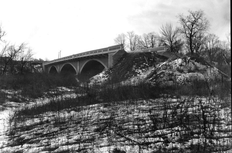
Each bridge has its own unique origin story. One of the most interesting is the Nichols Avenue Bridge. When it was completed in summer of 1925, it led nowhere and connected nothing. It sat unused for years while Center Township residents fought a tax dispute over improvements to Nichols Avenue.
In 1919, the city had annexed many gas-boom era suburbs, including Congerville, Riverside, Normal City (West Side), Whitely, Boycetown (Mayfield) and parts of Avondale. Muncie built new infrastructure into these neighborhoods, like sewers, street lighting and paved roads. Most bridges within the city’s new limits had already been built, the result of a county bridge-building boom around 1900.
But in the early 1920s, no bridge spanned the White River between West Jackson and Tillotson. Thousands of West Siders who worked in south-side factories, Avondalers employed on the north side and Southsiders attending Indiana State Normal School (Ball State), needed to cross the river daily. An 1890s trolley line into West Side was circuitous and mostly unused by the mid-1920s, as Munsonians began buying cars.
Commuters instead used either the West Jackson Street bridge, necessitating a slowed route through downtown, or made a trek out to the one-lane Tillotson Bridge in Muncie’s western boondocks.
Seeing the need, county commissioners ordered plans for a road bridge in early 1924. The winning bid went to the National Concrete Company of Indianapolis, which completed a two-lane expanse for $44,900 (about $830K today) in 1925.
But no road yet reached the bridge.
Batavia Avenue, Avondale’s main western thoroughfare, had been extended over the railroad tracks to Yorktown Pike (Kilgore Avenue), but not to the river. White River Boulevard had been planned north of the bridge but remained unbuilt west of Washington Street. Nichols Avenue ended a few hundred feet short of the river. An east-west, single-lane dirt road connected Nichols to Tillotson through then abandoned West Side Park.
At the time, Indiana’s Three-Mile Road Law allowed Hoosiers to petition their county or city governments for street improvements of less than three miles. Any costs were levied as taxes only within the affected township or municipality.
In September 1925, West Sider Henry Risher petitioned Delaware County commissioners to widen and extend Nichols Avenue from University to Yorktown Pike, over the bridge. Risher worked at General Motors in Avondale, while his wife, Alameda, kept books for Machinist Foundry on South Macedonia. Like thousands of other working Munsonians, both Rishers crossed the river daily.
The Rishers’ petition included about 3,000 signatures, roughly 9% of Center Township’s population in 1925. Local newspapers dubbed the project “Risher Road” in honor of Henry and Alameda. The avenue itself was named for salt magnate Alonzo Nichols, an early investor in the west-side development.
A remonstrance with 1,200 Center Township signatures was filed immediately, blocking the project. The effort was led by local veterinarian Dr. Farra Botkin, a Munsonian anti-taxer living in the old East End. Commissioners heard both sides at a hearing and overruled the remonstrators, but Botkin appealed.
The matter was held up in court for more than a year. After successfully filing for a change of venue in 1927, the case was eventually heard in a Randolph County circuit court at Winchester. The court ruled in favor of Risher Road in February 1928.
Nichols was then widened and paved between Gilbert Street and Yorktown Pike. Most of White River Boulevard was completed in the 1930s. On Muncie’s west side, it ran along the river’s north bank, from Wheeling Avenue to Godman. There it headed west to Nichols then turned south to the bridge.
The boulevard was poorly maintained for many decades but paved in the 1960s. It was rerouted along the river’s north bank between West Jackson and Nichols in 1965 and extended to Tillotson.
As for the original Nichols Bridge, the expanse was demolished by dynamite in the summer of 1996. The current bridge was built in about six months by Gohmann Asphalt and Construction of Clarksville, Indiana. It opened in early January of 1997 at a cost of $1.4 million (about $3 million today).
Like most bridges in Delaware County, the one at Nichols Avenue is maintained by the county, officially as County Bridge No. 504. If it stands as long as its predecessor, we’ll still drive over it in the 2060s.
Chris Flook is a Delaware County Historical Society historian and senior lecturer of media at Ball State University.
This article originally appeared on Muncie Star Press: ByGone Muncie: River crossings and the Nichols Bridge to Nowhere
Reporting by Chris Flook, Muncie Star Press / Muncie Star Press
USA TODAY Network via Reuters Connect
By Chris Flook, Muncie Star Press | USA TODAY Network