High rain chances are still forecast to be an unwelcome factor in Independence Day celebrations this week in Daytona Beach and surrounding areas as odds are increasing for development of a tropical disturbance over Florida, according to the latest update from the National Weather Service.
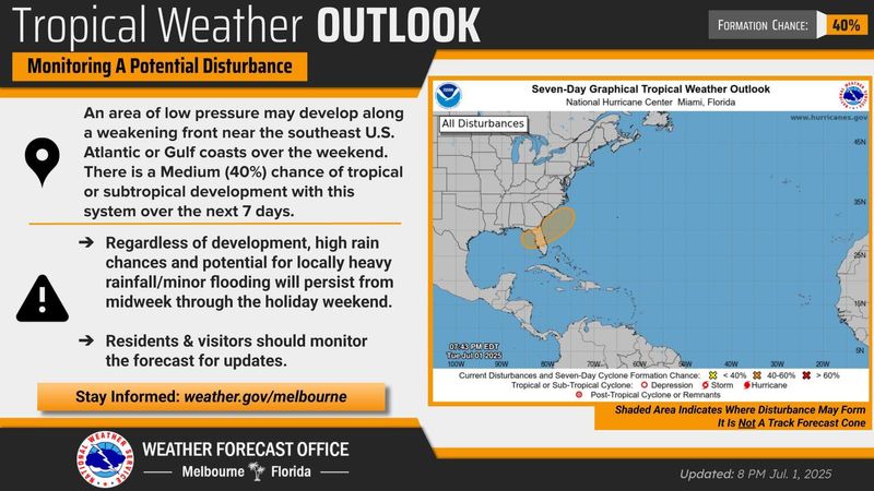
A tropical disturbance forecast to move across the Florida peninsula now has a medium (40% chance) of development along the southeastern Atlantic or Gulf coasts through the next seven days, according to the NWS.

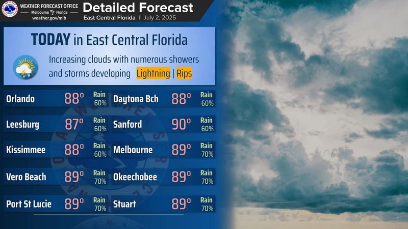
In the meantime, very high chances of showers and lightning storms are predicted through the rest of the week and into the weekend, according to the Wednesday, July 2, forecast discussion posted by the National Weather Service in Melbourne.
There’s a 60% chance of showers and thunderstorms on Wednesday, July 2, 80% on Thursday, July 3, and 70% on Friday, July 4, in both Daytona Beach and Palm Coast.
Greatest coverage generally is expected in the afternoon and evening, with higher than normal chances in the overnight and morning.
Rounds of showers and storms will increase the risk for minor flooding, especially for areas that receive locally high rainfall amounts multiple days in a row, the NWS states.
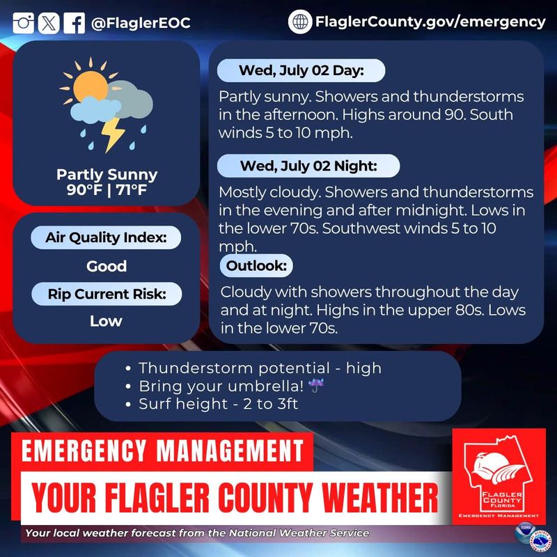
In Flagler County, showers and thunderstorms also are likely in the afternoon and evening hours, according to a Facebook post by Flagler County Emergency Management. The potential for severe thunderstorms also is high.
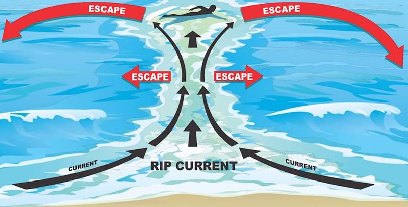
A moderate risk of rip currents also exists at all Atlantic beaches, including those in Volusia and Flagler, according to the National Weather Service.
Odds of tropical development increase, add to area storm chances
Meanwhile, a tropical disturbance forecast to move across the Florida peninsula now has a medium chance (40%) of developing along the southeastern Atlantic or Gulf coasts through the next seven days.
Regardless of development, high rain chances and potential for locally heavy rainfall and minor flooding will persist through the holiday weekend, according to forecasts.
Daytona Beach weather radar
Extended forecast for Daytona Beach
Wednesday, July 2: A 60% chance of showers and thunderstorms, mainly after 2 p.m. Partly sunny, with a high near 88 and nighttime low around 74. South southwest wind 5-10 mph. New rainfall amounts between a tenth and quarter of an inch, except higher amounts possible in thunderstorms.
Thursday, July 3: An 80% chance of showers and thunderstorms. High near 87, with nighttime low around 73. South southwest wind around 10 mph, with gusts as high as 20 mph. New rainfall amounts between a tenth and quarter of an inch.
Independence Day, Friday, July 4: A 70% chance of showers and thunderstorms, mainly after 2 p.m. Partly sunny, with a high near 86 and nighttime low around 74. South southwest wind 5-10 mph becoming east southeast in the afternoon, with gusts as high as 20 mph.
Saturday, July 5: A 70% chance of showers and thunderstorms. Partly sunny, with a high near 85 and nighttime low around 74. East northeast wind 5-10 mph, with gusts as high as 20 mph.
Sunday, July 6: A 70% chance of showers and thunderstorms. Partly sunny, with a high near 86 and nighttime low around 74. South southwest wind 5-10 mph, with gusts as high as 20 mph.
Extended forecast for Palm Coast
Wednesday, July 2: A 60% chance of showers and thunderstorms, mainly after 4 p.m. Increasing clouds, with a high near 85 and nighttime low around 75. South wind 7-14 mph, with gusts as high as 21 mph. New rainfall amounts between a tenth and quarter of an inch, except higher amounts possible in thunderstorms.
Thursday, July 3: An 80% chance of showers and thunderstorms. High near 82, with nighttime low around 74. South wind around 10 mph, with gusts as high as 15 mph. New rainfall amounts between a quarter and half of an inch possible.
Independence Day, Friday, July 4: A 70% chance of showers and thunderstorms. Mostly cloudy, with a high near 82 and nighttime low around 76. Southwest wind 5-10 mph becoming east in the afternoon.
Saturday, July 5: An 80% chance of showers and thunderstorms. High near 80, with nighttime low around 75.
Sunday, July 6: A 70% chance of showers and thunderstorms. Mostly cloudy, with a high near 82 and nighttime low around 74.
This article originally appeared on The Daytona Beach News-Journal: Will tropical system form over Daytona Beach for Fourth of July holiday?
Reporting by Jim Abbott, Daytona Beach News-Journal / The Daytona Beach News-Journal
USA TODAY Network via Reuters Connect