
Former Tropical Storm Arthur may have a few surprises left.
After becoming the first named storm of the 2026 Atlantic hurricane season June 17, Arthur lost its oomph about 12 hours later and fell below the threshold of remaining a tropical storm.

Are you ready for whatever the season could bring?
➤Track all active storms
The National Hurricane Center issued its last advisory on Arthur at 11 p.m. June 17, but its remnants continue to bring heavy rain and flooding risks to the southeastern United States — including parts of Florida — as it moves east toward the Atlantic.
Shop Amazon for hurricane prep
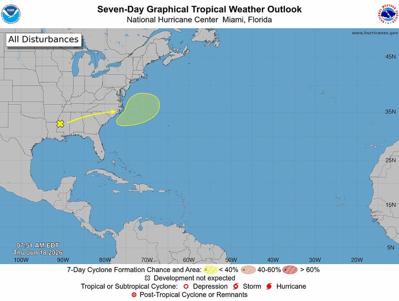
Once it reaches the warm waters of the Atlantic, there’s a small chance — as of early June 18 — it could redevelop June 19 or June 20, according to the National Hurricane Center. “Environmental conditions appear marginally conducive forsome subtropical or tropical development.”
Elsewhere in the tropics, the National Hurricane Center is watching four tropical waves. Wind shear and Saharan dust are helping prevent tropical development in the Atlantic basin.
➤ Weather alerts via text: Sign up to get updates about current storms and weather events by location
“The first waves that come off Africa are usually too far south, and there’s often too much dry air and wind shear for them to develop,” according to Alex DaSilva, AccuWeather lead hurricane expert, via email.
Countdown to end of 2026 Atlantic hurricane season
What can Florida expect from former Tropical Storm Arthur?
The western half of Florida’s Panhandle are under flood watches and warnings. Clusters of thunderstorms, some of which could become severe, are forecast to move through the western Panhandle June 18, according to the National Weather Service Mobile.
➤ WeatherTiger: Florida forecast calls for beneficial, flooding rain
The threat of a tornado can’t be ruled out.
Rainfall totals of 6 to 12 inches are most likely through June 19, with locally higher amounts of 15 inches or more possible, according to the National Weather Service Mobile.
Farther east, heavy rain and a threat of tornadoes are also expected in the central Panhandle, according to the National Weather Service Tallahassee.
What is going on with former Tropical Storm Arthur?
As of the 8 a.m. June 18 advisory, the National Hurricane Center said there is a low chance for development as Arthur’s remnants move off the U.S. coast and into the Atlantic later this week.
Showers and thunderstorms associated with a trough of low pressure (the remnants of Arthur) are located over the southeastern United States.
➤ Hurricane Center testing new cone: What’s changing this season?
Environmental conditions appear marginally conducive for some subtropical or tropical development June 19 or June 20 as the system moves northeastward at around 15 mph, and emerges offshore the east coast of the United States and into the western Atlantic Ocean.Regardless of development, heavy rainfall with the potential for widespread and life-threatening flash flooding is likely across portions of the Southeast United States during the next day or two.
Arthur could bring up to 20 inches of rain to some locations
Arthur is expected to produce rainfall totals of 5 to 10 inches, with isolated higher totals near 20 inches, through early June 19, from southern and central portions of Louisiana, Mississippi, and Alabama, along with western portions of Georgia and the Florida Panhandle, according to the National Hurricane Center.
National Hurricane Center tracking 4 tropical waves
There are four tropical waves being watched by forecasters:
What is a tropical wave?
“Tropical waves are clusters of showers and thunderstorms that act as the seedlings for many tropical storms throughout the Atlantic season,” DaSilva said.
➤ Explanation of hurricane terms we hope not to hear in Florida this year
“There are about 60 tropical waves that move across the Atlantic each year, and roughly 10 percent to 15 percent of them develop into a tropical system. That’s about one in seven.
“Tropical waves are important because they contribute to about 80 percent of all major hurricanes.”
When is hurricane season?
The Atlantic hurricane season runs from June 1 through Nov. 30.
Ninety-seven percent of tropical cyclone activity occurs during this time period, NOAA said.
➤ 2026 Atlantic hurricane season begins today. What can Florida expect?
The Atlantic basin includes the northern Atlantic Ocean, Caribbean Sea and Gulf of America, as the Gulf of Mexico is now known in the U.S. per an order from President Trump.
How many tropical storms, hurricanes are in a typical season?
The 30-year average, from 1991 to 2020, is for 14 named storms, seven hurricanes and three major hurricanes.
Could Florida be hit by a hurricane in 2026? See which counties have highest chance
What are names for 2026 Atlantic hurricane season?
Names for the 2026 Atlantic hurricane season, and how to pronounce them, are:
Florida weather radar for June 18, 2026
Weather watches and warnings issued in Florida
When is the peak of Atlantic hurricane season?
The peak of the Atlantic hurricane season is Sept. 10, with the most activity happening between mid-August and mid-October, according to the Hurricane Center.
Interactive map: See how many hurricanes, tropical storms have passed near your home
Stay informed. Get weather alerts via text
What’s next?
We will provide daily tropical weather coverage during the season to bring you the most current information you need to protect your home and family.
Cheryl McCloud is a journalist for the USA TODAY Network-Florida’s service journalism Connect team. You can get all of Florida’s best content directly in your inbox each weekday day by signing up for the free newsletter, Florida TODAY, at https://tallahassee.com/newsletters.
This article originally appeared on Tallahassee Democrat: Will Arthur re-gain tropical storm strength after reaching Atlantic?
Reporting by Cheryl McCloud, USA TODAY NETWORK – Florida / Tallahassee Democrat
USA TODAY Network via Reuters Connect
By Cheryl McCloud, USA TODAY NETWORK – Florida | USA TODAY Network