
The first tropical storm of the 2026 Atlantic hurricane season is on the cusp of forming, and it could drop as many as 7 inches of rain over the western Florida Panhandle.
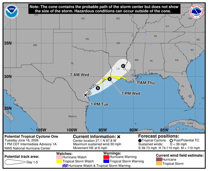
Potential Tropical Cyclone One now has a 70% chance of developing over the next 48 hours, and the National Hurricane Center expects Tropical Storm Arthur to form after it moves offshore of the Texas coast by early Wednesday morning.

Arthur is expected to be downgraded to a tropical depression by the time it reaches the Pensacola area later this week.
Potential Tropical Cyclone One timeline Tuesday
Potential Tropical Cyclone One is currently over southern Texas. The National Hurricane Center expects the system to move offshore Tuesday night.
The Pensacola area can expect to see periods of showers and thunderstorms on Wednsday, which could produce localized heavy rain and urban flooding.
The Pensacola International Airport recorded just under a quarter-inch of rain by 1 p.m. on Tuesday, noting a nearby thunderstorm and light showers.
Potential Tropical Cyclone One timeline Wednesday
The NHC forecasts the formation of Tropical Storm Arthur by early Wednesday morning, according to its 1 p.m. advisory. It is expected to move northeast parallel to the Texas coastline for about a day before moving inland late Wednesday.
Showers and storms will continue to hit the Pensacola area on Wednesday as Arthur approaches, but marine conditions are expected to deteriorate, according to the NHC.
Surf and rip current danger is expected to increase, and southerly winds are forecast to strengthen.
Potential Tropical Cyclone One timeline Thursday
Arthur is expected to be downgraded to a tropical depression by Thursday. It should reach Mississippi by Thursday morning, according to the NHC.
The biggest threat of severe storms will fall on Thursday. Storms could become strong to marginally severe, producing damaging wind gusts and heavy downpours. The NHC also says that there is a low risk of isolated tornadoes spinning up on Thursday.
Weekend forecast in Pensacola
The NWS expects the area to receive between 4 and 7 inches of rain through Friday. Additional rainfall amounts between 1 and 2 inches are expected to fall over the weekend.
Saturday brings the chance of showers and thunderstorms before 1 p.m., and a 20% chance of showers and thunderstorms Saturday night.
Sunday has a 50% chance of showers and thunderstorms throughout the day, but should be just partly cloudy later that evening.
This article originally appeared on Pensacola News Journal: When will Potential Tropical Cyclone One reach Pensacola?
Reporting by Brandon Girod, Pensacola News Journal / Pensacola News Journal
USA TODAY Network via Reuters Connect
By Brandon Girod, Pensacola News Journal | USA TODAY Network