
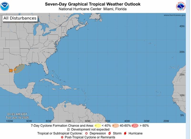
An ambitious knot of showers and thunderstorms is working to earn the name Arthur, the first tropical cyclone of 2026, but it is expected to be short-lived and sloppy if it gains the title.
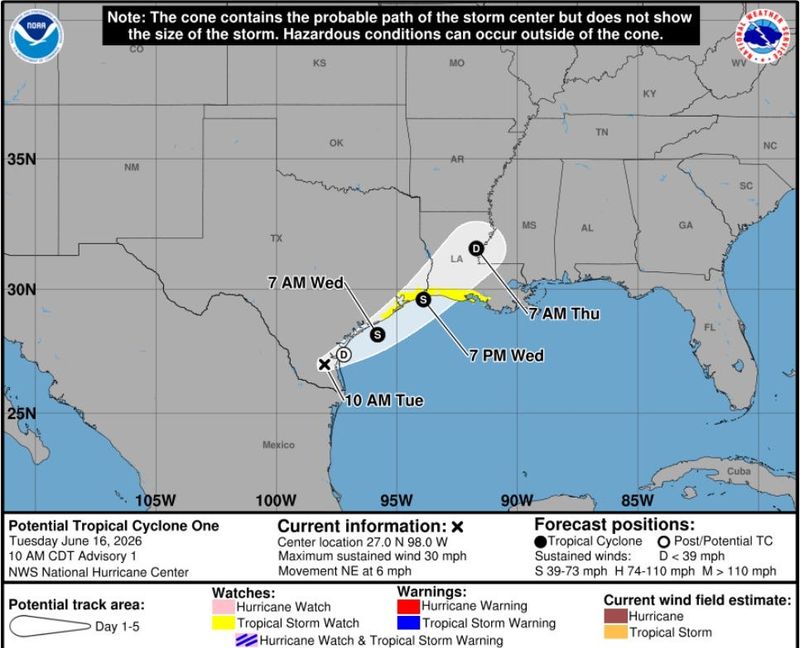
The system, which was dubbed Invest 90L on Monday June 15 and upgraded to Potential Tropical Cyclone One on Tuesday, is over southern Texas and is forecast to emerge over the northwestern Gulf today.

The Gulf is sufficiently warm to support cyclone spin up, and other conditions, including wind shear, are “marginally” welcoming for the formation of a tropical storm, according to the National Hurricane Center in a an advisory early Tuesday June 16.
NHC meteorologists name a “potential tropical cyclone” or PTC when they want to issue watches and warnings for a system that technically hasn’t formed yet but is expected to impact land. A tropical cyclone is partly defined as having a closed center of circulation, which PTC One didn’t have as of early Tuesday.
The NHC issued a tropical storm watch at 11 a.m. Tuesday for areas from Sargent, Texas to Morgan City, Louisiana. In this case, the watch means tropical storm conditions are possible within 24 to 36 hours.
Regardless of whether the would-be Arthur gains purchase, areas of southern and eastern Texas and portions of Louisiana and Mississippi are expected to get spats of intense rainfall for several days which may mean “widespread, life-threatening flash, urban and river flooding.”
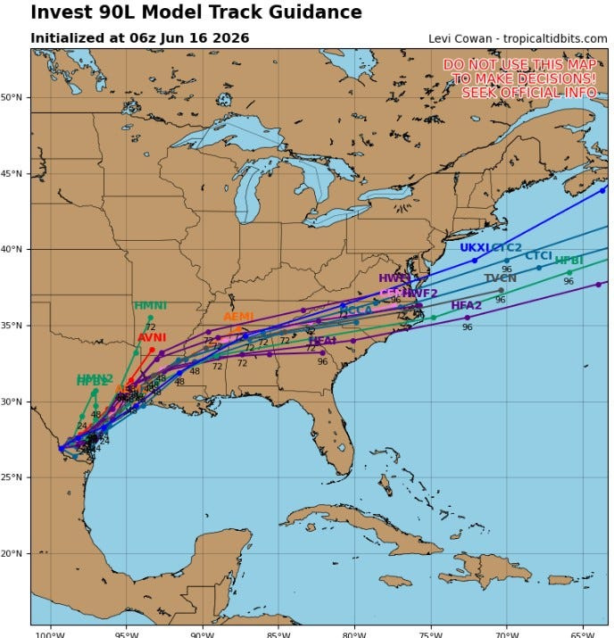
Weather models show the system tracking over the Gulf late Tuesday with winds increasing to tropical storm-force on Wednesday, June 17. It is then expected to move inland and cutt quickly east with an exit into the Atlantic Ocean over the Carolinas.
It could take a swipe at Florida’s western Panhandle with downpours and elevated chances of flooding through the week. The Weather Prediction Center is forecasting “marginal” to “slight” chances of excessive rainfall into the weekend.
As much as 7 inches of rain is possible near the border of Alabama and Florida through Sunday, June 21.
National Weather Service forecasters based in Mobile, Alabama, which forecasts for Pensacola, warned of a “cloudy and rainy week” ahead as a massive dip in the jet stream extends from the Rockies to the East Coast.
What’s the path of the tropical system in Texas?
The jet stream droop is helping complicate the tropical forecast, which is already a jumble with moisture from the Pacific’s Tropical Storm Cristina mixing with a tropical wave that stumbled through the Caribbean earlier this season, according to AccuWeather lead hurricane forecaster Alex DaSilva.
“By the middle of the week, the plume of moisture with or without an organized area of low pressure is forecast to merge with a cold front moving in from the north,” DaSilva said. “This setup will lead to widespread heavy rain across the Gulf Coast states.”
While tropical cyclones are known to form along frontal boundaries early in the hurricane season as spring turns to summer, DaSilva said he has never seen a genesis such as what’s happening with 90L.
The energy and moisture from the Pacific’s Cristina and the tropical wave came together in the Bay of Campeche, he said. The jet stream is helping pick up the combined forces and send them east with the help of high pressure that stretches deep into the Gulf.
“It’s very unusual,” DaSilva said. “But at the end of the day, the rain is going to be the biggest impact.”
Some areas of southeast Texas have already been drenched by the lingering frontal boundary with rainfall rates exceeding 5 inches per hour.
Texas Gov. Greg Abbott issued a disaster declaration for 101 counties on June 15 as severe storms battered the state and in anticipation of tropical development.
“They do need the rain, but they don’t want to see it all at one time,” DaSilva said about Texas.
Michael Lowry, a hurricane specialist at WPLG TV in Miami, emphasized that it doesn’t take a system to develop tropical cyclone qualities to dump heavy rainfall.
Is Florida still under drought conditions?
Florida continues to struggle with 31% of the state in extreme to exceptional drought, which are the highest two categories on the U.S. Drought Monitor scale. But the dryness has lessened in the Panhandle west of Panama City where moderate to severe drought persists.
Escambia County, which could get hit hardest by this week’s rainfall, is considered only “abnormally dry” and free of drought.
“We’ll keep an eye on the trends for brief tropical development by mid-week, but either way the upshot will be a wide stretch of real estate impacted by heavy rains and the risk of numerous flash floods through the end of the week,” Lowry wrote in his Eye on the Tropics column.
The potential for Arthur to form comes a week after Colorado State University reduced its forecast for hurricane activity this storm season. A new prediction calls for 11 named storms, five hurricanes and two major hurricanes of Category 3 or higher.
How many storms are in an average hurricane season?
An average hurricane season has 14 named storms, seven hurricanes and three major hurricanes.
An initial CSU forecast released in April called for 13 named storms, six hurricanes and two major hurricanes.
Phil Klotzbach, CSU hurricane researcher and lead author of the forecast, said years with similar atmospheric set ups to this season all had below average hurricane activity.
“The relative lack of activity in our analog seasons increases our confidence in a below normal 2026 Atlantic hurricane season,” Klotzbach said in a statement.
What factor does El Niño play during hurricane season for Florida?
Hurricane season forecasts are largely based on the phase of the El Niño Southern Oscillation, which includes the cyclone shredding El Niño and storm friendly La Niña.
On June 11, the Climate Prediction Center declared that El Niño had developed based on temperatures in the equatorial Pacific Ocean and is expected to intensify into the winter months.
There is a 63% chance of a “very strong” El Niño beginning in November that would rank among the “largest El Niño events in the historical record dating back to 1950.”
The strength of El Niño correlates with its impact on hurricane season, with a stronger pattern creating more hurricane-shredding wind shear. An exception to that happened in 2023 when superheated ocean temperatures overcame wind shear, allowing an impressive 20 named storms to form.
Still, only Idalia and Tropical Storm Harold made U.S. landfalls that year with many storms curving out to sea after forming in the eastern reaches of the main development region — the runway between Africa and the Caribbean.
“The current El Niño is as textbook as it gets and is considered a canonical or classical El Niño, with major impacts expected globally,” Lowry said.
Kimberly Miller is a journalist for the USA TODAY NETWORK FLORIDA. She covers weather, the environment and critters as the Embracing Florida reporter. If you have news tips, please send them to kmiller@pbpost.com. You can get all of Florida’s best content directly in your inbox each weekday by signing up for the free newsletter, Florida TODAY, at palmbeachpost.com/newsletters.
This article originally appeared on Pensacola News Journal: Expected Tropical Storm Arthur could hit Pensacola, bring 7 inches of rain
Reporting by Kimberly Miller, USA TODAY NETWORK – Florida / Pensacola News Journal
USA TODAY Network via Reuters Connect
By Kimberly Miller, USA TODAY NETWORK – Florida | USA TODAY Network