
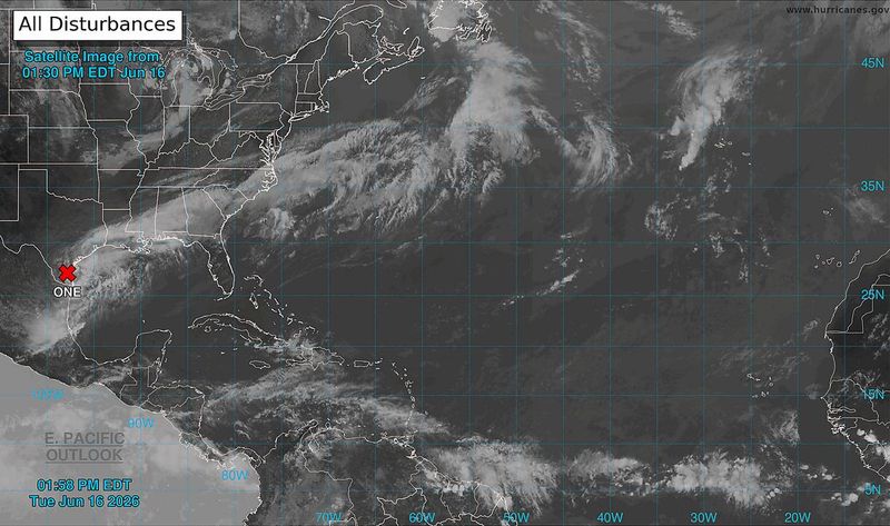
The National Hurricane Center is keeping a close eye on what it has named Potential Tropical Cyclone One, and Floridians living in the Panhandle should be, too.
The disturbance currently has a 70% chance of forming over the next 48 hours. The NHC says it’s likely that a short-lived tropical storm will form late Tuesday or Wednesday.

Arthur is the first named storm of the Atlantic hurricane season.
Forecasters aren’t worried about the storm’s development potential, however. They warn that it will bring widespread, life-threatening flooding and gusty winds over portions of the northwestern Gulf Coast regardless of how it develops.
Here is what Florida Panhandle residents should know about the potential Tropical Storm Arthur and its impacts.
Latest updates on Potential Tropical Cyclone One (Arthur)
Potential Tropical Cyclone One is crawling northeast across the southern tip of Texas, as of 1 p.m.
The NHC expects the disturbance to move offshore Tuesday night or early Wednesday morning, where it will move parallel to the upper Texas coast.
From there, it will move back inland in extreme eastern Texas or southwestern Louisiana late Wednesday or early Thursday, according to the NHC.
Potential Tropical Cyclone One (Arthur) maps and visuals
Potential Tropical Cyclone One (Arthur) impacts
The NHC expects Arthur to be a heavy rainmaker, with rainfall totals estimated between 4 and 8 inches, and isolated higher totals around 12 inches.
Arthur is expected to hit Texas, Louisiana and Mississippi the hardest, with impacts stretching into Alabama and the western Florida Panhandle.
Tropical storm conditions will be possible within the watch area starting early Wednesday.
Storm surge is expected to rise between 2 and 4 feet at the time of high tide between Port Bolivar, Texas, to Morgan City, Louisiana.
Potential Tropical Cyclone One (Arthur) Florida Panhandle impacts
Tropical Storm Arthur, should it form, isn’t expected to reach our area until Thursday and Friday, but early lines of storms ahead of the tropical system were already forecast to cause heavy downpours and potentially bring severe storms and flash flooding.
The Pensacola area had a marginal risk of severe storms on Monday, but avoided most of the rain. The Pensacola International Airport had measured about a quarter of an inch of rain overnight on Monday and into early Tuesday morning.
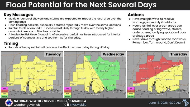
The National Weather Service elevated the risk of severe storms to “slight” on Tuesday and extended it through at least Thursday. It estimates that as much as 3 to 6 inches of rain will fall through Friday, with locally higher amounts potentially exceeding 8 inches.
Potential Tropical Cyclone One (Arthur) spaghetti models
Special note about spaghetti models: Illustrations include an array of forecast tools and models, and not all are created equal. The Hurricane Center uses only the top four or five highest performing models to help make its forecasts.
Pensacola hourly forecast
Severe weather maps
Severe weather radar Pensacola, Florida
Severe weather alerts for Pensacola, Florida
This article originally appeared on Pensacola News Journal: Potential Tropical Cyclone Arthur to drench Florida Panhandle
Reporting by Brandon Girod, Pensacola News Journal / Pensacola News Journal
USA TODAY Network via Reuters Connect
By Brandon Girod, Pensacola News Journal | USA TODAY Network