PANAMA CITY – A tropical system with low chances of development still could affect local weather conditions.
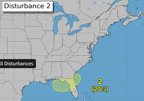
It’s hurricane season again, meaning many in Bay County are closely watching the blobs charted by the National Hurricane Center. The NHC has drawn one up, primarily encompassing the Gulf offshore of the Florida Panhandle and Big Bend.

It is an area of low pressure that could form over our part of Florida, but chances of it developing into an actual tropical cyclone are fairly low, just 20% between July 17 and 24.
While residents may not have to rush to Walmart or Publix to pick up bottled water, this system still could still have some significant weather effects on Bay and the surrounding counties.
The National Weather Service’s Tallahassee office says heavy rain and flash flooding are possible in some areas over the weekend of July 17 and into the week of July 20.
“The (weather) pattern then gets more active for our area, mainly due to whatever will attempt to form in the northeastern Gulf over the weekend,” an NWS meteorologist writes in the area forecast discussion. “The forecast beyond that largely hinges on what happens in the northeastern Gulf over the weekend into next week.”
While NWS Tallahassee is currently closely monitoring for vorticity (air rotation), all it could say for now is to expect scattered to numerous showers and thunderstorms. The office is expecting 1 to 3 inches of rainfall in the region, with locally heavy amounts of 5 inches possible between the weekend of July 17 and early into the week of July 20.
This prompted the Weather Prediction Center to forecast a marginal (1 out of 4) risk of excessive rainfall for our area.
Forecasters are also warning that heat advisories may be necessary, as dangerous temperatures are anticipated after the weekend. Heat index values in Panama City were 105 on July 17.
Above-normal temperatures and below-normal precipitation are predicted over the next month, per the Climate Prediction Center.
As far as potential hurricanes go, the NHC is tracking one other system, which has a 10% chance of cyclone formation over the next seven days, hanging out off the west coast of Africa. No U.S. impacts are anticipated at this time.
In some good news, the rainy season has downgraded Bay County’s drought status from extreme (4 out of 5) to abnormally dry (1 out of 5). Previous reporting from the News Herald showed NWS forecasters are hoping for enough precipitation to significantly recharge ground and surface waters ahead of the dry season.
This article originally appeared on The News Herald: NHC tracks Gulf system that could impact Bay County
Reporting by Dylan Gentile, Panama City News Herald / The News Herald
USA TODAY Network via Reuters Connect
By Dylan Gentile, Panama City News Herald | USA TODAY Network