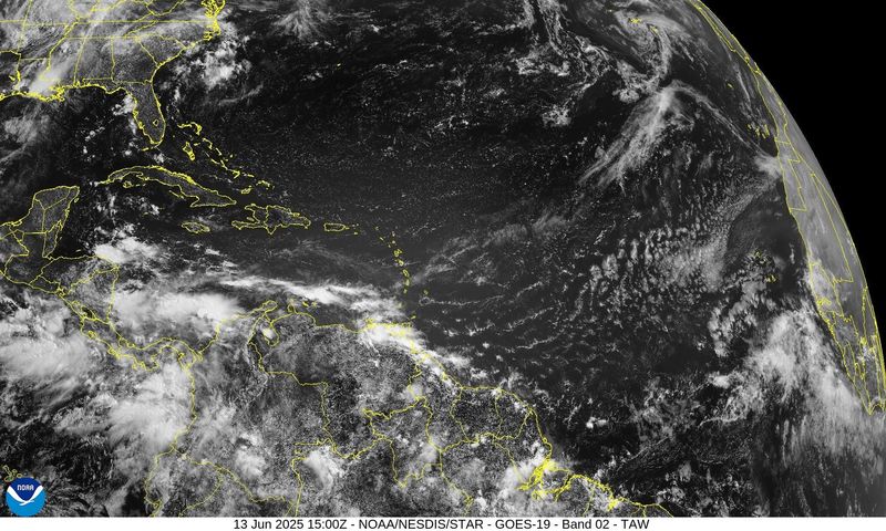
The National Hurricane Center is tracking three tropical storms across the Caribbean and the Atlantic, according to Monday’s tropical outlook.
The latest tropical wave is just starting to move west from the African coast, while the others are tracking across the central Atlantic and the western Caribbean.

No tropical development is expected over the next seven days despite a continued stream of tropical waves spilling across the Atlantic, keeping up with the current trend of a relatively tame Atlantic hurricane season.
While the vast majority of tropical storms and hurricanes originate from the wave, it’s relatively rare to see one organize and strengthen into a named storm this early in the season. Since 1991, June has usually only averaged one named storm.
The start of the 2025 Atlantic hurricane season may appear to be struggling to get going, but historical data shows that’s not quite the case, and forecasters warn not to let the appearance beget complacency.
Where are the tropical waves now
The NHC is tracking three tropical waves as they move across the Atlantic, central Atlantic and the Caribbean Sea. Here’s where they’re at now, according to the Monday morning tropical outlook.
What are tropical waves and why do meteorologists track them?
Tropical waves, sometimes referred to as easterly waves, are an elongated area of clouds and thunderstorms that move across the Atlantic basin, according to the National Weather Service.
In the Atlantic, they tend to form off the western African coast, though their roots are often traced to the Indian Monsoon season, which runs from June through September.
When meteorologists say they are tracking tropical waves, they mean they are monitoring big ripples or waves in the atmosphere, usually over warm ocean water. These waves can produce clouds, rain and storms.
Tropical waves are important to track because 85% of all tropical storm development can be traced back to them, according to AccuWeather.
What creates tropical waves?
In the Atlantic, tropical waves tend to form off the coast of Africa, where winds from the north and south of the equator converge and create a rising motion.
With enough moisture, instability and the right positioning relevant to the equator, the convergence can come together to create a tropical wave, kicking off thunderstorm activity.
The disturbances don’t always build up to become tropical cyclones, however. Tropical waves must contend with wind shear and Saharan dust as they track westward, both of which could cause any budding storm to fizzle out before reaching the Caribbean Sea’s warm waters and moist air.
When does the Atlantic usually see its first hurricane?
Tropical development in the Pacific basin ramps up a bit earlier than the Atlantic, which is why it starts on May 15 instead of June 1.
NOAA says that June tends to see an average of 5.5 named storms between the two basins, with the Atlantic seeing about one. Storms tend to form later in June, too, around June 20.
So, when can we expect to see the first hurricane? Not until mid-August, according to NOAA. The first hurricane of the Atlantic hurricane season forms around Aug. 11, according to historical data between 1991-2020. The first major hurricane tends to pop up around Sept. 1.
What will hurricane season bring in July?
Unlike the Pacific, the Atlantic hurricane season’s window for tropical activity is heavily condensed between August and October, which means July is still pretty early.
Since 1851, July has accounted for only 7% of the Atlantic’s tropical storms, according to NOAA, which totals around 146 storms. Roughly 43.8% of those storms have intensified into a hurricane. That puts the odds of a hurricane forming in July at about once every three years.
In other words, you don’t need to worry about explosive tropical activity in July, but you should still remain watchful.
Historical data showing the point of origin for tropical development in June is focused around the Gulf and the Caribbean, with very little activity in the Atlantic. That will start to change in July as formation areas spread eastward.
National Hurricane Center map: What are forecasters watching now?
How long does the Atlantic hurricane season last?
The U.S. experiences two hurricane seasons: The Atlantic and the Pacific. Floridians are on the receiving end of the Atlantic hurricane season, which runs annually from June 1 to Nov. 30. The Pacific hurricane season runs from May 15 to Nov. 30.
Is there a hurricane coming toward Florida?
The NHC does not expect to see any tropical activity over the next seven days.
Forecasters predict 13-19 tropical storms during 2025 Atlantic hurricane season
All of the major forecasters have released their outlooks for the 2025 Atlantic hurricane season, which lean toward another active one. Here’s a brief look at their forecasts:
CSU hurricane season predictions
NOAA hurricane season predictions
AccuWeather hurricane season predictions
This article originally appeared on Pensacola News Journal: NHC continues tracking 3 tropical waves across the Atlantic. When will we see first storm?
Reporting by Brandon Girod, Pensacola News Journal / Pensacola News Journal
USA TODAY Network via Reuters Connect