A day after surging to Category 4 status and then hitting Mexico on June 19 as a powerful Category 3 hurricane with maximum sustained winds of 125 mph, Erick has dropped down to a low-pressure area in the Pacific, according to the National Hurricane Center.
Erick made landfall between Acapulco and the resort town Puerto Escondido early Thursday morning, the Associated Press reported, leaving damaged roads, localized flooding, widespread power outages and at least one person dead, a 1-year-old child whose mother had attempted to cross a swollen river.

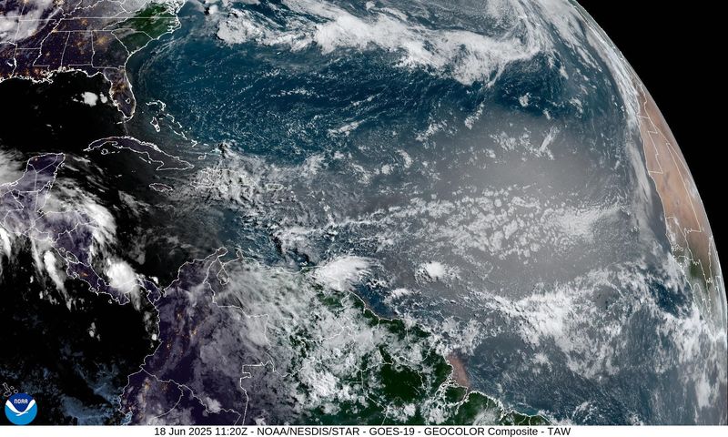
In the Atlantic basin, the early days of the 2025 hurricane season remain quiet. The National Hurricane Center is monitoring four tropical waves, including one in the eastern Caribbean.
The first named storm in the Atlantic basin will be Andrea.
➤ Track all active storms
➤ Weather alerts via text: Sign up to get updates about current storms and weather events by location
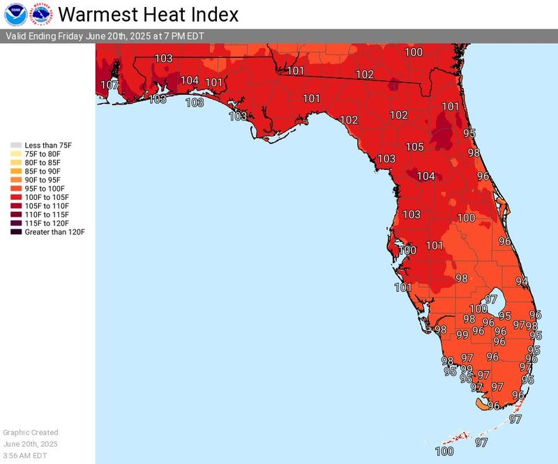
Temperatures are expected to remain hot in Florida through the weekend, with the heat index reaching as high as 110 in some locations.
Here’s the latest advisory from the National Hurricane Center as of 7 a.m. June 20.
What is ‘rapid intensitification’?
Before striking Mexico, Erick doubled in strength in less than a day.
Last year there were 34 incidents of rapid intensification — when a storm gains at least 35 mph in 24 hours — including the two storms that ravaged Florida. Hurricane Helene spun up from a tropical storm to a Category 4 monster in two days, and Hurricane Milton roared into a Category 5 from a tropical storm within just 24 hours.
That’s nearly twice as many as the average of the past 10 years, the NHC said. Such rapid changes make forecasting challenging and can leave residents unprepared.
“Rapid intensification occurs when a tropical storm or hurricane encounters an extremely conducive environment,” Colorado State University meteorologist Phil Klotzbach said in 2020. “Typically, this environment consists of very warm water, low vertical wind shear and high levels of mid-level moisture.”
What tropical waves, disturbances are in Atlantic basin now?
The National Hurricane Center is monitoring four tropical waves in the Atlantic basin.
“The average first named storm in the Atlantic is June 20, but development over the central and eastern basin looks unfavorable through June at this time,” said Alex DaSilva, AccuWeather lead hurricane expert.
Is more Saharan dust heading toward Florida?
“There is some dust moving through the Caribbean right now but most of it will stay south and west of Florida. Some will move into Texas and Louisiana late this week,” DaSilva said.
The next plume of dust that could impact South Florida may arrive around June 27 and could last a few days, DaSilva said via email.
“The dust set to arrive in Florida in around 10 days could be comparable to the dust that went through Florida recently, however since it is still 10 days away and still over Africa, the dust concentration is still subject to change as it moves across the Atlantic.”
Why are the tropics so quiet in the Atlantic?
“Strong wind shear and an abundance of Saharan dust is helping to protect Florida,” DaSilva said.
There are “no concerns in the Atlantic for at least the next seven days. There is too much dry air and the wind shear is too high,” DaSilva said. “If anything develops in June it would likely be in the Bay of Campeche or far western Caribbean, where the shear is a little lower.”
“The average first named storm in the Atlantic is June 20 and the average first hurricane is Aug. 11. It is not really that unusual for the start of the season to be quiet. Water temperatures and ocean heat content remain very high in the Gulf.
“I think once we get more into the heart of the season, things could get very active. Expect a second-half loaded season.
Dry air, including associated Saharan dust, along with wind shear, both prevent tropical systems from developing or strengthening, essentially cutting off the fuel storms need.
Florida weather radar for June 12, 2025
Florida weather forecast for June 20, 2025
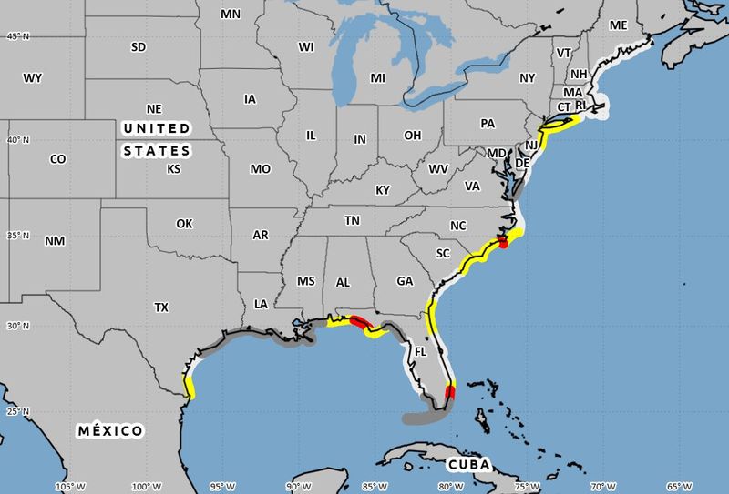
National Hurricane Center’s new rip current risk map shows dangerous areas in Florida, US
Among the changes the National Hurricane Center announced for the 2025 hurricane season was the addition of a rip current risk map.
➤ National Hurricane Center lays out changes coming for 2025 season. See what to expect
This new addition provided by the Hurricane Center will be provided for the current day, the next day, and as a composite showing the highest risk over both days for areas along the East and Gulf coasts of the United States, Puerto Rico and the U.S. Virgin Islands, and the coast of southern California.
➤ Florida ranks in top 5 states where swimming is most dangerous. How to avoid summer tragedy
Weather watches and warnings issued in Florida
When is the Atlantic hurricane season?
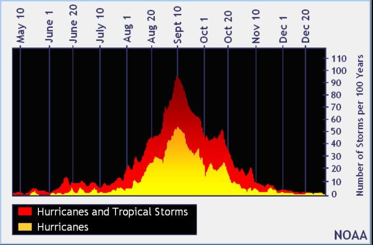
The Atlantic hurricane season runs from June 1 through Nov. 30.
Ninety-seven percent of tropical cyclone activity occurs during this time period, NOAA said.
The Atlantic basin includes the northern Atlantic Ocean, Caribbean Sea and Gulf of America, as the Gulf of Mexico is now known in the U.S. per an order from President Trump. NOAA and the National Hurricane Center are now using Gulf of America on its maps and in its advisories.
When does hurricane season start? When is the peak?
The peak of the season is Sept. 10, with the most activity happening between mid-August and mid-October, according to the Hurricane Center. Hurricane season starts June 1 in the Atlantic basin.
National Hurricane Center map: See what forecasters watching now
Systems currently being monitored by the National Hurricane Center include:
Why does NHC say ‘tropical cyclone’ on its maps instead of hurricane or tropical storm?
Tropical cyclone is the generic term used by the National Weather Service, NOAA and the National Hurricane Center for any tropical system, even if it’s in the tropical Atlantic basin.
To be more precise, a tropical cyclone is a “rotating, organized system of clouds and thunderstorms that originates over tropical or subtropical waters and has closed, low-level circulation,” NOAA sadi.
Once maximum sustained winds reach 74 mph, what it is called is determined by where it originated:
Interactive map: Hurricanes, tropical storms that have passed near your city
Stay informed. Get weather alerts via text
What’s next?
We will update our tropical weather coverage daily.
Download your local site’s app to ensure you’re always connected to the news. And look for our special subscription offers here.
This story was updated to add new information.
This article originally appeared on The Daytona Beach News-Journal: National Hurricane Center tracking 4 tropical waves. Dangerous heat expected in Florida
Reporting by C. A. Bridges and Cheryl McCloud, USA TODAY NETWORK – Florida / The Daytona Beach News-Journal
USA TODAY Network via Reuters Connect