Tropical activity remains quiet in the Atlantic basin, although there have already been three named storms in the eastern Pacific.
The National Hurricane Center is watching three tropical waves, including one approaching the Caribbean.

➤ Track all active storms
➤ Weather alerts via text: Sign up to get updates about current storms and weather events by location
Expect Tuesday, June 10, to be warm across Florida, with showers and thunderstorms in several locations, especially North Florida, according to the National Weather Service.
Elsewhere, the forecast calls for heat index values into triple digits, with some locations possibly seeing the feels-like temp as high as 105.
Forecasters also warned about extreme UV index along Florida’s east coast.
Another large plume of dust moving across the Atlantic could reach Florida around June 13, according to AccuWeather. Dust, along with wind shear, help suppress tropical development.
Here’s the latest advisory from the National Hurricane Center as of 8 a.m., June 10:
What tropical waves, disturbances are in Atlantic basin now?
The National Hurricane Center is monitoring three tropical waves in the Atlantic:
“The average first named storm in the Atlantic is June 20, but development over the central and eastern basin looks unfavorable through June at this time,” said AccuWeather Lead Hurricane Forecaster Alex DaSilva.
Now is the time to prepare for a hurricane, before a storm is approaching.
Tropical activity busy in eastern Pacific
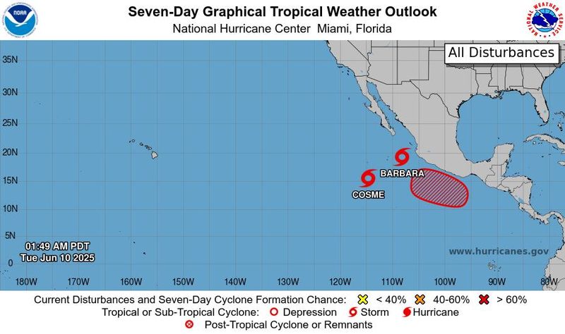
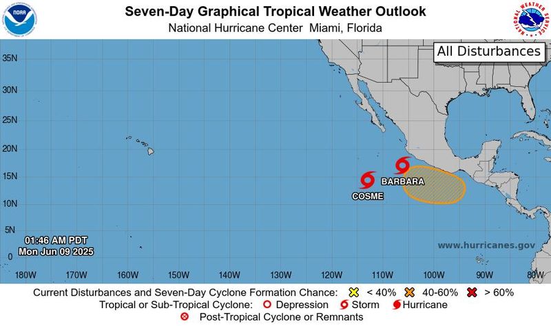
After becoming the first hurricane of the 2025 season in the eastern Pacific on June 9, Barbara quickly weakened back into a tropical storm.
➤ Storm tracker: NHC tracks Tropical Storms Barbara and Cosme
By 2 a.m. June 10, Tropical Storm Barbara continues to weaken and is expected to dissipate by June 11. Swells generated by Barbara will affect portions of the coast of southwestern and west-central Mexico, as well as the southernmost portions of Baja California through June 10, according to the National Hurricane Center.
Tropical Storm Cosme is “holding steady,” and little change in strength is expected over the next 12 hours. Weakening is expected this morning (June 10).
Neither Barbara nor Cosme are expected to directly impact land, according to AccuWeather.
Southeast of the two tropical storms is an area of low pressure expected to strengthen into a tropical depression later this week or over the weekend. Chances for development is 70%.
What are the chances of a tropical storm, hurricane forming in June? Is anything out there now?
Historically, tropical cyclones form close to the U.S. in June, with the most common locations being the northwestern Caribbean and the eastern Gulf, according to Dr. Ryan Truchelut, chief meteorologist with WeatherTiger. Truchelut is a Florida meteorologist who works with the USA TODAY Network.
“None of the reputable forecast models are showing a realistic chance of anything tropical forming on the Atlantic side of Central America through mid-month.”
➤ WeatherTiger: False alarms, beneficial rain and a dusty start to Florida storm season
The exception is the GFS model, which is predicting a Caribbean tropical storm will spin up in 10 to 12 days, then move generally northward, Truchelut said.
“The GFS has a persistent and well-known bias for incorrectly predicting development in the Caribbean at this specific time of year,” Truchelut said. “All told, while something could eventually spin up in two or three weeks, the GFS’ frequent false alarms should be disregarded.”
What is a ghost hurricane?
A “ghost hurricane” is a term used to describe a tropical storm or hurricane that appears in a forecast model but which doesn’t happen in reality, according to CNN.
Florida weather radar for June 10, 2025
Florida weather forecast for June 10, 2025
What does an extreme heat index mean? How to check based on address
An extreme heat index, which is anything over 11, means protection against sun damage is needed, according to the U.S. Department of Environmental Protection.
“A UV Index reading of 11 or higher means extreme risk of harm from unprotected sun exposure,” the National Weather Service said.
“Try to avoid sun exposure during midday hours, from 10 a.m. to 4 p.m. Apply sunscreen with an SPF of at least 30 liberally every two hours. Take all precautions. Unprotected skin can burn in minutes.”
➤ Enter your address to see UV index where you live
“Beachgoers should know that white sand and other bright surfaces reflect UV and can double UV exposure.”
Weather watches and warnings issued in Florida
When is the Atlantic hurricane season?
The Atlantic hurricane season runs from June 1 through Nov. 30.
Ninety-seven percent of tropical cyclone activity occurs during this time period, NOAA said.
The Atlantic basin includes the northern Atlantic Ocean, Caribbean Sea and Gulf of America, as the Gulf of Mexico is now known in the U.S. per an order from President Trump. NOAA and the National Hurricane Center are now using Gulf of America on its maps and in its advisories.
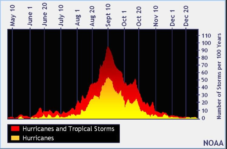
When is the peak of hurricane season?
The peak of the season is Sept. 10, with the most activity happening between mid-August and mid-October, according to the Hurricane Center.
National Hurricane Center map: See what forecasters watching now
Systems currently being monitored by the National Hurricane Center include:
Why does NHC say ‘tropical cyclone’ on its maps instead of hurricane or tropical storm?
Tropical cyclone is the generic term used by the National Weather Service, NOAA and the National Hurricane Center for any tropical system, even if it’s in the tropical Atlantic basin.
To be more precise, a tropical cyclone is a “rotating, organized system of clouds and thunderstorms that originates over tropical or subtropical waters and has closed, low-level circulation,” NOAA said.
Once maximum sustained winds reach 74 mph, what it is called is determined by where it originated:
Interactive map: Hurricanes, tropical storms that have passed near your city
Stay informed. Get weather alerts via text
What’s next?
We will update our tropical weather coverage daily.
Download your local site’s app to ensure you’re always connected to the news. And look for our special subscription offers here.
This article originally appeared on Treasure Coast Newspapers: National Hurricane Center keeping eye on 3 tropical waves. See latest on Saharan dust, Florida heat
Reporting by Cheryl McCloud, USA TODAY NETWORK – Florida / Treasure Coast Newspapers
USA TODAY Network via Reuters Connect