In a rush? Get an abbreviated, text view of what’s happening in the tropics.
As former Tropical Storm Fernand finally begins to dissipate, a new tropical wave is expected to emerge soon off the coast of Africa. It’s already been added to the National Hurricane Center’s tropical outlook map as something to watch.

The National Hurricane Center issued its final advisory on Fernand early Thursday, Aug. 28, as Fernand became a post-tropical cyclone.
➤ Track all active storms
➤ Weather alerts via text: Sign up to get updates about current storms and weather events by location
The tropical wave is expected to emerge off the west coast of Africa over the Labor Day weekend. Environmental conditions appear favorable for development as it moves quickly across the Atlantic.
The next named storms of the season will be Gabrielle and Humberto.
Here’s the latest advisory from the National Hurricane Center as of 2 p.m. Aug. 28:
See projected path for Post-Tropical Cyclone Fernand
Special note on the NHC cone: The forecast track shows the most likely path of the center of the storm. It does not illustrate the full width of the storm or its impacts, and the center of the storm is likely to travel outside the cone up to 33% of the time.
➤ Track Post-Tropical Cyclone Fernand
Post-Tropical Cyclone Fernand has become a post-tropical cyclone as it moves east-northeast in the northern Atlantic.
Maximum sustained winds have decreased to near 45 mph, with higher gusts. Tropical-storm-force winds extend outward up to 80 miles.
There are no hazards to land associated with Fernand.
What tropical waves, disturbances are in Atlantic basin now?
The National Hurricane Center has issued its final advisory on what’s now Post-Tropical Cyclone Fernand. A tropical wave with a potential for development is expected to emerge off the coast of Africa over the weekend.
Other tropical waves being monitored by the National Hurricane Center include:
Could Florida face any tropical risks as we enter Labor Day weekend?
Conditions close to the United States are more favorable for tropical depression formation due to the Gulf Stream current and the warm Gulf waters, according to AccuWeather.
“We expect an unusually strong dip in the jet stream to push into the Southeast states over the holiday weekend, which could help spin up homegrown tropical development,” said AccuWeather Lead Hurricane Expert Alex DaSilva.
➤ Is there a cold front coming to Florida for Labor Day weekend? See forecast, check water quality
The risk for tropical development is low, but “regardless of development, a wet pattern looks to be in place for the holiday weekend across portions of the Southeast,” DaSilva said via email Aug. 26.
“Sea surface temperatures in the Gulf are extremely warm,” DaSilva said. “This is of great concern, as the ‘untapped’ waters of the Gulf could allow any budding tropical entity to rapidly intensify.”
Colorado State University predicting ‘quieter period’ in Atlantic basin through Sept. 2
“Following Hurricane Erin becoming post-tropical … we anticipate a quieter period for Atlantic hurricane activity,” Colorado State University said in its two-week forecast for Aug. 20-Sept. 2.
Historically, “the primary threat formation area for major hurricanes in late August is in the eastern and central tropical Atlantic,” CSU said.
“We are approaching the climatological peak of the season, and there is certainly potential for other TCs — tropical cyclones — to form, especially given that the large-scale environment doesn’t look especially harsh.”
What should you do now to prepare for hurricane season?
Officials regularly encourage Florida residents to prepare for storms before a hurricane is approaching, while shelves are fully stocked and you aren’t battling crowds all rushing to the store at the same time.
➤ Don’t have a hurricane supply kit? From the basics to the extras, here’s what you need
“It only takes one storm to make it an impactful year for your community,” the National Hurricane Center Miami posted on X. “Hurricane season is a marathon, not a sprint.”
On Aug. 1, specific hurricane supplies became permanently tax-free in Florida, ranging from batteries to generators.
➤ See list of emergency supplies you can now buy tax free
Florida weather radar for Aug. 28, 2025
Weather watches and warnings issued in Florida
When is the Atlantic hurricane season?
The Atlantic hurricane season runs from June 1 through Nov. 30.
Ninety-seven percent of tropical cyclone activity occurs during this time period, NOAA said.
The Atlantic basin includes the northern Atlantic Ocean, Caribbean Sea and Gulf of America, as the Gulf of Mexico is now known in the U.S. per an order from President Trump. NOAA and the National Hurricane Center are now using Gulf of America on its maps and in its advisories.
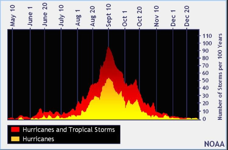
When is the peak of hurricane season?
The peak of the season is Sept. 10, with the most activity happening between mid-August and mid-October, according to the Hurricane Center.
Hurricane names for 2025 season
Here are the names for the 2025 Atlantic hurricane season, along with how to pronounce them.
National Hurricane Center map: See what forecasters are watching now
Systems currently being monitored by the National Hurricane Center include:
Interactive map: Hurricanes, tropical storms that have passed near your city
Stay informed. Get weather alerts via text
What’s next?
We will update our tropical weather coverage daily.
Download your local site’s app to ensure you’re always connected to the news. And look for our special subscription offers here.
This story has been updated to include new information.
This article originally appeared on Fort Myers News-Press: National Hurricane Center bids farewell to Fernand as new tropical wave appears. What to know
Reporting by Cheryl McCloud, USA TODAY NETWORK – Florida / Fort Myers News-Press
USA TODAY Network via Reuters Connect