It’s a girl.
Last week, the National Weather Service announced the official return of La Niña conditions, defined as widespread cooler-than-average sea surface temperatures in the central and eastern Equatorial Pacific. And while there is no threat of a U.S. landfall over the upcoming 7 days, that La Niña may give a boost to a Caribbean tropical disturbance, designated 98L, worth monitoring late next week and beyond.

The implications of a La Niña for global weather patterns over the next six months are manifold, including raising the odds of a colder, snowier winter in the northwest U.S. and a drier, milder winter in the southern tier. Like most gender reveals, the re-emergence of La Niña also brings a good chance of destructive fires. Historically, some of Florida’s worst drought and wildfire seasons, such as 2017, have followed La Niña winters.
If it seems to you like that type of outlook has been common recently, you’re right.
For the first time in at least a century, the 2025-26 La Niña is the fifth such event in six years, a major contributing factor to the hurricane seasons of the 2020s feeling endless. La Niña usually enhances late-season tropical activity in the Gulf and Caribbean by diminishing upper-level wind shear; as such, 2020, 2022, and 2024 all had threatening or impactful tropical systems in November, when the season typically is winding down.
Not all Niñas are equal, and the 2025 iteration is both weaker and slower to develop than some other recent events. This is not unusual for the second scoop of a double-dip La Niña, which thankfully has allowed a volatile pattern to keep the Tropics at bay thus far in October. Jerry, Karen, and Lorenzo were all modest tropical storms over the open ocean, and no Atlantic tropical disturbances have a shot at developing until after Oct. 20 at earliest.
However, the bizarre lack of storms in the Gulf and Caribbean this year has been due predominantly to a lack of seeds rather than an unfavorable environment, with wind shear and surface pressures below normal and sea surface temperatures and atmospheric instability above normal throughout October. Less than 5% of landfalls and just three U.S. major hurricanes occurred on or after Oct. 24, but there nevertheless does look to be a final shot at tropical activity worth watching beginning in about a week.
A last shot of a surprisingly slow hurricane season?
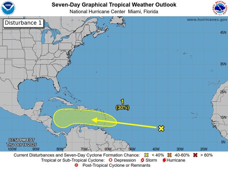
That area of interest, a tropical wave in the eastern Tropical Atlantic, was designated 98L by forecasters on Oct. 18. The rotation associated with this wave is strung out, and wind shear and nearby dry air will prevent development over the next 5 days as it continues westward along the 10th parallel north.
Once this wave reaches the Caribbean early next week, it will slow down as steering currents weaken and it encounters upper-level winds more favorable for development. As of Thursday afternoon, the NHC is giving this wave a 30% chance of becoming a depression in the central Caribbean by the 23rd, but the opportunity for a storm to form in the central or western Caribbean will persist into the final week of October.
Assuming that this wave can avoid landmasses and slowly organize in 6-10 days, it will swirl into existence with several opposing steering features nearby.
If a circulation consolidates in the southwestern Caribbean, subtropical ridging over the western Gulf could carry it into Central America. Formation closer to Hispaniola would likely result in a dip in the jet stream over the eastern U.S. and western Atlantic late next week accelerating a tropical storm to the northeast.
Developing in-between, in the west-central Caribbean? That could lead to days of slow motion over water, opening the door for a stronger storm, eventual fate unknown.
November hurricanes are rare in Florida but can still pack a punch
It’s too soon to know which of those scenarios (if any) will come to fruition. My sense is that something tropical will form in the Caribbean between the 22nd and 28th, as the seed wave looks robust, La Niña-fueled environmental conditions in the Caribbean are supportive, and most models do show eventual organization.
History favors the U.S. being spared, though, as late October and November hurricanes rarely approach Florida due to the west-to-east mid-latitude jet stream winds that normally encroach on the Gulf Coast at this time of year.
However, “normal” in the Tropics is a slippery concept in late October and November, as the storms that do form often blaze erratic paths like Li’l Billy traipsing across the “Family Circus” neighborhood.
While only four U.S. hurricane landfalls have occurred in November, the climatological weirdness of November storms like 1985’s Kate and 2022’s Nicole have been enabled by a La Niña-like tilt to late fall weather patterns in those years. A low chance of landfall is unfortunately not the same as no chance.
The bottom line is if the 2025 season only had one last shot to threaten land, would it seize it, or just let it slip by?
La Niña is back, back again, and that means that we’ll need to keep a close eye on the Caribbean until this disturbance is kaput, one way or another. Hurricanes have pitched a no-hitter so far, but to quote either Yogi Berra or Lenny Kravitz depending on your age, it ain’t over ‘til it’s over. Keep watching the skies.
(P.S. If you have a burning question about the 2025 hurricane season or tropical weather in general, drop me an email and I may answer it in my annual Stump the Tiger column, coming as soon as this wave is no longer a potential threat.)
Dr. Ryan Truchelut is chief meteorologist at WeatherTiger, a Tallahassee company providing forensic meteorology expert witness services and agricultural and hurricane forecasting subscriptions. Visit weathertiger.com to learn more. Email Truchelut at ryan@weathertiger.com.
This article originally appeared on Tallahassee Democrat: Late October hurricane forecast: Could reloaded La Niña, 98L interrupt our storm siesta?
Reporting by Ryan Truchelut / Tallahassee Democrat
USA TODAY Network via Reuters Connect