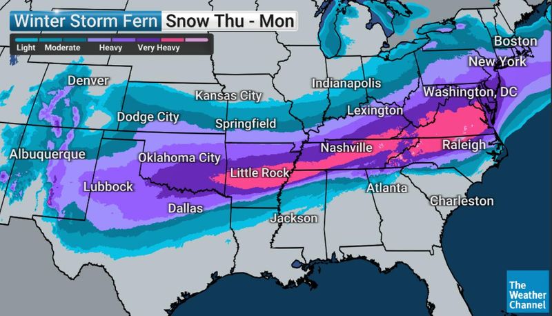
A widespread winter system known as Winter Storm Fern is expected to move from Texas toward the Northeast on Jan. 24–25, bringing snow and ice along its path. AccuWeather estimates the storm could impact more than 150 million people across more than two dozen states.
Before the chill settles in, temperatures across Florida will briefly warm during the workweek, according to the Florida Department of Emergency Management, with rain chances increasing by the weekend.

While Northeast Florida is not expected to see snow or ice from the storm itself, colder air will follow in its wake wit freezes projected for next week.
Will the winter storm impact Jacksonville area? Here’s what we know
➤ Weather alerts via text: Sign up to get updates about current storms and weather events by location
Could winter weather reach Jacksonville again?
For now, forecasters say winter weather is expected to stay north of the Florida line.
The National Weather Service is tracking a low (5% to 10%) chance of minor freezing rain impacts across parts of southeast Georgia, including the Waycross area, from Sunday into Sunday night. That risk has decreased in recent forecasts and is not expected to affect Jacksonville.
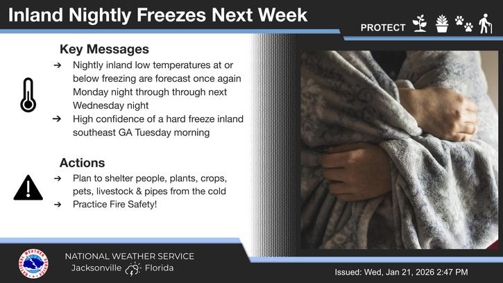
While snow and ice are unlikely locally, colder air behind the system could bring overnight freezes inland early next week, making it a good time to prepare plants, pets and pipes.
Freezing nights possible next week in Jacksonville
The National Weather Service says overnight freezes are expected inland from Monday night through Wednesday night, prompting officials to urge residents to prepare now for cold-weather impacts.
Weather alerts issued in Florida
NWS Jacksonville radar
Will it snow again in Florida? Are more freezing temperatures expected this weekend?
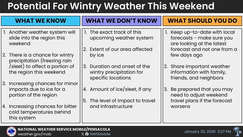
“There is a chance for wintry precipitation — freezing rain/sleet — that could affect a portion of the region this weekend,” Jan. 24-25, according to the National Weather Service Mobile.
As the weather system “slides” into the region over the weekend, there are “increasing chances for minor impacts due to ice for a portion of the region and increasing chances for bitter cold temperatures behind this system.”
However, forecasters warned there is a “lot of forecast uncertainty this far out. Will we get rain or will it be freezing rain/sleet is the big question.”
➤ Arctic cold overtakes US as huge winter storm looms
Forecasters with the National Weather Service in Tallahassee agreed “winter weather is possible this weekend as cold air returns to the Deep South.”
Another strong push of cold air will move into the Deep South next weekend but impact probabilities remain low for the Florida Panhandle and Big Bend region. “Bigger travel impacts are expected farther north.”
When will it get cold again in Florida?
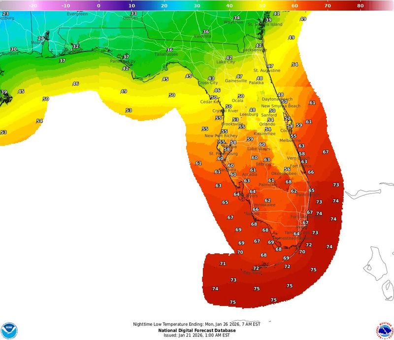
“Low temperatures will remain in the middle to upper 40s across North Florida, 50s across Central Florida and 60s across South Florida into Friday (Jan. 23) and Saturday, with North Florida warming up into the lower 50s Friday night,” according to the Florida Department of Emergency Management.
“But colder air begins to arrive Saturday night (Jan. 24) and into Sunday dropping low temperatures into the lower 40s along the Panhandle.”
What should Florida residents do when faced with uncertain weekend forecast?
The National Weather Service Mobile advised residents to:
AccuWeather forecasters said ‘massive winter storm’ could threaten travel, bring dangerous cold to dozens of states
“Arctic air is amassing in northern Canada and will surge into the central United States late this week and the weekend,” according to AccuWeather.
“A high-impact winter storm will spread snow and ice across more than two dozen states from Texas through the Carolinas and Massachusetts from Friday through the weekend.
“The amount and extent of snow and ice could cut power and disrupt travel for days, increasing the risk to lives and property.
“Potentially hundreds of thousands of people may go without electricity and heat for days,” AccuWeather Chief Meteorologist Jonathan Porter said.
“On the southern edge of the storm, near the Gulf coast and southern Atlantic coast, a few thunderstorms may rumble, with the potential for localized severe weather, perhaps centered on Florida.”
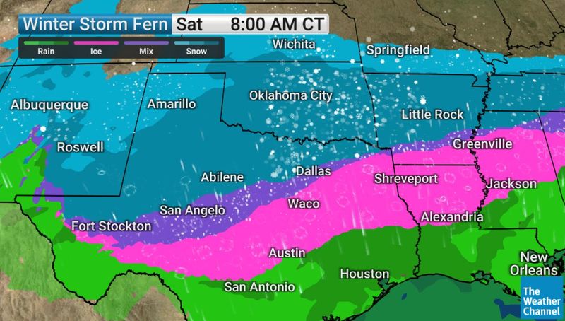
The Weather Channel warns residents need to prepare for Winter Storm Fern
“This is a plan-changing winter storm stretching from Texas through the Southeast and into the I-95 corridor, with significant impacts expected this weekend,” according to The Weather Channel meteorologist Stephanie Abrams via email Jan. 20.
“Travel conditions will deteriorate quickly as rain changes to ice, sleet, and snow, and widespread power outages are possible in areas that rarely deal with ice.
“What makes this storm especially dangerous is the lack of a warm-up afterward. Temperatures stay cold enough for refreezing day after day. People need to prepare now, finish travel early, and be ready for disruptions that could last well into next week.”
“As things stand, Florida will be the one state in the eastern U.S. that isn’t impacted by Winter Storm Fern. Of course, it’s still relevant for Floridian’s planning to travel to or from other states. In other words, if you’re in Florida, don’t plan on leaving,” The Weather Channel said via email.
What does Jim Cantore say about Winter Storm Fern?
“This storm has a dangerous sweet spot where crippling ice, heavy snow, and prolonged power outages all overlap, especially from the southern Plains into parts of the Southeast,” Jim Cantore, The Weather Channel meteorologist said via email Jan. 20.
“Some areas could see ice accretion approaching or exceeding an inch, and that is enough to take down trees, power lines, and entire transportation networks.
“The real concern is that this doesn’t end when the precipitation stops. An Arctic air mass follows, locking everything in place for days. That combination turns what might look like a short-term storm into a multi-day emergency.”
Forecast for Pensacola, Florida
“The potential for winter weather returns to portions of the forecast area this coming weekend as our next weather system moves in. Forecast trends will continue to be monitored over the coming days.
“In the wake of this weekends system, very cold temperatures will move into the region with overnight temperatures dipping into the lower 20s and wind chills in the teens,” according to the National Weather Service Mobile.
Low Monday night: 29
➤ Follow National Weather Service Mobile on X
Forecast for Tallahassee, Florida
“Even if we get no wintry precip in our forecast area, if you have plans to travel north this weekend toward Memphis, Birmingham, Nashville, Atlanta, North Carolina, or Virginia, keep tabs on what is shaping up to be a major winter storm,” according to the National Weather Service Tallahassee.
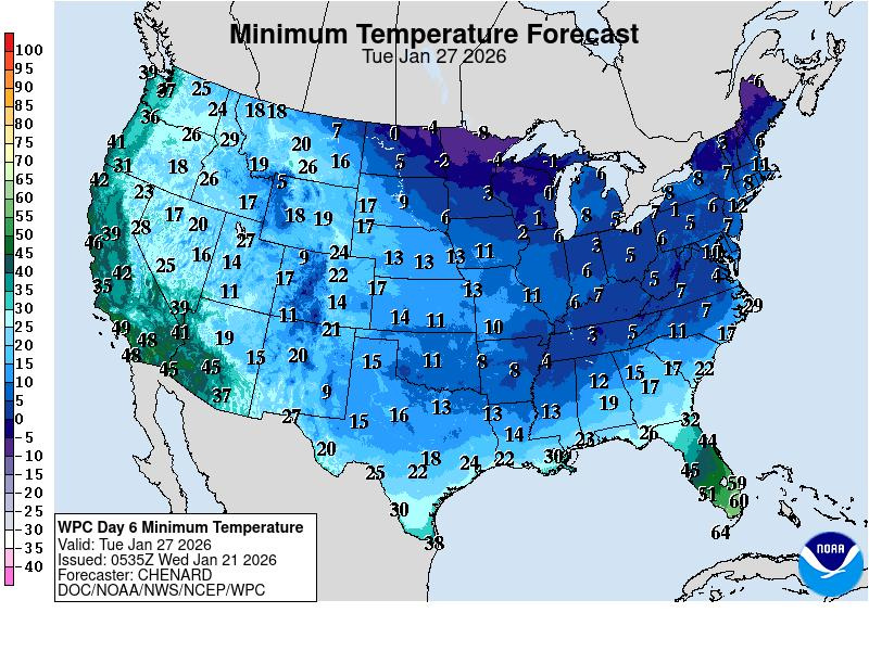
“The air mass affecting the region next Monday (Jan. 26) and Tuesday will be very cold. Expect hard freezes for all but the beaches on Tuesday morning.”
Low Monday night: 28
➤ Follow the National Weather Service Tallahassee on X
Forecast for Daytona Beach, Florida
“After a warming trend through this week and into the weekend, the next cold front looks to move across east central Florida on Monday, with a return of below-normal temperatures anticipated behind it,” according to the National Weather Service Melbourne.
Low Monday night: 45
➤ Follow the National Weather Service Melbourne on X
Forecast for Melbourne, Florida
“After a warming trend through this week and into the weekend, the next cold front looks to move across east central Florida on Monday, with a return of below-normal temperatures anticipated behind it,” according to the National Weather Service Melbourne.
Low Monday night: 52
➤ Follow the National Weather Service Melbourne on X
Forecast for Port St. Lucie, Florida
“After a warming trend through this week and into the weekend, the next cold front looks to move across east central Florida on Monday, with a return of below-normal temperatures anticipated behind it,” according to the National Weather Service Melbourne.
Low Monday night: 52
➤ Follow the National Weather Service Melbourne on X
Forecast for West Palm Beach, Florida
The latest forecast takes a blend of the models and introduces a slight chance of showers out ahead of the front on Monday, according to the National Weather Service Miami.
Low Monday night: 63
➤ Follow the National Weather Service Miami on X
Forecast for Miami, Florida
The latest forecast takes a blend of the models and introduces a slight chance of showers out ahead of the front on Monday, according to the National Weather Service Miami.
Low Monday night: 63
➤ Follow the National Weather Service Miami on X
Weather radar, forecast for Naples, Florida
The latest forecast takes a blend of the models and introduces a slight chance of showers out ahead of the front on Monday, according to the National Weather Service Miami.
Low Monday night: 52
➤ Follow the National Weather Service Miami on X
Forecast for Fort Myers, Florida
“The next cold front is expected to push across west central and southwest Florida late Sunday and Sunday night with a chance of showers, mainly across north and central areas,” according to the National Weather Service Tampa Bay. After the front moves through, expect cooler temperatures and gusty north winds.
Low Monday night: 50
➤ Follow the National Weather Service Tampa Bay on X
Forecast for Sarasota, Florida
“The next cold front is expected to push across west central and southwest Florida late Sunday and Sunday night with a chance of showers, mainly across north and central areas,” according to the National Weather Service Tampa Bay. After the front moves through, expect cooler temperatures and gusty north winds.
Low Monday night: 48
➤ Follow the National Weather Service Tampa Bay on X
Forecast for Orlando, Florida
“After a warming trend through this week and into the weekend, the next cold front looks to move across east central Florida on Monday, with a return of below-normal temperatures anticipated behind it,” according to the National Weather Service Melbourne.
Low Monday night: 43
➤ Follow the National Weather Service Melbourne on X
Stay informed. Get weather alerts via text
You can get all of Florida’s best content directly in your inbox each weekday day by signing up for the free newsletter, Florida TODAY, at https://heraldtribune.com/newsletters.
This article originally appeared on Florida Times-Union: Is winter storm expected to impact Jacksonville, Florida this weekend?
Reporting by Doris Alvarez Cea and Cheryl McCloud, Jacksonville Florida Times-Union / Florida Times-Union
USA TODAY Network via Reuters Connect