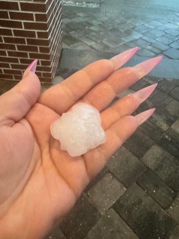
Hail the size of walnuts (and some bigger) pelted much of Tallahassee as thunder shook buildings and sheets of rain and wind gusts pounded the city’s downtown. The hailstorm lasted about 10 minutes, causing some downtown office workers near windows to flee their desks.
Hail as big as 1 inch was reported downtown, and as big as an inch-and-a-half in the city’s Indianhead neighborhood, for instance.

Ice balls accumulated on the ground as photos and video of the sudden storm ricocheted around social media.
“Got pegged right in the face,” one person wrote on social media.
“You haven’t lived until you’ve heard hail hitting a metal roof,” another wrote.
It started with a severe thunderstorm warning from the National Weather Service in Tallahassee at 3:36 p.m. on Wednesday, June 25. This warning also applied to Gadsden, Leon and Liberty counties. Meteorologists warned of winds as strong as 60 mph.
The NWS warned: “For your protection move to an interior room on the lowest floor of a building. To report severe weather, contact your nearest law enforcement agency. They will send your report to the National Weather Service office in Tallahassee.”
Flash flood warning issued at 5 p.m.
The National Weather Service in Tallahassee issued a Flash Flood Warning for Eastern Gadsden County and Leon County, according to a weather alert. It lasts to 8:15 p.m.
“Doppler radar indicated thunderstorms producing heavy rain across the warned area. Flash flooding is ongoing or expected to begin shortly,” it said. “Flash flooding of small creeks and streams, urban areas, highways, streets and underpasses as well as other poor drainage and low-lying areas.”
Locations mentioned include: Woodville, Tallahassee State College, Florida State University, Florida A&M, Midway, Havana, Quincy, Doak Campbell Stadium, Fred George Park, Lake Jackson, Mission San Luis, Griffin Heights, Messer Park, Levy Park, Macon Community Park, Frenchtown, Innovation Park, Forest Meadows Park and Lake Ella.
What are NWS meteorologists saying?
At 3:36 p.m., the NWS issued a statement:
“The National Weather Service in Tallahassee has issued a Severe Thunderstorm Warning for: Gadsden County in Big Bend Florida, Northwestern Liberty County in Big Bend Florida, Northeastern Leon County in Big Bend Florida, Until 5 p.m. EDT. At 3:36 p.m. EDT, a severe thunderstorm was located 9 miles northeast of Tallahassee, moving west at 25 mph.
HAZARD: 60 mph wind gusts and quarter size hail.
SOURCE: Radar indicated.
IMPACT: Hail damage to vehicles is expected. Expect wind damage to roofs, siding, and trees. Locations impacted include: Tallahassee, Midway, Quincy, Havana, Greensboro, Chattahoochee, Gretna, Bristol, Rock Bluff, Juniper, Douglas City, Florence, Jamieson, Miccosukee, Quincy Airport, Sawdust, Mount Pleasant, Baum, Orchard Pond, and Maclay State Gardens.”
What is a severe thunderstorm warning?
A severe thunderstorm warning means the area is experiencing or is about to experience a storm with winds of 58 mph or higher or hail an inch in diameter or larger.
Tips for staying safe during thunderstorms
This is a developing news story. Check back later for more.
Jana Hayes and Victoria Reyna-Rodriguez contributed to this article. The weather report was generated automatically using information from the National Weather Service. This story was written and reviewed by an editor.
This article originally appeared on Tallahassee Democrat: Hail pounds Tallahassee as severe storm rocks city
Reporting by Tallahassee Democrat / Tallahassee Democrat
USA TODAY Network via Reuters Connect