
Mother Nature is keeping life in Florida interesting.
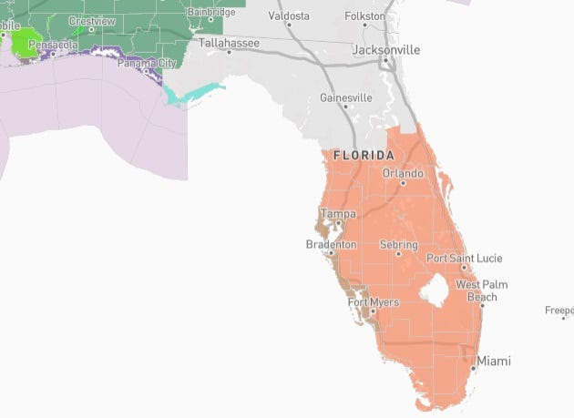
Most of the state’s peninsula is under a heat advisory June 18, while the western Panhandle faces a flood threat and potential of tornadoes from the remnants of former Tropical Storm Arthur.

Are you prepared for hurricane season and Florida weather?
➤ Weather alerts via text: Sign up to get updates about current storms and weather events by location
The heat index could reach 111 today across east-central Florida and 110 in South and Southwest Florida, according to the National Weather Service.
Here’s what you should know.
Shop Amazon for emergency supplies
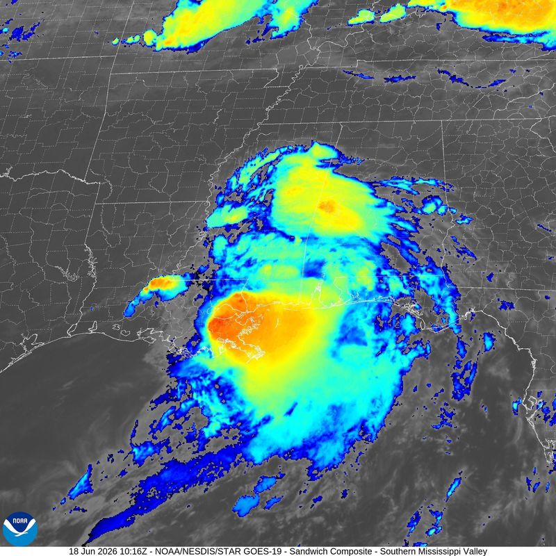
Where is Tropical Storm Arthur?
About 12 hours after becoming the first named storm of the 2026 Atlantic hurricane season, Tropical Storm Arthur is now a post-tropical cyclone. The National Hurricane Center issued its last advisory on Arthur at 11 p.m. June 17.
➤Track former Tropical Storm Arthur
“Life-threatening flooding” is expected to continue across the southeastern United States, with totals of 5 to 10 inches forecast. Some isolated amounts could reach 20 inches through June 19.
Areas expected to be impacted by what’s left of Arthur include the Mid and Upper Texas coast east-northeast into southern and central portions of Louisiana, Mississippi, and Alabama, and along with western portions of Georgia and the Florida Panhandle.
What can Florida expect from former Tropical Storm Arthur?
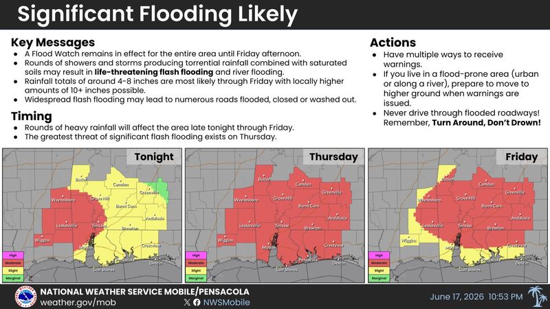
The western half of Florida’s Panhandle are under flood watches and warnings. Clusters of thunderstorms, some of which could become severe, are forecast to move through the western Panhandle June 18, according to the National Weather Service Mobile.
➤ WeatherTiger: Florida forecast calls for beneficial, flooding rain
The threat of a tornado can’t be ruled out.
Rainfall totals of 6 to 12 inches are most likely through June 19, with locally higher amounts of 15 inches or more possible, according to the National Weather Service Mobile.
Farther east, heavy rain and a threat of tornadoes are also expected in the central Panhandle, according to the National Weather Service Tallahassee.
National weather radar: Track storms moving across US
Weather alerts issued in Florida
Will it rain in Florida today?
Rain forecast for Florida over Juneteenth holiday weekend
Most of Florida faces dangerous heat today
The threat of tornadoes and flooding rain isn’t the only threat Florida residents are facing June 18.
Thirty-one of Florida’s 67 counties are under a heat advisory.
The heat index is expected to climb as high as 111 in some parts of the state.
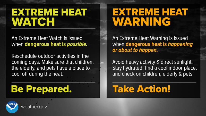
What is a heat advisory?
A heat advisory is one of several types of health alerts issued by the National Weather Service. A heat advisory is issued within 12 hours of the onset of extremely dangerous heat conditions.
In Florida, except for Miami-Dade County, the National Weather Services offices around the state issue a heat advisory if the heat index is expected to reach 108 to 112 degrees.
The National Weather Service Miami said Miami/Dade County wanted a lower threshold for an advisory for its population, which was set at 105 degrees.
What should you do if a heat advisory is issued?
The National Weather Service issues a heat advisory if dangerous heat conditions are not expected to reach warning criteria.
Here’s what you should do:
What types of heat alerts does National Weather Service issue?
The National Weather Service issues several types of heat-related advisories, including:
Criteria used in Florida for heat advisories, extreme heat warnings
Weather forecast, radar for Pensacola, Florida
A flood watch is in effect until 6 p.m. CT June 19. “Multiple rounds of heavy rainfall will continue through at least Friday (June 19) afternoon. Additional rainfall amounts of 6 to 12 inches are expected with locally in excess of 15 inches near the coast.
Today’s forecast: Showers and possibly a thunderstorm, mainly before 1 p.m., then showers and thunderstorms after 1 p.m. High near 84. Windy, with a south wind 20 to 25 mph, with gusts as high as 30 mph. Chance of precipitation is 100%. New rainfall amounts between 1 and 2 inches possible.
➤ Follow National Weather Service Mobile on X
Weather forecast, radar for Tallahassee, Florida
Additional rounds of heavy rain are expected June 18-19. High rain rates and training bands will increase the chance of dangerous to life-threatening flash flooding. A flood watch is in effect through June 19 generally near and west of a Panama City to Ashburn line for the potential for flash flooding, according to the National Weather Service Tallahassee.
A few tornadoes are possible today and Friday across the area with quick spin-ups in some rain bands.
Today’s forecast: A chance of showers and thunderstorms before 1 p.m., then showers likely and possibly a thunderstorm between 1 p.m. and 2 p.m., then a chance of showers and thunderstorms after 2 p.m. Partly sunny, with a high near 89. Heat index values as high as 102. South southwest wind 5 to 15 mph, with gusts as high as 30 mph. Chance of precipitation is 60%. New rainfall amounts of less than a tenth of an inch, except higher amounts possible in thunderstorms.
➤ Follow the National Weather Service Tallahassee on X
Weather forecast for Jacksonville, Florida
Building seasonably hot conditions through the weekend. Peak heat index between 100-107 degrees June 18. Daily thunderstorm chances continue June 19 and through the weekend, with strong to severe storms possible June 19.
Today’s forecast: A 40 percent chance of showers and thunderstorms, mainly after 2 p.m. Partly sunny, with a high near 94. Southwest wind 7 to 11 mph, with gusts as high as 20 mph.
➤ Follow the National Weather Service Jacksonville on X
Weather forecast for Daytona Beach, Florida
A heat advisory is in effect from 11 a.m. to 7 p.m. June 18. Heat index values up to 110 expected.
Today’s forecast: A 30 percent chance of showers and thunderstorms, mainly after 3 p.m. Mostly sunny, with a high near 93. Heat index values as high as 106. South southwest wind 5 to 10 mph, with gusts as high as 20 mph.
➤ Follow the National Weather Service Melbourne on X
Weather forecast for Melbourne, Florida
A heat advisory is in effect from 11 a.m. to 7 p.m. June 18. Heat index values up to 110 expected.
Today’s forecast: A 30 percent chance of showers and thunderstorms after 2 p.m. Mostly sunny, with a high near 92. Heat index values as high as 106. South wind 5 to 15 mph.
➤ Follow the National Weather Service Melbourne on X
Weather forecast for Port St. Lucie, Florida
A heat advisory is in effect from 11 a.m. to 7 p.m. June 18. Heat index values up to 110 expected.
Today’s forecast: A 30 percent chance of showers and thunderstorms, mainly between 4 p.m. and 5 p.m. Mostly sunny and hot, with a high near 97. Heat index values as high as 110. Light south wind becoming southeast 5 to 10 mph in the morning.
➤ Follow the National Weather Service Melbourne on X
Weather forecast for West Palm Beach, Florida
A heat advisory is in effect from noon to 7 p.m. June 18. Heat index values up to 110 expected.
Today’s forecast: Mostly sunny, with a high near 87. Heat index values as high as 100. Breezy, with a southeast wind 8 to 16 mph, with gusts as high as 20 mph.
➤ Follow the National Weather Service Miami on X
Weather forecast for Miami, Florida
A heat advisory is in effect from noon to 7 p.m. June 18. Heat index values up to 110 expected.
Today’s forecast: Mostly sunny, with a high near 90. Heat index values as high as 105. Southeast wind 8 to 13 mph.
➤ Follow the National Weather Service Miami on X
Weather forecast for Naples, Florida
A heat advisory is in effect from noon to 7 p.m. June 18. Heat index values up to 110 expected.
Today’s forecast: Mostly sunny, with a high near 92. Heat index values as high as 109. South wind 6 to 14 mph, with gusts as high as 21 mph.
➤ Follow the National Weather Service Miami on X
Weather forecast for Fort Myers, Florida
A heat advisory is in effect from 11 a.m. until 7 p.m. June 18. Heat index values up to 110 expected.
Today’s forecast: Mostly sunny, with a high near 94. Heat index values as high as 106. Southeast wind 6 to 11 mph becoming south southwest in the afternoon.
➤ Follow the National Weather Service Tampa Bay on X
Weather forecast for Sarasota, Florida
A heat advisory is in effect from 11 a.m. until 7 p.m. June 18. Heat index values up to 110 expected.
Today’s forecast: Mostly sunny, with a high near 90. Heat index values as high as 100. Breezy, with a south southwest wind 10 to 17 mph, with gusts as high as 21 mph.
➤ Follow the National Weather Service Tampa Bay on X
Weather forecast for Tampa, Florida
A heat advisory is in effect from 11 a.m. until 7 p.m. June 18. Heat index values up to 110 expected.
Today’s forecast: Mostly sunny, with a high near 94. Heat index values as high as 107. Southwest wind 6 to 11 mph, with gusts as high as 18 mph.
➤ Follow the National Weather Service Tampa Bay on X
Weather forecast for Orlando, Florida
A heat advisory is in effect from 11 a.m. to 7 p.m. June 18. Heat index values up to 110 expected.
Today’s forecast: A 30 percent chance of showers and thunderstorms, mainly after 3 p.m. Mostly sunny and hot, with a high near 96. Heat index values as high as 106. South wind 5 to 10 mph.
➤Follow the National Weather Service Melbourne on X
Stay informed. Get weather alerts via text
What’s next?
We will provide weather coverage as conditions warrant. Download your local site’s app to ensure you’re always connected to the news. And look for our special subscription offers here.
Cheryl McCloud is a journalist for the USA TODAY Network-Florida’s service journalism Connect team. You can get all of Florida’s best content directly in your inbox each weekday day by signing up for the free newsletter, Florida TODAY, at https://news-journalonline.com/newsletters.
This article originally appeared on The Daytona Beach News-Journal: Extreme heat, floods, possible tornadoes today’s Florida weather threats
Reporting by Cheryl McCloud, USA TODAY NETWORK – Florida / The Daytona Beach News-Journal
USA TODAY Network via Reuters Connect

By Cheryl McCloud, USA TODAY NETWORK – Florida | USA TODAY Network