PANAMA CITY — July 28 got hot in Bay County, with even higher heat indices expected on July 29.

As Alert Bay sends out heat advisory notifications, forecasters are urging residents to stay in a cool place during daytime heat, use air conditioning where available, and stay hydrated.
Bay County has opened a cooling station that will remain in operation through Aug. 1. Find details here.
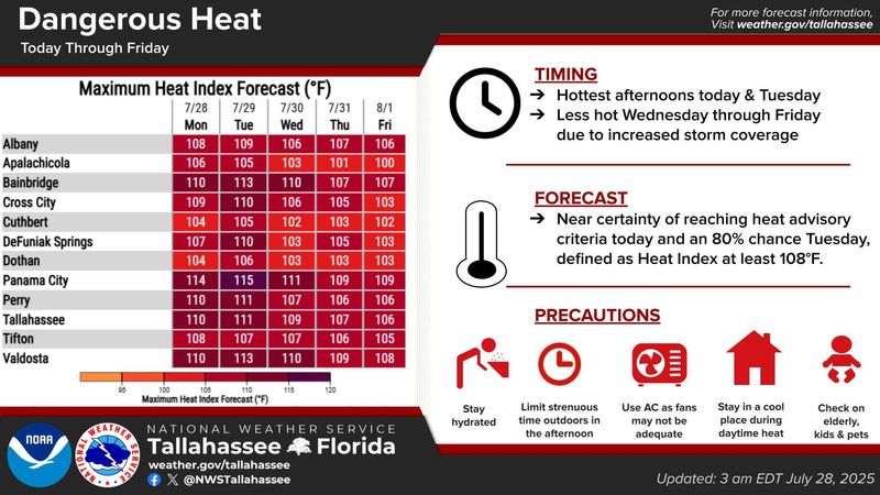
Maximum heat index forecasts for July 28 from the National Weather Service were as high as 114. AccuWeather reported a real-feel temperature of 116 about 1:30 p.m.
Maximum indices on July 29 were forecast to be as high as 115, with an extreme heat watch in effect.
A meteorologist at the NWS Tallahassee forecasting office told the News Herald that although the air temperature is expected to decrease on July 29, moisture contributing to the humidity will drive up the heat index.
Daily showers and thunderstorms are expected to resume after July 29, offering a small relief from the extreme heat. Maximum indices for the rest of the week are still dangerous but slightly cooler, expected to sit around 110.
In the local forecast discussion, an NWS meteorologist said they expect the streak of dangerous temperatures to end on Aug. 1, making way for heavy rainfall over the weekend.
The Climate Prediction Center anticipates above-average temperatures and precipitation in the near future.
This trend of dangerous temperatures is affecting the entire Southeast and beyond, as more than 100 million people were under a major heat risk on July 28.
This article originally appeared on The News Herald: Dangerous temperatures to persist in Bay County amid national heat wave
Reporting by Dylan Gentile, Panama City News Herald / The News Herald
USA TODAY Network via Reuters Connect