A powerful winter storm is set to hit California’s mountains beginning Monday night, bringing heavy snow, falling snow levels and dangerous travel conditions through midweek.
Forecasters say multiple systems will move across the state, with the most disruptive impacts expected in the Sierra Nevada and the mountains of northwest California.

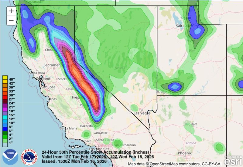
“A pair of potent Pacific storm systems are working together to direct copious amounts of moisture at the mountain ranges of the ‘Golden State,'” the Weather Prediction Center wrote. “While heavy snow has been unfolding in the Siskiyou, Shasta, Trinity and Salmons mountains of northern California since Sunday, today marks the beginning of very heavy snowfall along the Sierra Nevada with snow levels initially starting out around 6,000 feet, then falling to as low as 3,000 feet by Monday night in the northern Sierra and 4,000 ft for the southern Sierra Nevada.”
How much snow is expected?
In northwest California, 6 to 18 inches are expected above 2,000 to 3,000 feet, with higher totals at higher elevations in Del Norte and Humboldt counties.
Across the Sierra Nevada, snowfall will be measured in feet above 4,000 feet through Thursday morning. Forecast probabilities show a high chance of more than 30 inches near Donner Pass by early Thursday, with more snow possible beyond that.
Some brief snowflakes could mix in at the coast in places like Eureka or Arcata, though accumulation is not expected there. Small hail is possible along the northwest coast Tuesday, which could create slick roads.
When will snow begin in California?
Light showers will linger through Monday, but colder air is expected to dive south by Monday evening, Feb. 16. By Monday evening, snow will begin in northwest California as snow levels fall rapidly.
Late Monday night into Tuesday morning, Feb. 17, the heaviest snow is expected in Humboldt and Del Norte counties, according to the National Weather Service in Eureka. Dangerous travel conditions are likely on highways 199, 299, 36 and 3, with possible impacts on Highway 101 as well.
On Tuesday, very heavy snow will develop along the Sierra Nevada, including Donner Pass, with snowfall rates of 1 to 3 inches per hour in some areas. Snow will continue Tuesday night into Wednesday, with colder air pushing snow levels even lower.
Another round of rain and mountain snow is possible Wednesday night into Thursday, keeping conditions hazardous in higher elevations.
California snow totals map: Search by address
New York snow totals: Search by address
USA TODAY’s snowfall map shows accumulation over the past 24, 48, and 72 hours, as well as seasonal totals dating back to Oct. 1. Updated multiple times a day, the map lets you toggle between timeframes to see how snow is adding up in your area.
California weather watches and warnings
Stay informed. Get weather alerts via text
Brandi D. Addison covers weather across the United States as the Weather Connect Reporter for the USA TODAY Network. She can be reached at baddison@gannett.com. Find her on Facebook here.
This article originally appeared on Palm Springs Desert Sun: Winter storm watch over parts of California. See timing, maps
Reporting by Brandi D. Addison, USA TODAY NETWORK / Palm Springs Desert Sun
USA TODAY Network via Reuters Connect