El Niño is coming “soon” and it could reach “very strong” levels later this year, according to a May 14 forecast released by climate scientists from NOAA’s Climate Prediction Center. California may feel the impacts as Pacific storm activity is expected to ramp up under El Niño conditions.
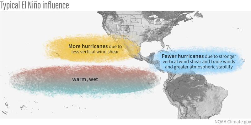
This and other forecasts are raising alarms globally because of the pattern’s powerful influence over the world’s weather. This includes its often dramatic impact on hurricanes, where it can suppress the number of storms that form in the Atlantic basin but boost those in the Pacific.

NOAA’s forecast said that El Niño is likely to emerge soon (with an 82% chance the next 2-3 months) and continue through the Northern Hemisphere winter of 2026-27 (a 96% chance by December 2026 – February 2027).
Also, even if the strongest part of the El Niño doesn’t arrive until the end of the year, it could still be strong enough during the hurricane season (June-November) to impact the number of storms that form in both the Atlantic and Pacific oceans.
What is a ‘Super’ El Niño?
Not all El Niño events are created equal. Some are mild and have only localized effects, while others can dramatically reshape weather patterns across the globe. What makes a “Super” El Niño different is its intensity and the scope of its influence.
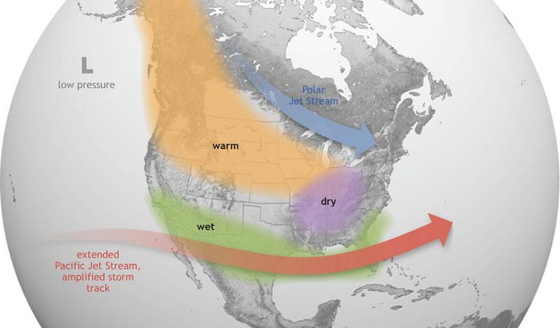
A stronger El Niño brings more intense warming of the central and eastern Pacific Ocean, which can significantly alter the jet stream. This shift affects weather systems far beyond the tropics, increasing the likelihood of widespread impacts across multiple continents. Scientists also have higher confidence in predicting the potential consequences when an event reaches this strength.
If this system continues to gain strength through summer and fall, it could rival — or even surpass — some of the most powerful events in modern records, including the 1997–98 and 2015–16 El Niños. Those events produced notable global effects, from extreme rainfall and flooding in some regions to droughts and heat waves in others.
How El Niño impacts weather in California
In California, El Niño typically tilts the odds toward a wetter-than-average winter. Storm systems track farther south across the Pacific, increasing the chances for repeated rounds of rain — sometimes over the same areas in a short period of time. That pattern can raise the risk of flooding, especially in regions where soils become saturated quickly.
The impact is often most pronounced in Central and Southern California, where stronger Pacific storms can bring periods of heavy rainfall. In these areas, runoff can build quickly, increasing the potential for flash flooding, river rises and debris flows, particularly near burn scars left behind by wildfires.
During summer, California can still experience brief periods of rainfall risk tied to Eastern Pacific tropical activity. During an active Pacific hurricane season, remnants of tropical systems can occasionally track north toward Southern California, sending bursts of tropical moisture into the region.
According to the Climate Prediction Center, large-scale climate patterns such as ENSO — a climate pattern in the tropical Pacific that shifts between cold and warm phases — can influence the environment for Eastern Pacific hurricane development by affecting factors like vertical wind shear and storm tracks.
When tropical moisture reaches California, it is typically short-lived but can produce intense downpours when it interacts with seasonal heat or passing atmospheric disturbances. These events are most likely to cause localized flash flooding in desert regions, burn scars and areas with limited drainage capacity.
Along the coast, periods of elevated tropical activity can also increase the risk of coastal flooding and beach erosion when swell, tides and intermittent rainfall overlap, even without a direct landfalling storm.
Warmer Pacific fuels storms that can impact California with heavy rain
The 2026 Pacific hurricane season is expected to be more active than average, driven by a combination of unusually warm ocean waters and broader climate patterns shaping the eastern Pacific. Forecasters warn that California faces higher risk of flooding this year.
AccuWeather expects 17 to 22 named storms in the Eastern Pacific this season, along with nine to 13 hurricanes and four to eight major hurricanes. The forecast also calls for six to nine direct impacts to Mexico and Central America — more than double the historical average.
Forecasters point to persistent above-average sea surface temperatures across the region — part of a marine heat wave — as a key factor providing additional energy for tropical cyclone development and intensification. When ocean waters are warmer than normal, storms have more fuel to strengthen and can maintain intensity longer over open water.
At the same time, the transition toward an ENSO-neutral to weak El Niño-like pattern can influence the atmospheric setup across the Pacific. During these conditions, vertical wind shear can periodically decrease in parts of the basin, creating a more favorable environment for storms to organize.
While California is not typically in the direct path of tropical cyclones, this combination can increase the chances that remnants of Eastern Pacific storms track farther north or send tropical moisture into Southern California. When that moisture interacts with existing weather systems, it can contribute to periods of heavy rainfall and raise the risk of flash flooding, particularly during late-season setups.
Stay informed. Get weather alerts via text
Brandi D. Addison covers weather across the United States as the Weather Connect Reporter for the USA TODAY Network. She can be reached at baddison@gannett.com. Find her on Facebook here.
This article originally appeared on Palm Springs Desert Sun: New data signals strong El Niño likely — what it means for California
Reporting by Brandi D. Addison and Doyle Rice, USA TODAY NETWORK / Palm Springs Desert Sun
USA TODAY Network via Reuters Connect