
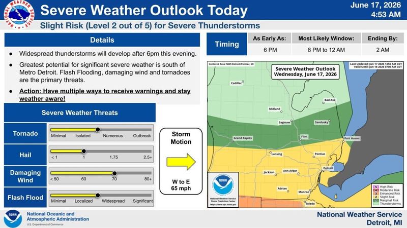
Michigan is forecast another round of thunderstorms Wednesday, June 17, and forecasters say this set of storms will be stronger than Tuesday’s, bringing heavy rain, possible tornadoes, hail and damaging winds.
A line of storms will move in Wednesday afternoon and evening, June 17, lingering into late hours while sweeping west to east across Michigan, the National Weather Service says.

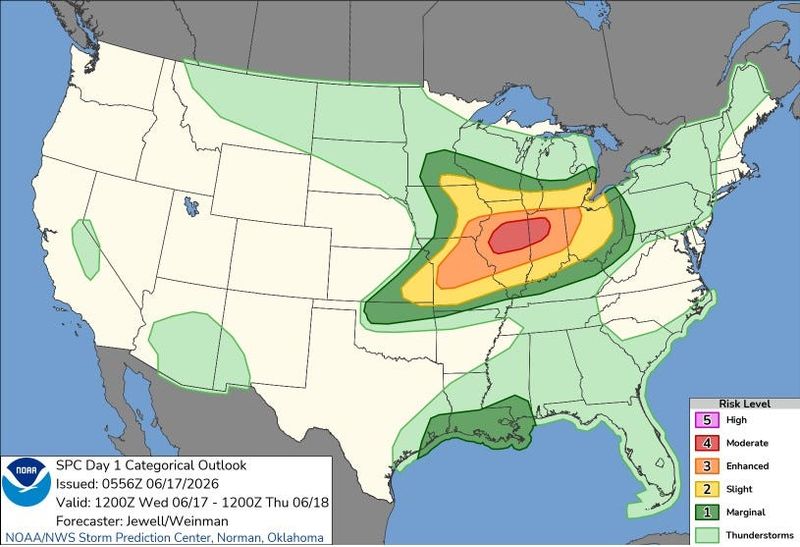
The southern half of the Lower Peninsula has the highest risk to see the worst conditions, including 1-inch hail, 70 mph wind gusts, flash flooding and potential isolated tornadoes, according to the Detroit National Weather Service.
“Thunderstorms will develop after 6pm this evening and scattered storms may be strong to severe. Flash flooding, damaging wind, and tornadoes are the primary threats. Have multiple ways to receive warnings tonight and stay weather aware!” the weather service said on X on June 17.
The southern Lower Peninsula is forecast to see the heaviest rain, including Detroit, Ann Arbor, Kalamazoo, Jackson, Niles, Three Rivers and others where 2.5 inches could fall, although amounts could be higher in localized or flood-prone areas, according to the Probabilistic Precipitation Portal.
A flood watch is in effect for portions of the southern L.P. through Wednesday, June 17. Small craft advisories are in place for much of the Lake Michigan and Lake Huron shorelines.
In Detroit, thunderstorms are expected to arrive as early as 5-6 p.m. and linger overnight, tapering off around 2 a.m. Rain may develop in the early afternoon.
In Lansing, storms are expected to begin about 4 p.m. and end by 10 p.m. Grand Rapids residents may expect storms around 4-5 p.m. and linger until 10 p.m. Rain will persist overnight through Thursday morning, June 18.
“Rain and thunderstorms Wed afternoon-evening. Some damaging winds or large hail possible. A tornado can’t be ruled out in southern Michigan, but the greater threat is in Illinois and Indiana. Flooding is possible in southern Michigan as a few inches of rain may fall quickly,” the Grand Rapids weather office said on X on June 17.
Cities in the northern Lower Peninsula and the Upper Peninsula are forecast to get rain showers on Wednesday, June 17, in the early morning and early afternoon with thunderstorms possible.
Residents are urged to ensure multiple ways of receiving weather alerts through the day and night and review their severe weather emergency plans.
Here’s the live radar and map of currents weather warnings in Michigan:
What does the Michigan live Doppler weather radar show?
Current weather warnings, watches in Michigan
Contact Sarah Moore @ smoore@lsj.com
This article originally appeared on Lansing State Journal: Severe weather possible today. See Doppler weather radar, warnings
Reporting by Sarah Moore, USA TODAY NETWORK / Lansing State Journal
USA TODAY Network via Reuters Connect
By Sarah Moore, USA TODAY NETWORK | USA TODAY Network