
The Midwest faces a significant tornado threat Wednesday, experts said.
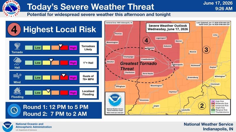
Abnormally strong summer winds are predicted to cause hail and over 70 mph winds in much of central Illinois and Indiana, according to a morning June 17 release by the National Weather Service.

“This is not a normal mid-June system,” said meteorologist Chris Hogue of Wilmington.
While Cincinnati is expected to receive some wind and rain, experts said current models do not show as significant a threat to the region as that faced by parts of Indiana and Illinois.
When will tornadoes begin in the Midwest?
Recent warmth, humidity and wind have caused an “anomalously higher threat” than usual for tornadoes, Hogue said.
Most severe weather in Illinois and Indiana is expected between 7 p.m. and 2 a.m., officials said. A smaller system will pass through beginning around noon to 5 p.m.
Cincinnati faces an increased risk of severe thunderstorms starting around midnight, Hogue said. Gusts could caused down powered lines. But the highest risk remains northwest of the Queen City, he said.
“Maybe once a year you might get a system like this,” Hogue said.
He encouraged the public to stay informed as the storm develops and be ready to take action if necessary.
This article originally appeared on Cincinnati Enquirer: ‘Not a normal mid-June system.’ Storms impact Indiana, Illinois, Ohio
Reporting by Matthew Cupelli, Cincinnati Enquirer / Cincinnati Enquirer
USA TODAY Network via Reuters Connect
By Matthew Cupelli, Cincinnati Enquirer | USA TODAY Network