
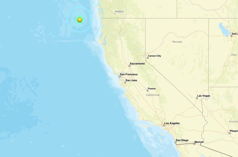
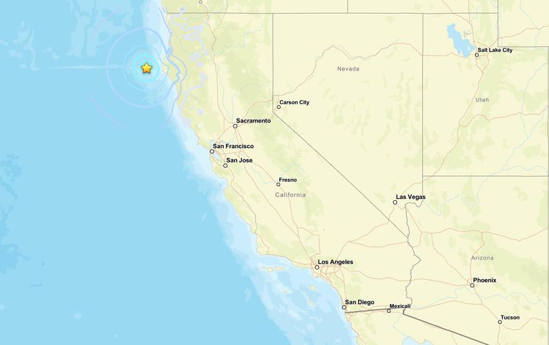
A series of moderate earthquakes rattled the waters off the West Coast early June 4 near the Mendocino Triple Junction, where three tectonic plates meet off Northern California’s coast, one of the most seismically active regions in the United States.
They included a magnitude 5.7 quake off the coast — about 120 miles from McKinleyville — and a magnitude 5.1 earthquake west of Petrolia, though no tsunami threat or significant damage was reported.

According to the U.S. Geological Survey, the strongest earthquake struck just before 4 a.m. Pacific time west-southwest of Pistol River, Oregon. About two hours later, a magnitude 5.1 earthquake hit roughly 40 miles west of Petrolia in Humboldt County. Minutes after the Petrolia-area quake, a magnitude 4.5 aftershock struck in nearly the same location.
Preliminary USGS data showed the Petrolia earthquakes occurred at very shallow depths beneath the seafloor.
The U.S. Tsunami Warning Center said no tsunami warning, advisory, watch or threat was issued following the earthquakes. USGS impact estimates also indicated a low likelihood of significant damage.
More: Tropical Storm Amanda is first named storm in 2026: See where it is
USGS earthquake map: 5.7 magnitude map hits 126 miles from McKinleyville
5.1 magnitude hits 40 miles west of Petrolia
What causes earthquakes?
The Earth has four layers: the inner core, outer core, mantle and crust. The crust and top of the mantle make up another area called the “lithosphere,” which acts like a skin surrounding the Earth’s surface.
The lithosphere, however, is not in one piece and exists like a puzzle or series of fragments, according to the USGS. These parts of the lithosphere are not stationary and move slowly. These are called “tectonic plates.”
As the tectonic plates move and shift past one another, they occasionally bump or collide. This places stress on the plates’ edges. When the stress becomes too great, it creates cracks called “faults.” The point where these faults move against each other is called the “fault line.”
When there is too much friction between the fault lines, energy is released suddenly, triggering seismic waves which lead to an earthquake.
Why are earthquakes so common in California?
California sits along one of the most active tectonic boundaries in North America, where the Pacific Plate and the North American Plate slowly grind past each other. That constant movement builds up stress in the Earth’s crust, which is released as earthquakes when rocks suddenly slip along faults.
The state is home to more than 500 active faults, according to geologists, making it one of the most earthquake-prone states in the nation.
The best-known is the San Andreas Fault, which stretches roughly 800 miles through much of the state and forms the boundary between the Pacific and North American tectonic plates. Other major fault systems include the Hayward Fault, Calaveras Fault, San Jacinto Fault and Elsinore Fault.
Many of California’s earthquakes occur along these fault systems, though quakes can also happen offshore, including near the Mendocino Triple Junction off the North Coast, where three tectonic plates meet.
What is California’s Earthquake Early Warning system?
California’s Earthquake Early Warning system uses seismic sensors, ground-motion monitoring and alerting technology to deliver warnings to people via cell phones before the strongest shaking arrives, according to the official website.
Officials say even a brief warning can allow people to take protective actions such as “Drop, Cover and Hold On,” or put devices and systems into a safe mode. In some cases, alerts may arrive just as shaking begins or after an earthquake has already passed, particularly for those closer to the epicenter.
The system is delivered through multiple channels, including Android Earthquake Alerts, Wireless Emergency Alerts and the MyShake app.
Developed by the UC Berkeley Seismological Laboratory, MyShake is a free smartphone application that issues audio and visual warnings for earthquakes typically magnitude 4.5 or greater, or when weak shaking is expected. It is available on iPhone and Android devices, as well as select computer platforms.
Can earthquakes be predicted?
Earthquakes are not predicted. Neither the U.S. Geological Survey, nor scientists, have predicted a major earthquake, and there’s no expectation for that to change in the near future.
Are earthquakes increasing?
While it might seem like earthquakes are happening more often, especially with real-time alerts and widespread media coverage, the overall rate of earthquakes has remained relatively stable over time.
According to the U.S. Geological Survey, any year may appear more active due to improvements in technology that allow scientists to detect more small quakes than in the past — not because there are actually more earthquakes occurring.
Long-term global records dating back to 1900 show that the Earth averages about 16 major earthquakes (magnitude 7.0 or greater) each year — typically 15 in the 7.0 range and one magnitude 8.0 or higher. In 2024, there were 10 earthquakes of magnitude 7.0 or greater, the strongest being a 7.5 in Japan.
However, the risk of being affected by an earthquake is growing because of increasing human and economic exposure and the number of assets being built in high earthquake hazard areas, the Federal Emergency Management Agency said in a report in 2023.
What to do during an earthquake
Classic evergreen box that pairs well with any quake story.
Stay informed. Get weather alerts via text
Contributing: Olivia Munson, USA TODAY
Brandi D. Addison covers weather across the United States as the Weather Connect Reporter for the USA TODAY Network. She can be reached at baddison@gannett.com.
This article originally appeared on Palm Springs Desert Sun: Magnitude 5.7 and 5.1 earthquakes shake California. Here’s where
Reporting by Brandi D. Addison, USA TODAY NETWORK / Palm Springs Desert Sun
USA TODAY Network via Reuters Connect
By Brandi D. Addison, USA TODAY NETWORK | USA TODAY Network