Tallahassee residents can expect a stormy start to the week with the threat of heavy rain and possible flooding Sunday, followed by rising heat and humidity into Monday.
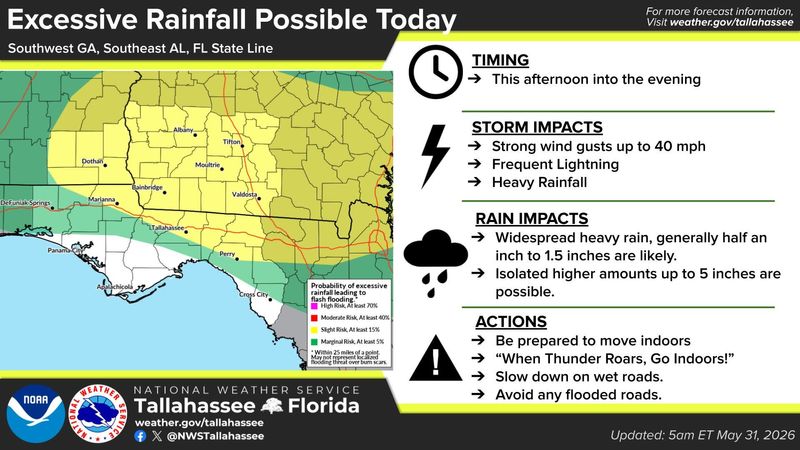
National Weather Service Forecasters in Tallahassee say an “active day” is expected Sunday, with scattered to numerous showers and thunderstorms developing during the afternoon and evening. The storms could produce heavy rainfall capable of flash flooding, particularly across parts of southwest Georgia, southeast Alabama and northern Florida.

Rainfall totals are expected to range from about a half-inch to 1.5 inches across the region, with isolated areas seeing several inches more. Some locations, particularly north of the Florida line, could see significantly higher amounts – up to 5 inches – in a short period of time.
The National Weather Service has placed parts of the region, including much of Tallahassee under a “slight risk” for excessive rainfall (a level 2 of 4), meaning flooding could occur in vulnerable areas.
Storms are expected to be most active through the afternoon into the evening, bringing hazards that include gusty winds up to about 40 mph, frequent lightning and periods of heavy rain, according to the agency.
Drivers are urged to slow down on wet roads and avoid flooded areas, while residents should move indoors when thunderstorms develop.
Waves of rain on Saturday made for a waterlogged elimination round for the Florida State Seminoles, who are hoping to advance in the NCAA tournament. The game against Coastal Carolina, with FSU up 2-1, was suspended after two weather delays that paused play for over four hours. The final four innings of the game will be played on Sunday morning starting at 11 a.m.
The winners’ bracket game between Northern Illinois and St. John’s will be played Sunday afternoon at 2 p.m., after the conclusion of the Seminoles game vs. Coastal Carolina. Sunday’s second elimination game is scheduled for 6 p.m. The forecast may again play havoc with the schedule.
Storms taper, heat builds into Monday
After Sunday’s widespread rain, precipitation chances will decrease early in the week as a frontal boundary sags south. Rain will become more confined to typical afternoon sea breeze storms by midweek, forecasters said.
At the same time, temperatures will climb.
Highs across the Tallahassee area are expected to reach the upper 80s to low 90s through Monday, with humidity pushing heat index values – what it feels like outside – into the upper 90s and low 100s.
The hottest conditions are expected Monday, before slightly cooler and drier air filters in later in the week.
By midweek, a drier pattern is expected to take hold, bringing slightly lower temperatures and fewer storms.
In the meantime, forecasters emphasized that Sunday will likely be the most impactful weather day, with the greatest risk for flooding rainfall before the transition to a hotter, more typical early-summer pattern.
Portions of this weather report were generated automatically using information from the National Weather Service and a story written and reviewed by an editor.
This article originally appeared on Tallahassee Democrat: Tallahassee could see heavy rain Sunday as heat rises
Reporting by Staff reports, Tallahassee Democrat / Tallahassee Democrat
USA TODAY Network via Reuters Connect