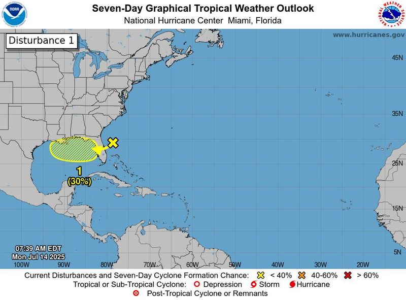
An area of low pressure off the east coast of Florida is forecast to move west and could become a tropical cyclone, but it is not expected to have direct impacts to South Texas, according to the National Weather Service Corpus Christi.
The area of disorganized showers and thunderstorms could cause heavy rainfall and flash flooding in parts of Florida. Environmental conditions could spur “gradual development” of the system, leading the National Hurricane Center to give it a 30% chance of becoming a tropical cyclone in the next seven days, the local office of the National Weather Service said in an email on July 14.

This system is then forecast to move west-northwestward toward the central Gulf of Mexico, renamed by the U.S. government as the Gulf of America, in the middle to latter-half of this week.
Low chances of rain are expected in South Texas this week, mainly across the Victoria Crossroads, according to the weather service. Chances are expected to be lowest on July 17, at 5%. The highest chances of rain, 20%, are expected on July 15 and July 18.
The Atlantic hurricane season began on June 1 and will last through the end of November.
Active hurricane weather typically peaks between mid-August and mid-October.
Check out the Caller-Times’ guide on how to prepare for hurricanes, which includes tips for preparing your home, packing an emergency kit and what to do during a hurricane warning.
This article originally appeared on Corpus Christi Caller Times: A low-pressure system near Florida is expected to move west. Will it affect South Texas?
Reporting by Corpus Christi Caller Times / Corpus Christi Caller Times
USA TODAY Network via Reuters Connect