
CENTRAL WISCONSIN – Residents in central Wisconsin can expect heat, humidity and a chance of storms during the week of June 8 as an unsettled weather pattern moves through the area.
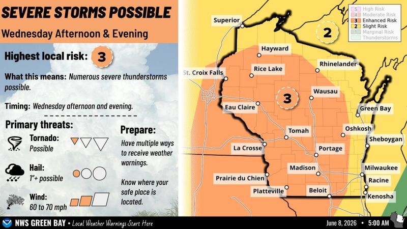
High temperatures and humidity will build through Wednesday, June 10, when central Wisconsin also faces an enhanced risk of severe weather from Wednesday afternoon into the evening, said Timm Uhlmann, a meteorologist with the National Weather Service in Green Bay.

Potential storms Wednesday are expected to form west of central Wisconsin near the Minnesota and Iowa borders before moving east in a line or bow, Uhlmann said. The storms may produce hail up to an inch or larger as they develop, but by the time they reach central Wisconsin, the main concern will be damaging winds, he said.
Wednesday’s storm may also bring a small chance for tornado threats but it is too early to predict where the higher risk areas would be, Uhlmann said.
The timing of the June 8 storm remains uncertain. It could form early in the afternoon and move out of the region by early evening, or it could develop later and remain in the area until later in the evening, Uhlmann said.
What can Central Wisconsin residents expect for continued high temperatures?
High temperatures and humidity are expected to build through Monday, June 8, and Tuesday, June 9, before reaching a peak on June 10 before cooling off over the following days, Uhlmann said. The conditions will also bring a chance for rain each day.
“We’re kind of in an unsettled pattern here; very summery where we get some rain or storms each afternoon and evening,” Uhlmann said. “Even with Wednesday kind of the highlight currently in terms of severe, there is plenty of active weather around.”
Rain is expected in the Central Wisconsin region on June 8 and 9 before humidity, severe weather chance, and temperatures in the 90s are expected on June 10, Uhlmann said.
June 11 and 12 will still see potential for rain and storms but temperatures will begin to fall with highs in the mid-80s expected for Thursday, highs in the low-80s on Friday and highs in the 70s expected for the weekend.
Erik Pfantz covers local government and education in central Wisconsin for USA TODAY NETWORK – Wisconsin and values his background as a rural Wisconsinite. Contact him at epfantz@usatodayco.com.
This article originally appeared on Stevens Point Journal: Severe weather in the forecast as Central Wisconsin heats up this week
Reporting by Erik Pfantz, Stevens Point Journal / Stevens Point Journal
USA TODAY Network via Reuters Connect
By Erik Pfantz, Stevens Point Journal | USA TODAY Network