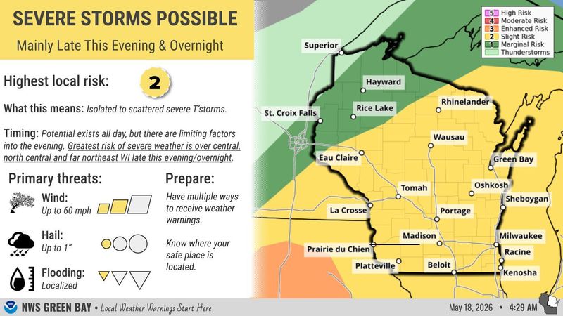
Central Wisconsin will see a small chance of storms overnight Monday, May 18, and cool temperatures for the rest of this week with rain likely again on Friday, May 22.
A complex of storms will move into the central Wisconsin area from the west near midnight on May 18, which could bring heavy downpours, gusty winds up to 40 mph, lightning and small hail, Scott Berschback, meteorologist with National Weather Service in Green Bay, told a USA TODAY NETWORK-Wisconsin reporter.

There is a small potential for stray showers and storms in the afternoon on May 18 but nothing widespread, Berschback said. Due to the storms arriving later in the day, they are predicted to be weaker than some initial reports and a small threat for tornadoes drops to zero after midnight, he said.
Cool temperatures expected for the rest of the week
A cold front will swing through the area on Tuesday, May 19, bringing a round of some potentially strong showers and storms in the morning that are expected to wrap up by noon, Berschback said.
Temperatures will be warmer and humid on May 18 and 19 with highs in the mid-60s to 70s before a dry cooldown on Wednesday, May 20, which will see highs mostly in the 50s across the area and upper 50s and low- to mid-60s on Thursday, May 21, Berschback said.
May 22 will bring another chance for showers and thunderstorms later in the day and into the start of the weekend, Berschback said.
Erik Pfantz covers local government and education in central Wisconsin for USA TODAY NETWORK-Wisconsin and values his background as a rural Wisconsinite. Contact him at epfantz@usatodayco.com.
This article originally appeared on Stevens Point Journal: Overnight storms could bring downpours, wind & hail to Central WI
Reporting by Erik Pfantz, USA TODAY NETWORK – Wisconsin / Stevens Point Journal
USA TODAY Network via Reuters Connect