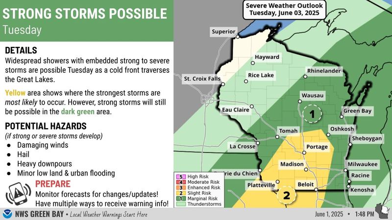
Strong storms could hit the Green Bay area on June 3, according to the National Weather Service Green Bay.

Between 2 and 10 p.m. is when the main impacts could occur. The Green Bay area is currently under a marginal risk for strong storms, though they are still possible. Roy Eckberg, meteorologist for the National Weather Service Green Bay, said the area could get half an inch to an inch of rain.
If the storms develop, damaging winds, hail, and minor flooding are all possible. Damaging wind gusts and frequent lightning are also in the forecast. Wind speeds of 11-17 mph are possible with gusts of 28 mph.
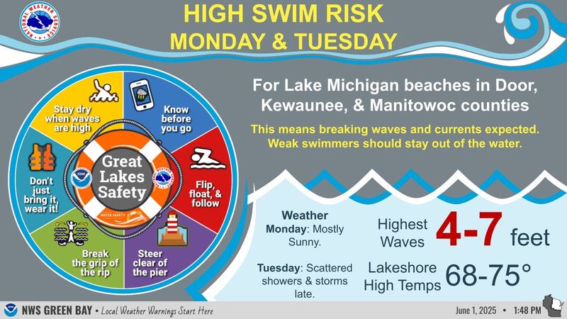
High swim risk warning
The weather service issued high swim risk warnings for Lake Michigan beaches in Door, Kewaunee and Manitowoc counties for June 2-3. Waves are expected to be as high as 4-7 feet. “Weak swimmers should stay out of the water,” the weather service said.
“When we get waves around 4 feet or higher, there’s an increased risk of rip currents. The south winds will help build the waves into Lake Michigan this afternoon and tonight, and the southerly winds will continue into tomorrow,” Eckberg told the Press-Gazette.
The weather service suggests swimmers avoid the water if the waves are high and to wear a life vest.
Green Bay weather forecast
High temperatures are in the forecast alongside the severe weather on June 3. Expect wind gusts as high as 33 mph. Here’s the forecast:
Rashad Alexander can be reached at ralexander@gannett.com and 920-431-8214.
This article originally appeared on Green Bay Press-Gazette: Green Bay could see severe weather June 3. High swim risk warning issued for Lake Michigan
Reporting by Rashad Alexander, Green Bay Press-Gazette / Green Bay Press-Gazette
USA TODAY Network via Reuters Connect