Friday is the first day of summer and it will definitely feel like it in the Greater Cincinnati area.
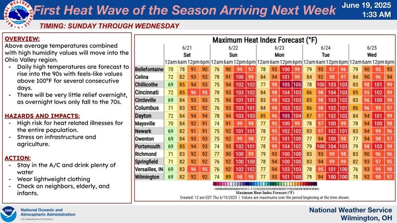
Temperatures are expected to be near or in 90s beginning June 20. Heat index values will make it feel over 100 degrees, the National Weather Service reports.

The sudden high temperatures are extreme enough that a hazardous weather outlook has been issued throughout parts of the Midwest, including in Hamilton County and Northern Kentucky. That means prolonged exposure to heat or excessive physical activity in the temperatures could cause heat stroke, heat cramps or heat exhaustion.
What’s causing the temperature surge?
A heat dome!
That’s a “strong bubble of high pressure” overhead, USA TODAY reported. When air sinks in the center of that bubble, it diminishes cloud coverage and allows intense sunshine to heat the area.
In addition, winds are expected to move hot and humid air from the South into the Midwest, the report states.
While temperatures will begin heating up this weekend, the worst of the weather is expected to hit early next week.
Here’s the forecast in Cincinnati to get you through the weekend and started into next week.
Friday, June 20: Mostly sunny with a high near 88 degrees, low near 68 degrees at night.
Saturday, June 21: Sunny with a high near 92 degrees and a low around 73 degrees at night.
Sunday, June 22: Sunny with a high near 96 degrees and a low around 74 degrees at night.
Monday, June 23: Sunny with a high around 97 degrees and a low around 75 degrees at night.
Tuesday, June 24: Sunny with a high near 96 degrees and a low around 75 degrees at night.
This article originally appeared on Cincinnati Enquirer: Scorching temperatures expected through weekend as heat dome sets in
Reporting by Jolene Almendarez, Cincinnati Enquirer / Cincinnati Enquirer
USA TODAY Network via Reuters Connect