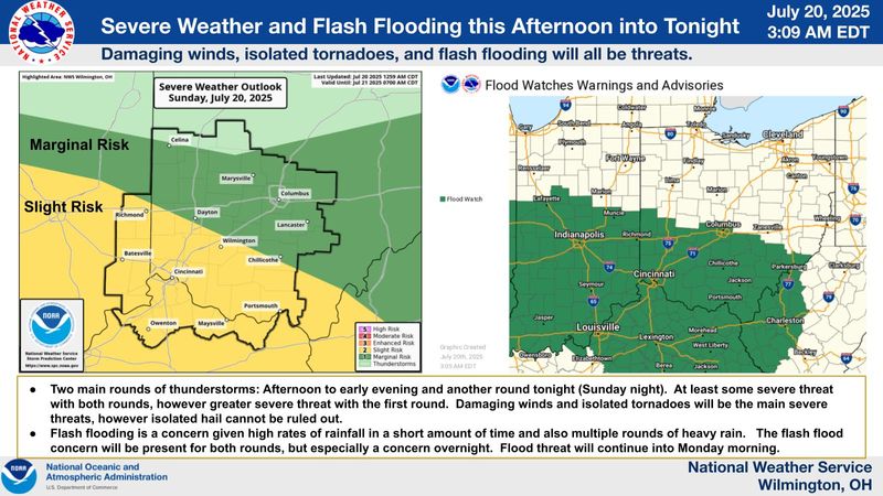
The National Weather Service in Wilmington issued a flood watch for most of central and southeast Ohio.
The watch begins at 1 p.m. July 20 and remains in effect until Monday morning, July 21. The watch includes downtown Columbus, Pickerington, Chillicothe, Springfield, Dayton, Lancaster, Cincinnati and some parts of eastern Indiana.

Strong thunderstorms were moving east through Indiana as of noon, July 20, and thunderstorms and showers were expected to begin in Franklin County sometime after 3 p.m., the NWS said. Some of those storms could see heavy rainfall.
“Excessive runoff may result in flooding of rivers, creeks, stream, and other low-lying and flood-prone locations,” according to the forecast. “Multiple rounds of thunderstorms will move across the watch area leading to the potential for flash flooding.”
The NWS issued a separate flood advisory until 6 p.m. July 20 for Fairfield, Fayette, Hocking, Ross and Pickaway counties, along with Ross County. The advisory said several locations could experience flooding, including Washington Court House, Circleville, Kingston, Williamsport, Bloomingburg, New Holland, Logan Elm Village, Fox, Stoutsville, Laurelville, Clarksburg, Adelphi, Tarlton and the Pickaway County Airport.
NWS meteorologist John Franks said people who live near creeks and streams are currently at greater risk of flooding as they are still swollen from rainfall in recent days. Smaller storms that hang over the region, dumping a lot of rain over a short period, creates a risk.
“The amount of moisture and structure of the storms is similar to what we’ve been looking at,” he said. “It’s going to depend on how it evolves and everything else. But the potential is there. The system is set up and ripe for tremendous rainfall rates if they get caught over a particular area.
“Creeks and streams are still high, so we’re keeping an eye on that.”
The forecast calls for showers to continue between 8 a.m. and 2 p.m. July 21 with a slight chance of thunderstorms after 2 p.m.
What’s the difference between a thunderstorm watch and a warning?
A severe thunderstorm watch is issued when severe thunderstorms are possible. The National Weather Service defines a severe thunderstorm as a storm with winds of 58 mph or higher and/or hail one inch in diameter or larger.
A severe thunderstorm warning is issued when a storm is occurring or is imminent.
How to track power outages in central Ohio
AEP Ohio serves Columbus and most of Eastern and Southern Ohio. Customers can view its power outage map here. You can report a power outage online or by calling 800-672-2231.
Columbus Division of Power customers can view an outage map here. DOP customers are encouraged to report outages not shown on the map by calling 614-645-7627.
FirstEnergy and its affiliates cover parts of Central Ohio to the north and west of Columbus. You can check FirstEnergy’s power outage map here. You can also report an outage online here or by phone at 888-544-4877, The Dispatch previously reported.
Central Ohio live weather radar
Columbus forecast for week of July 21, 2025
The National Weather Service in Wilmington issued the following forecast in Columbus for the week of July 21, 2025.
This article originally appeared on The Columbus Dispatch: Flood watch issued for Columbus, central Ohio. See where NWS says thunderstorms will strike
Reporting by Columbus Dispatch / The Columbus Dispatch
USA TODAY Network via Reuters Connect