Gov. Kathy Hochul declared a State of Emergency across 32 counties in New York as the state faces a one-two punch of severe weather and a dangerous heatwave.
Early Sunday, a line of intense thunderstorms swept across parts of the North Country, Central New York, the Southern Tier and the Capital Region. The storms brought damaging winds, torrential rain, flash flooding, downed trees, a deadly tornado and widespread power outages. Rainfall rates reached up to two inches per hour, with additional totals of 2 to 4 inches expected in areas already saturated.

Flash flooding remains a serious threat in parts of Central New York, the Southern Tier, and the Mid-Hudson region, particularly from Broome to Ulster and Sullivan counties. As of midday Sunday, approximately 50,000 customers were without power statewide.
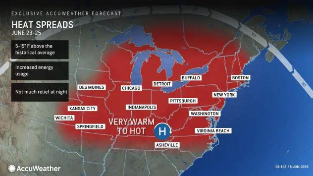
Simultaneously, a multi-day heatwave is underway. Feels-like temperatures are expected to reach between 90 and 105 degrees through Tuesday across much of the state.
“Our hearts break for the tragic loss of life during last night’s storms,” Hochul said. “We are coordinating closely with local officials and have state emergency crews already on the ground.”
In response, the State Emergency Operations Center has been activated. State agencies, including the Division of Homeland Security and Emergency Services and the Office of Fire Prevention and Control, are deploying resources such as light towers, pumps, generators and water rescue teams to impacted areas.
Residents are urged to remain alert, avoid flooded roadways, limit outdoor activities during peak heat and sign up for local emergency alerts by texting their county or borough name to 333111.
Counties under the State of Emergency include: Albany, Bronx, Broome, Chenango, Clinton, Columbia, Cortland, Delaware, Dutchess, Essex, Greene, Kings, Madison, Nassau, New York, Oneida, Onondaga, Orange, Otsego, Putnam, Queens, Rensselaer, Richmond, Rockland, Saratoga, Schenectady, Suffolk, Tioga, Ulster, Warren, Washington and Westchester.
When will the heat wave in NY end?
The most intense heat is expected to peak on Monday, with temperatures and humidity combining for heat index values as high as 110°F in some areas and closer to 105°F in other parts of the Empire State, according to the National Weather Service.
Conditions will remain hot on Tuesday, with highs still in the 90s and the heat index predicted to surpass 100 in some parts of the Southern Tier and Central New York, but temperatures are expected to cool down starting Wednesday.
Much of New York is under a heat advisory through Tuesday evening, according to the Weather Service.
Several Southern Tier and Central New York counties are under an extreme heat warning through Monday evening. In those spots – including Onondaga, Schuyler, Chemung, Tompkins, Tioga and Broome counties – “dangerously hot conditions” are predicted Monday, with heat index predicted to reach up to 110.
In Rochester, the high reached 90 degrees on Sunday, which marked the warmest day of 2025 to date, according to the National Weather Service in Buffalo. It also reached 90 degrees in Poughkeepsie, 88 degrees in Syracuse as well as Central Park in New York City, 84 degrees in Albany and 82 degrees in Buffalo, according to Weather Service data. It reached 91 degrees at JFK International Airport in Queens and in Islip, Suffolk County, on Long Island.
The high in parts of western New York is predicted to reach the mid-90s Sunday
By midweek, many areas could see a return to more typical summer temperatures in the low to mid-80s, according to forecasters.
Health risks and who’s most affected
Extended periods of high heat and humidity can cause heat-related illnesses, particularly for:
How to stay safe until the heat breaks
This article originally appeared on Rochester Democrat and Chronicle: NY declares state of emergency as flooding, power outages and dangerous heat wave hit
Reporting by Victoria E. Freile, New York Connect Team / Rochester Democrat and Chronicle
USA TODAY Network via Reuters Connect